

and “Middle Terrace” surfaces were built in the mid-Middle
Pleistocene, the late Middle Pleistocene, and the early Late
Pleistocene, respectively. Brown soil (5YR 4/8—2.5YR 4/6)
is generally developed on the Highest Terrace surface,
though its thickness and color are variable. Reddish
Red-Yellow soil of [5YR 3/6—2.5YR 4/6] and [5YR 4/8—
2.5YR 4/6] covers the surface of part of the upper-Higher
Terrace and lower-Higher Terrace, respectively. NonAllophanic Andosols cover the very top of the Middle
Terrace everywhere, while Andosols occupy the top of the
soil profile on the Middle Terrace in this area.
(3) Soils on lowlands
Fluvic soils are generally distributed in the lowlands of the
Chubu region. In the lowlands of the Izu Peninsula and the
surrounding areas affected by the activity of Quaternary
volcanoes, many Alluvial Andosols are redeposited by rivers. Consequently, Wet Andosols are distributed in places
with poor drainage and in alluvial plains. This soil is used as
paddy fields, while places with relatively good drainage are
used as upland fields (Shizuoka Prefecture 2014). In midwestern Shizuoka Prefecture, Gray Fluvic soils are widely
distributed in alluvial plains, alluvial fans, and valley-bottom
plains and are used as rice paddies; they are also distributed
in upland fields and orchard fields. A total of 40% of the
soils of the paddy fields of midwestern Shizuoka Prefecture
have a gley horizon, the depths of which have increased in
recent years as a result of the construction of underdrainage
and open-channel drainage to the paddy fields (Shizuoka
Prefecture 2014).
The Noubi Plain, an alluvial plain, is distributed among
the southern part of Gifu Prefecture, the eastern part of Mie
Prefecture, and the western part of Aichi Prefecture. The Kiso
River, Ibi River, and Nagara River—the so-called Kiso Three
Rivers—flow through this plain. In the downstream part of
the Nobi Plain, areas with elevations below sea level are
distributed. Many of the branches of the Kiso Three Rivers in
these areas are raised-bed rivers. Consequently, Gley Fluvic
soils are distributed in the paddy fields of these areas. It has
been reported that the gley horizons disappeared after the
dredging of riverbed to reduce flooding (Kitamura 2007).
In Hokuriku region, on the Sea of Japan side, Gray Fluvic
soils are distributed on its alluvial fan, and Gley Fluvic soils
are distributed in lowlands along rivers and coasts. These tow
soils account for 70–80% of lowland soil in the Hokuriku
region (Sage 1998). In the western and eastern part of Toyama
Prefecture, alluvial fans are distributed in the lowlands.
Consequently, the soil textures in these areas are coarse, and
skeletal Gray Lowland soils are distributed. The plow layer is
very thin, and the gravel layer exists at shallow depth, especially in the alluvial fan of the Kurobe river basin in the
eastern part of Toyama Prefecture (Fig. 8.7) (Yamada 2007a).
(4) Sandy soil
Sandy Regosols are distributed in a sand dune on the
coastline from Lake Hamana to Cape Omaezaki (Fig. 8.7)
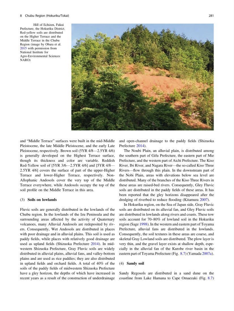
Fig. 8.8 Hill of Echizen, Fukui
Prefecture, the Hokuriku District.
Red-yellow soils are distributed
on the Higher Terrace and the
Middle Terrace in the Chubu
Region (image by Obara et al.
2015 with permission from
National Institute for
Agro-Environmental Sciences
NARO)
8 Chubu Region (Hokuriku/Tokai)
281
Pleistocene, the late Middle Pleistocene, and the early Late
Pleistocene, respectively. Brown soil (5YR 4/8—2.5YR 4/6)
is generally developed on the Highest Terrace surface,
though its thickness and color are variable. Reddish
Red-Yellow soil of [5YR 3/6—2.5YR 4/6] and [5YR 4/8—
2.5YR 4/6] covers the surface of part of the upper-Higher
Terrace and lower-Higher Terrace, respectively. NonAllophanic Andosols cover the very top of the Middle
Terrace everywhere, while Andosols occupy the top of the
soil profile on the Middle Terrace in this area.
(3) Soils on lowlands
Fluvic soils are generally distributed in the lowlands of the
Chubu region. In the lowlands of the Izu Peninsula and the
surrounding areas affected by the activity of Quaternary
volcanoes, many Alluvial Andosols are redeposited by rivers. Consequently, Wet Andosols are distributed in places
with poor drainage and in alluvial plains. This soil is used as
paddy fields, while places with relatively good drainage are
used as upland fields (Shizuoka Prefecture 2014). In midwestern Shizuoka Prefecture, Gray Fluvic soils are widely
distributed in alluvial plains, alluvial fans, and valley-bottom
plains and are used as rice paddies; they are also distributed
in upland fields and orchard fields. A total of 40% of the
soils of the paddy fields of midwestern Shizuoka Prefecture
have a gley horizon, the depths of which have increased in
recent years as a result of the construction of underdrainage
and open-channel drainage to the paddy fields (Shizuoka
Prefecture 2014).
The Noubi Plain, an alluvial plain, is distributed among
the southern part of Gifu Prefecture, the eastern part of Mie
Prefecture, and the western part of Aichi Prefecture. The Kiso
River, Ibi River, and Nagara River—the so-called Kiso Three
Rivers—flow through this plain. In the downstream part of
the Nobi Plain, areas with elevations below sea level are
distributed. Many of the branches of the Kiso Three Rivers in
these areas are raised-bed rivers. Consequently, Gley Fluvic
soils are distributed in the paddy fields of these areas. It has
been reported that the gley horizons disappeared after the
dredging of riverbed to reduce flooding (Kitamura 2007).
In Hokuriku region, on the Sea of Japan side, Gray Fluvic
soils are distributed on its alluvial fan, and Gley Fluvic soils
are distributed in lowlands along rivers and coasts. These tow
soils account for 70–80% of lowland soil in the Hokuriku
region (Sage 1998). In the western and eastern part of Toyama
Prefecture, alluvial fans are distributed in the lowlands.
Consequently, the soil textures in these areas are coarse, and
skeletal Gray Lowland soils are distributed. The plow layer is
very thin, and the gravel layer exists at shallow depth, especially in the alluvial fan of the Kurobe river basin in the
eastern part of Toyama Prefecture (Fig. 8.7) (Yamada 2007a).
(4) Sandy soil
Sandy Regosols are distributed in a sand dune on the
coastline from Lake Hamana to Cape Omaezaki (Fig. 8.7)
Fig. 8.8 Hill of Echizen, Fukui
Prefecture, the Hokuriku District.
Red-yellow soils are distributed
on the Higher Terrace and the
Middle Terrace in the Chubu
Region (image by Obara et al.
2015 with permission from
National Institute for
Agro-Environmental Sciences
NARO)
8 Chubu Region (Hokuriku/Tokai)
281