

exchangeable bases increased at almost the same rate, resulting
in a high degree of base saturation (100%) during the 125-year
period of the initial soil formation processes of Volcanogenous
Regosols. For 125 years after the 1874 eruption, the base saturation degree was always maintained at 100%. The increased
amount of soil basic nutrients is thought to be limited by
nutrient retention capacity. In young volcanic soils, the circumstances in which supply capacity exceeds nutrient retention
capacity are maintained. If the soil nutrient amount reaches the
prescribed value necessary for the establishment of a plant
community “A” by the soil formation, the plant community “A”
is established by the vegetation succession. Plant community
“A” contributes to soil formation that shifts to the stage of the
next soil nutrient state (the amount of soil nutrients necessary for
the transition to plant community B). In the initial soil formation
process, the nutrient state of the soil and the succession stage of
the vegetation are closely related. In other words, in Miyakejima
the initial soil formation process on the timescale of 125 years
with scoria as a base material is closely related with vegetation
transition.
(2) Very early stage of pedogenesis derived from volcanic ash
The eruption of Miyakejima in 2000 was characterized by
the accumulation of several millimeters to several dozens of
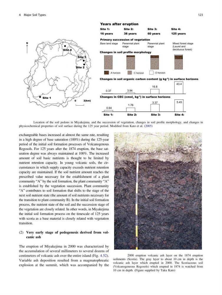
centimeters of volcanic ash over the entire island (Fig. 4.52).
Variable ash deposition resulted from a magmatophreatic
explosion at the summit, which was accompanied by the
Years after eruption
16 years
38 years
60 years
125 years
: A horizon
: C horizon
Primary succession of vegetation
Bare land stage
Perennial plant
stage
Perennial plant
stage
Mixed forest stage
(Laurel and
deciduous forest)
: O horizon
Changes in soil profile morphology
Site 4
Site 3
Site 2
Site 1
Site 1:
Site 2:
Site 3:
Site 4:
Changes in soil organic carbon content (g kg -1 ) in surface horizons
0.37
3.94
16.8
43.4
Changes in CEC (cmol c kg -1 ) in surface horizons
0.64
1.76
3.37
5.45
Site 1:
Site 2:
Site 3:
Site 4:
0
2(km)
N
Fig. 4.51 Location of the soil pedons in Miyakejima, and the succession of vegetation, changes in soil profile morphology, and changes in
physicochemical properties of soil surface during the 125 year period. Modified from Kato et al. (2005)
Fig. 4.52 2000 eruption volcanic ash layer on the 1874 eruption
sediments (Scoria). The gray layer to about 10 cm in depth is the
volcanic ash layer which erupted in 2000. The Scoriaceous soil
(Volcanogeneous Regosols) which erupted in 1874 is watched from
10 cm in depth. (Figure supplied by Taku Kato)
4 Major Soil Types
123
in a high degree of base saturation (100%) during the 125-year
period of the initial soil formation processes of Volcanogenous
Regosols. For 125 years after the 1874 eruption, the base saturation degree was always maintained at 100%. The increased
amount of soil basic nutrients is thought to be limited by
nutrient retention capacity. In young volcanic soils, the circumstances in which supply capacity exceeds nutrient retention
capacity are maintained. If the soil nutrient amount reaches the
prescribed value necessary for the establishment of a plant
community “A” by the soil formation, the plant community “A”
is established by the vegetation succession. Plant community
“A” contributes to soil formation that shifts to the stage of the
next soil nutrient state (the amount of soil nutrients necessary for
the transition to plant community B). In the initial soil formation
process, the nutrient state of the soil and the succession stage of
the vegetation are closely related. In other words, in Miyakejima
the initial soil formation process on the timescale of 125 years
with scoria as a base material is closely related with vegetation
transition.
(2) Very early stage of pedogenesis derived from volcanic ash
The eruption of Miyakejima in 2000 was characterized by
the accumulation of several millimeters to several dozens of
centimeters of volcanic ash over the entire island (Fig. 4.52).
Variable ash deposition resulted from a magmatophreatic
explosion at the summit, which was accompanied by the
Years after eruption
16 years
38 years
60 years
125 years
: A horizon
: C horizon
Primary succession of vegetation
Bare land stage
Perennial plant
stage
Perennial plant
stage
Mixed forest stage
(Laurel and
deciduous forest)
: O horizon
Changes in soil profile morphology
Site 4
Site 3
Site 2
Site 1
Site 1:
Site 2:
Site 3:
Site 4:
Changes in soil organic carbon content (g kg -1 ) in surface horizons
0.37
3.94
16.8
43.4
Changes in CEC (cmol c kg -1 ) in surface horizons
0.64
1.76
3.37
5.45
Site 1:
Site 2:
Site 3:
Site 4:
0
2(km)
N
Fig. 4.51 Location of the soil pedons in Miyakejima, and the succession of vegetation, changes in soil profile morphology, and changes in
physicochemical properties of soil surface during the 125 year period. Modified from Kato et al. (2005)
Fig. 4.52 2000 eruption volcanic ash layer on the 1874 eruption
sediments (Scoria). The gray layer to about 10 cm in depth is the
volcanic ash layer which erupted in 2000. The Scoriaceous soil
(Volcanogeneous Regosols) which erupted in 1874 is watched from
10 cm in depth. (Figure supplied by Taku Kato)
4 Major Soil Types
123