

136
C. Winograd
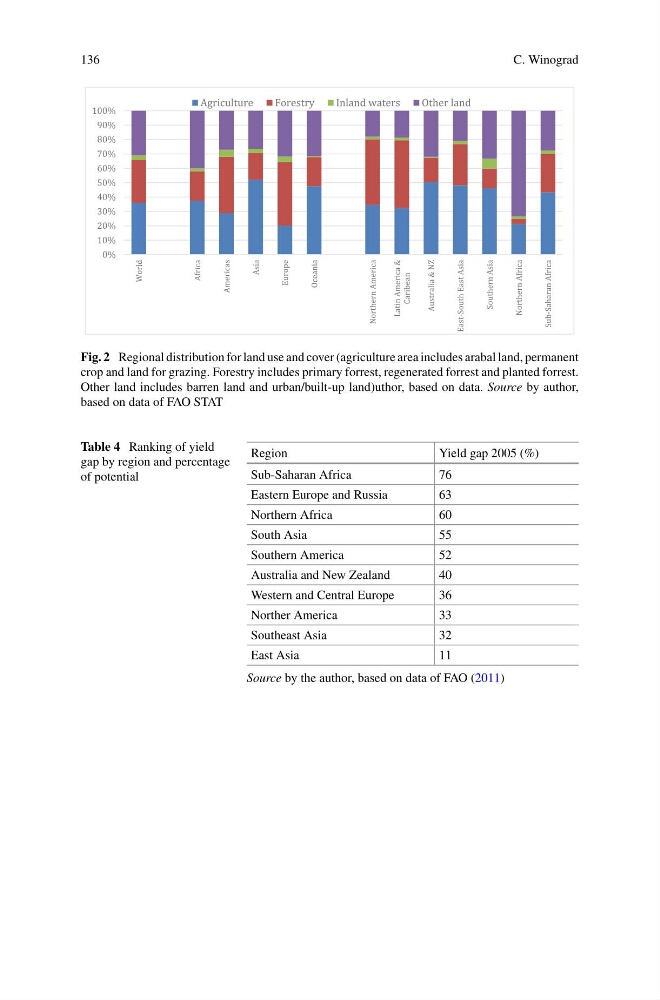
Fig. 2 Regional distribution for land use and cover (agriculture area includes arabal land, permanent
crop and land for grazing. Forestry includes primary forrest, regenerated forrest and planted forrest.
Other land includes barren land and urban/built-up land)uthor, based on data. Source by author,
based on data of FAO STAT
Table 4 Ranking of yield
gap by region and percentage
of potential
Region
Yield gap 2005 (%)
Sub-Saharan Africa
76
Eastern Europe and Russia
63
Northern Africa
60
South Asia
55
Southern America
52
Australia and New Zealand
40
Western and Central Europe
36
Norther America
33
Southeast Asia
32
East Asia
11
Source by the author, based on data of FAO (2011)
C. Winograd
Fig. 2 Regional distribution for land use and cover (agriculture area includes arabal land, permanent
crop and land for grazing. Forestry includes primary forrest, regenerated forrest and planted forrest.
Other land includes barren land and urban/built-up land)uthor, based on data. Source by author,
based on data of FAO STAT
Table 4 Ranking of yield
gap by region and percentage
of potential
Region
Yield gap 2005 (%)
Sub-Saharan Africa
76
Eastern Europe and Russia
63
Northern Africa
60
South Asia
55
Southern America
52
Australia and New Zealand
40
Western and Central Europe
36
Norther America
33
Southeast Asia
32
East Asia
11
Source by the author, based on data of FAO (2011)