

128
Sensemaking in Safety Critical and Complex Situations
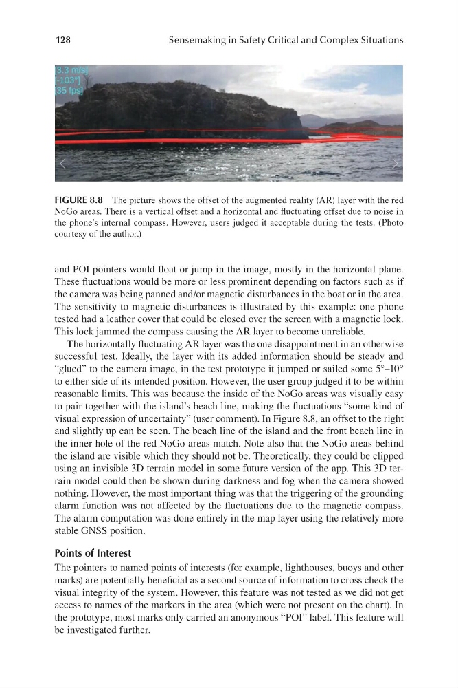
FIGURE 8.8 The picture shows the offset of the augmented reality ( AR) layer with the red
NoGo areas. There is a vertical offset and a horizontal and fluctuating offset due to noise in
the phone’s internal compass. However, users judged it acceptable during the tests. ( Photo
courtesy of the author.)
and POI pointers would float or jump in the image, mostly in the horizontal plane.
These fluctuations would be more or less prominent depending on factors such as if
the camera was being panned and/ or magnetic disturbances in the boat or in the area.
The sensitivity to magnetic disturbances is illustrated by this example: one phone
tested had a leather cover that could be closed over the screen with a magnetic lock.
This lock jammed the compass causing the AR layer to become unreliable.
The horizontally fluctuating AR layer was the one disappointment in an otherwise
successful test. Ideally, the layer with its added information should be steady and
“ glued” to the camera image, in the test prototype it jumped or sailed some 5°–10°
to either side of its intended position. However, the user group judged it to be within
reasonable limits. This was because the inside of the NoGo areas was visually easy
to pair together with the island’s beach line, making the fluctuations “ some kind of
visual expression of uncertainty” (us er comment). In Figure 8.8, an offset to the right
and slightly up can be seen. The beach line of the island and the front beach line in
the inner hole of the red NoGo areas match. Note also that the NoGo areas behind
the island are visible which they should not be. Theoretically, they could be clipped
using an invisible 3D terrain model in some future version of the app. This 3D terrain model could then be shown during darkness and fog when the camera showed
nothing. However, the most important thing was that the triggering of the grounding
alarm function was not affected by the fluctuations due to the magnetic compass.
The alarm computation was done entirely in the map layer using the relatively more
stable GNSS position.
Points of Interest
The pointers to named points of interests ( for example, lighthouses, buoys and other
marks) are potentially beneficial as a second source of information to cross check the
visual integrity of the system. However, this feature was not tested as we did not get
access to names of the markers in the area ( which were not present on the chart). In
the prototype, most marks only carried an anonymous “ POI” label. This feature will
be investigated further.
Sensemaking in Safety Critical and Complex Situations
FIGURE 8.8 The picture shows the offset of the augmented reality ( AR) layer with the red
NoGo areas. There is a vertical offset and a horizontal and fluctuating offset due to noise in
the phone’s internal compass. However, users judged it acceptable during the tests. ( Photo
courtesy of the author.)
and POI pointers would float or jump in the image, mostly in the horizontal plane.
These fluctuations would be more or less prominent depending on factors such as if
the camera was being panned and/ or magnetic disturbances in the boat or in the area.
The sensitivity to magnetic disturbances is illustrated by this example: one phone
tested had a leather cover that could be closed over the screen with a magnetic lock.
This lock jammed the compass causing the AR layer to become unreliable.
The horizontally fluctuating AR layer was the one disappointment in an otherwise
successful test. Ideally, the layer with its added information should be steady and
“ glued” to the camera image, in the test prototype it jumped or sailed some 5°–10°
to either side of its intended position. However, the user group judged it to be within
reasonable limits. This was because the inside of the NoGo areas was visually easy
to pair together with the island’s beach line, making the fluctuations “ some kind of
visual expression of uncertainty” (us er comment). In Figure 8.8, an offset to the right
and slightly up can be seen. The beach line of the island and the front beach line in
the inner hole of the red NoGo areas match. Note also that the NoGo areas behind
the island are visible which they should not be. Theoretically, they could be clipped
using an invisible 3D terrain model in some future version of the app. This 3D terrain model could then be shown during darkness and fog when the camera showed
nothing. However, the most important thing was that the triggering of the grounding
alarm function was not affected by the fluctuations due to the magnetic compass.
The alarm computation was done entirely in the map layer using the relatively more
stable GNSS position.
Points of Interest
The pointers to named points of interests ( for example, lighthouses, buoys and other
marks) are potentially beneficial as a second source of information to cross check the
visual integrity of the system. However, this feature was not tested as we did not get
access to names of the markers in the area ( which were not present on the chart). In
the prototype, most marks only carried an anonymous “ POI” label. This feature will
be investigated further.