

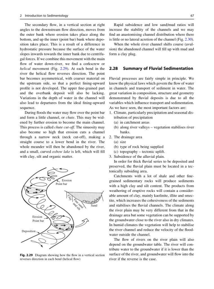
The secondary flow, in a vertical section at right
angles to the downstream flow direction, moves from
the outer bank where erosion takes place along the
bottom, and up the inner (point bar) bank where deposition takes place. This is a result of a difference in
hydrostatic pressure because the surface of the water
slopes inwards towards the inner bank due to centrifugal forces. If we combine this movement with the main
flow of water down-river, we find a corkscrew or
helical movement (Fig. 2.29). At each bend in the
river the helical flow reverses direction. The point
bar becomes asymmetrical, with coarser material on
the upstream side, so that a perfect fining-upward
profile is not developed. The upper fine-grained part
and the overbank deposit will also be lacking.
Variations in the depth of water in the channel will
also lead to departures from the ideal fining-upward
sequence.
During floods the water may flow over the point bar
and form a little channel, or chute. This may be widened by further erosion to become the main channel.
This process is called chute cut-off. The sinuosity may
also become so high that erosion cuts a channel
through a narrow neck (neck cut-off), making a
straight course to a lower bend in the river. The
whole meander will then be abandoned by the river,
and a small, curved oxbow lake is left, which will fill
with clay, silt and organic matter.
Rapid subsidence and low sand/mud ratios will
increase the stability of the channels and we may
find an anastomising channel distribution where there
is little or no lateral acretion of the channel (Fig. 2.30).
When the whole river channel shifts course (avulsion) the abandoned channel will fill up with mud and
form a clay plug.
2.28 Summary of Fluvial Sedimentation
Fluvial processes are fairly simple in principle. We
know the physical laws which govern the flow of water
in channels and transport of sediment in water. The
great variation in composition, structure and geometry
demonstrated by fluvial deposits is due to all the
variables which influence transport and sedimentation.
As we have seen, the most important factors are:
1. Climate, particularly precipitation and seasonal distribution of precipitation
(a) in catchment areas
(b) along river valleys – vegetation stabilises river
banks.
2. The drainage area
(a) size
(b) type of rock being supplied
(c) topography – tectonic uplift.
3. Subsidence of the alluvial plain.
In order for thick fluvial series to be deposited and
preserved, the fluvial plain must be located in a tectonically subsiding area.
Catchments with a lot of shale and other finegrained sedimentary rocks will produce sediments
with a high clay and silt content. The products from
weathering of eruptive rocks will contain a considerable amount of clay, mainly kaolinite, illite and smectite, which increases the cohesiveness of the sediments
and stabilises the fluvial channels. The climate along
the river plain may be very different from that in the
drainage area but some vegetation can be supported by
the groundwater close to the river also in dry climates.
In humid climates the vegetation will help to stabilise
the river channel and reduce the velocity of the floodwater outside the channel.
The flow of rivers on the river plain will also
depend on the groundwater table. The river will contribute water to the groundwater if it is lower than the
surface of the river, and groundwater will flow into the
river if the reverse is the case.
Erosion
Sand
Erosion
Deposition
Point bar
a
n
d
s
i
l
t
F i n e s a n d
C
l
a
y
Point bar
Fig. 2.29 Diagram showing how the flow in a vertical section
reverses direction in each bend (helical flow)
2 Introduction to Sedimentology
67
angles to the downstream flow direction, moves from
the outer bank where erosion takes place along the
bottom, and up the inner (point bar) bank where deposition takes place. This is a result of a difference in
hydrostatic pressure because the surface of the water
slopes inwards towards the inner bank due to centrifugal forces. If we combine this movement with the main
flow of water down-river, we find a corkscrew or
helical movement (Fig. 2.29). At each bend in the
river the helical flow reverses direction. The point
bar becomes asymmetrical, with coarser material on
the upstream side, so that a perfect fining-upward
profile is not developed. The upper fine-grained part
and the overbank deposit will also be lacking.
Variations in the depth of water in the channel will
also lead to departures from the ideal fining-upward
sequence.
During floods the water may flow over the point bar
and form a little channel, or chute. This may be widened by further erosion to become the main channel.
This process is called chute cut-off. The sinuosity may
also become so high that erosion cuts a channel
through a narrow neck (neck cut-off), making a
straight course to a lower bend in the river. The
whole meander will then be abandoned by the river,
and a small, curved oxbow lake is left, which will fill
with clay, silt and organic matter.
Rapid subsidence and low sand/mud ratios will
increase the stability of the channels and we may
find an anastomising channel distribution where there
is little or no lateral acretion of the channel (Fig. 2.30).
When the whole river channel shifts course (avulsion) the abandoned channel will fill up with mud and
form a clay plug.
2.28 Summary of Fluvial Sedimentation
Fluvial processes are fairly simple in principle. We
know the physical laws which govern the flow of water
in channels and transport of sediment in water. The
great variation in composition, structure and geometry
demonstrated by fluvial deposits is due to all the
variables which influence transport and sedimentation.
As we have seen, the most important factors are:
1. Climate, particularly precipitation and seasonal distribution of precipitation
(a) in catchment areas
(b) along river valleys – vegetation stabilises river
banks.
2. The drainage area
(a) size
(b) type of rock being supplied
(c) topography – tectonic uplift.
3. Subsidence of the alluvial plain.
In order for thick fluvial series to be deposited and
preserved, the fluvial plain must be located in a tectonically subsiding area.
Catchments with a lot of shale and other finegrained sedimentary rocks will produce sediments
with a high clay and silt content. The products from
weathering of eruptive rocks will contain a considerable amount of clay, mainly kaolinite, illite and smectite, which increases the cohesiveness of the sediments
and stabilises the fluvial channels. The climate along
the river plain may be very different from that in the
drainage area but some vegetation can be supported by
the groundwater close to the river also in dry climates.
In humid climates the vegetation will help to stabilise
the river channel and reduce the velocity of the floodwater outside the channel.
The flow of rivers on the river plain will also
depend on the groundwater table. The river will contribute water to the groundwater if it is lower than the
surface of the river, and groundwater will flow into the
river if the reverse is the case.
Erosion
Sand
Erosion
Deposition
Point bar
a
n
d
s
i
l
t
F i n e s a n d
C
l
a
y
Point bar
Fig. 2.29 Diagram showing how the flow in a vertical section
reverses direction in each bend (helical flow)
2 Introduction to Sedimentology
67