

is found as far north as the Fingerdjupet Sub-basin.
The erosional surface associated with this rift phase
extends from the Loppa High to the Stappen High, and
Permian tectonic activity is known to have occurred on
Bjørnøya and on the Sørkapp High in the southern part
of Spitsbergen. Therefore the rift phase probably
affected a narrow northerly trending zone along the
entire present western margin.
25.4.2.2 Mesozoic
In Early Triassic time a regional deepwater basin
covered much of the Barents Sea. During the relatively
short Triassic period large amounts of clastic
sediments were deposited. The Uralian highland to
the east was an important sediment source. Sediments
were also shed into the Barents Sea from the Baltic
Shield and from other local source areas. Differential
loading triggered salt diapirism in the Nordkapp Basin
(Fig. 25.18) and possibly later also in other salt basins
in the SW Barents Sea.
The Triassic strata are dominated by shales and
sandstones, the vertical and lateral distribution of
which is complex. There seems to be an increased
content of coarse clastic rocks in the younger intervals.
A similar increase is also observed in an easterly and a
southerly direction towards the main sediment source
area. Marine conditions prevailed in Late Permian and
Early Triassic times followed by a shallowing and
partial exposure of some areas. The continental regime
prevailed in large areas in Middle Triassic time and the
northward and westward prograding deltaic system
continued to infill the regional basin.
In the central and northern basin areas marine
conditions existed throughout the Middle Triassic. A
good Middle Triassic source rock is known from
Svalbard and this is probably present in large parts of
the western Barents Sea. In the Late Triassic the
shoreline was moved back to the southern and eastern
borders of the SE Barents Sea basin. The Triassic
ended with regression and erosion. Late Triassic
sediments were also derived from other source areas,
mainly in the northwest.
The Lower-Middle Jurassic interval is dominated
by sandstones throughout the Barents Sea. These
Hornsund sheared margin
W
E
HFZ
0
10
20
km
30
0
100
200
W
0
10
20
km
30
0
200
HFZ
E
0
10
20
km
30
Vestbakken rifted margin
100
200
LB
W
E
0
300 km
300 km
300 km
100
Svalbard margin
BFZ
Cenozoic
Devonian
Cretaceous
Lower Mesozoic -
Upper Palaeozoic
Continental basement
Oceanic basement
Extrusives
18
19
20
CB
Svalbard Platform
Bjørnøya Basin Loppa High
Vestbakken Volcanic Province
KFC
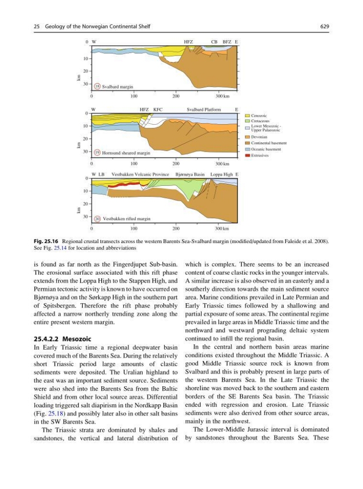
Fig. 25.16 Regional crustal transects across the western Barents Sea-Svalbard margin (modified/updated from Faleide et al. 2008).
See Fig. 25.14 for location and abbreviations
25 Geology of the Norwegian Continental Shelf
629