

regionally in the SW Barents Sea (also on the NE
Greenland shelf/margin).
The thickness of the salt layer in the Nordkapp
Basin (Fig. 25.18), which is inferred to have reached
4–5 km locally, implies that a substantial faultgenerated depression was in place or developed during
early Late Carboniferous times. Not all of this thickness corresponds to a fault-defined relief, however,
because salt was also deposited in the basin during
the subsequent phase of differential thermal subsidence. Still, a considerable fault-bounded basin must
have existed.
From Bashkirian to Artinskian/Early Kungurian
times, carbonate deposition took place on a broad
shelf. Carbonate build-ups were common at basin
margins and intrabasinal highs controlled by underlying older structures. Following Gzelian-Asselian/
Sakmarian deposition of basinal evaporites and
growth of marginal carbonate build-ups, a regional
shallow-water carbonate platform was established during Sakmarian-Artinskian times. Carbonate sedimentation occurred in the entire region until late Early
Permian time when clastic deposition started to dominate the area (Fig. 25.4). The change to platform type
sedimentation marked the initial development of a
regional sag basin which continued to subside in the
Late Permian during the deposition of cherty
limestones and shales.
The western part of the rift system was affected by
renewed faulting, uplift and erosion in Permian-Early
Triassic times. Normal faulting along the western
margin of the Loppa High (Figs. 25.19 and 25.20) as
well as the uplift, tilting and erosional truncation of the
high itself are of sufficient magnitude to indicate a
significant Permian-Early Triassic rift phase affecting
the N-S structural trend. Evidence of fault movements
NW
SE
Nordkapp Basin
Ottar Basin
Loppa High
s twt
SW
NE
Sørvestsnaget Basin
Bjørnøya Basin
Fingerdjupet Sub-basin
0
2
4
6
8
10
SE
NW
Nordkapp Basin
Ottar Basin
Finnmark Platform
s twt
0
2
4
6
8
Salt
Middle Jurassic - Triassic
Lower Cretaceous -
Upper Jurassic
Upper Cretaceous
Upper Palaeozoic
Palaeogene
Neogene
10 km
s twt
0
2
4
6
8
10 km
10 km
10 km
s twt
0
2
4
6
8
10
W
Lofoten Basin
Sørvestsnaget Basin Senja Ridge
Tromsø Basin
Hammerfest Basin
E
14
15
16
17
Maud Basin
MH
NH
Finnmark Platform
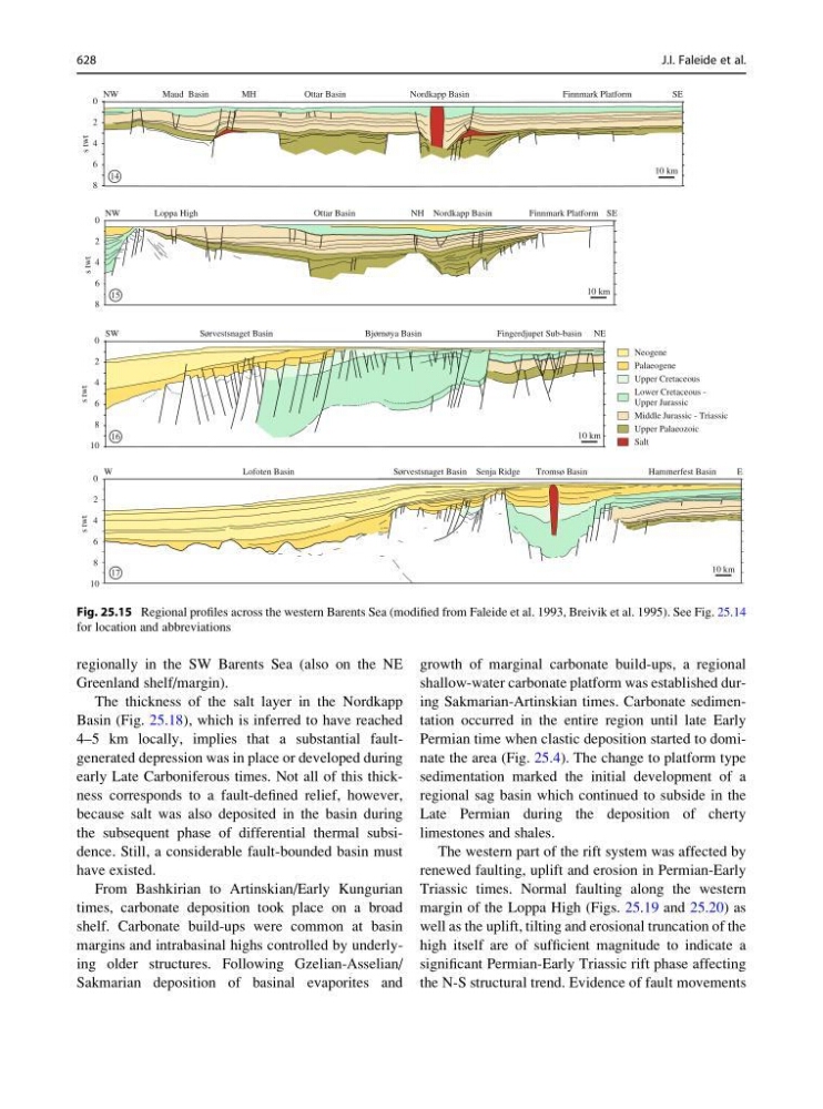
Fig. 25.15 Regional profiles across the western Barents Sea (modified from Faleide et al. 1993, Breivik et al. 1995). See Fig. 25.14
for location and abbreviations
628
J.I. Faleide et al.