

Although Devonian sediments in the northern
North Sea have been reached in only a few wells,
there are reasons to believe that Devonian sediments
are present regionally in the deeper parts of the preTriassic half-grabens beneath the Horda Platform,
Viking Graben and East Shetland Basin. The presence of Upper Palaeozoic rocks, of both Devonian
and Lower Permian age (Rotliegendes), has also
been confirmed by drilling on the East Shetland
Platform. Seismic data reveal large sedimentary
basins beneath the platform, thought to contain
Upper Palaeozoic (Devonian-Carboniferous) rocks.
In this context it is important to note that oil is
produced from Devonian sandstones in the Embla
Field of the Central Graben.
The Caledonian plate movement changed from
subduction to Late Devonian lateral (strike-slip)
movement between Greenland and Fennoscandia,
including along the Great Glen Fault. In Scotland
this was marked by active volcanism, especially in
the Midland Valley Rift.
25.2.2.2 Carboniferous
Following the markedly dry climate which prevailed
through Devonian time in the North Sea region, the
Carboniferous period gradually became more humid.
Northwest Europe moved northwards from the arid
belt of the southern hemisphere into the humid equatorial belt. This provided the basis for all the coal
deposits. There was also a marked transgression over
large areas. The strike-slip movements along the
Greenland/Fennoscandia plate boundary ceased at
the transition from Devonian to Carboniferous, and
ever since this has been an area of diverging plate
movement and rift formation until final continental
break-up and onset of seafloor spreading in earliest
Eocene time. There was rifting in the Midland Valley
of Scotland, continuing along the Forth Approahes
into the Witch Ground Graben which was a volcanic
centre in the North Sea. Black mud deposited in these
graben structures forms source rocks for oil.
There was no rifting in England at that time and
the Carboniferous Limestone was deposited as a shelf
carbonate during the Early Carboniferous. North of the
1
0
2
3
4
5
25 km
s
twt
NW
SE
Horda Platform
Viking Graben
Tampen Spur
East Shetland Basin
2
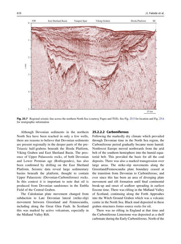
Fig. 25.7 Regional seismic line across the northern North Sea (courtesy Fugro and TGS). See Fig. 25.5 for location and Fig. 25.6
for stratigraphic information
610
J.I. Faleide et al.
North Sea have been reached in only a few wells,
there are reasons to believe that Devonian sediments
are present regionally in the deeper parts of the preTriassic half-grabens beneath the Horda Platform,
Viking Graben and East Shetland Basin. The presence of Upper Palaeozoic rocks, of both Devonian
and Lower Permian age (Rotliegendes), has also
been confirmed by drilling on the East Shetland
Platform. Seismic data reveal large sedimentary
basins beneath the platform, thought to contain
Upper Palaeozoic (Devonian-Carboniferous) rocks.
In this context it is important to note that oil is
produced from Devonian sandstones in the Embla
Field of the Central Graben.
The Caledonian plate movement changed from
subduction to Late Devonian lateral (strike-slip)
movement between Greenland and Fennoscandia,
including along the Great Glen Fault. In Scotland
this was marked by active volcanism, especially in
the Midland Valley Rift.
25.2.2.2 Carboniferous
Following the markedly dry climate which prevailed
through Devonian time in the North Sea region, the
Carboniferous period gradually became more humid.
Northwest Europe moved northwards from the arid
belt of the southern hemisphere into the humid equatorial belt. This provided the basis for all the coal
deposits. There was also a marked transgression over
large areas. The strike-slip movements along the
Greenland/Fennoscandia plate boundary ceased at
the transition from Devonian to Carboniferous, and
ever since this has been an area of diverging plate
movement and rift formation until final continental
break-up and onset of seafloor spreading in earliest
Eocene time. There was rifting in the Midland Valley
of Scotland, continuing along the Forth Approahes
into the Witch Ground Graben which was a volcanic
centre in the North Sea. Black mud deposited in these
graben structures forms source rocks for oil.
There was no rifting in England at that time and
the Carboniferous Limestone was deposited as a shelf
carbonate during the Early Carboniferous. North of the
1
0
2
3
4
5
25 km
s
twt
NW
SE
Horda Platform
Viking Graben
Tampen Spur
East Shetland Basin
2
Fig. 25.7 Regional seismic line across the northern North Sea (courtesy Fugro and TGS). See Fig. 25.5 for location and Fig. 25.6
for stratigraphic information
610
J.I. Faleide et al.