

carbonate platform and in much of the North Sea,
deeper water shales predominated, with some carbonate. Sandstones are encountered higher up in the
Lower Carboniferous and these can be important reservoir rocks in the southern North Sea (Fell Sandstone). At the Lower/Upper Carboniferous boundary
is the Yoredale Formation, consisting of cyclic
deposits of marine carbonates and shales, and fluvial
sandstones. These have been interpreted as the result
of eustatic changes in sea level due to glaciations in
the southern hemisphere, but local tectonics and even
sedimentation processes can also produce cyclicity.
The Hercynian (Variscan) mountain range formed
along the subduction zone through Germany and
northern France close to south England. It was uplifted
as a marked topographic feature, and at its foot (the
Variscan foredeep) major sedimentary units were
deposited, derived from erosion in the mountains.
Thick beds of coal developed from the swamp areas
on the deltas. In Britain these sandy delta deposits are
known as the Millstone Grit. Contemporary coal
deposits are found in the southern North Sea and in
the Netherlands, and it is these which provided the
source of the gas in this region. Fluvial sandstones
between the coal seams can be reservoirs both for oil
and gas. Black marine shales were also deposited in
the mid-Carboniferous in the southern part of the
North Sea. In the Oslo Region there are thin
sandstones and carbonate sediments of the Asker
Group yielding Upper Carboniferous fossils,
demonstrating a connection with the North Sea basin.
25.2.2.3 Permian
During the early Permian, uplift of the Hercynian
(Variscan) mountain range continued and sedimentary
basins developed in front of it in the southern North
Sea and within subsided areas of the range itself. At
the same time, northwest Europe was pushed farther
northwards from the equator, into the dry belt of the
northern hemisphere. The high mountain range to the
south also contributed to severe aridity in the North
Sea basin and most of northwest Europe. This region
was then located in the middle of a large continent in a
1
0
2
3
4
5
25 km
s
twt
SW
NE
Norwegian-Danish Basin
Central Graben
Mid North Sea High
3
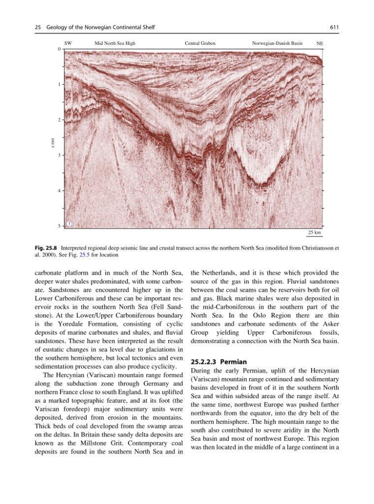
Fig. 25.8 Interpreted regional deep seismic line and crustal transect across the northern North Sea (modified from Christiansson et
al. 2000). See Fig. 25.5 for location
25 Geology of the Norwegian Continental Shelf
611
deeper water shales predominated, with some carbonate. Sandstones are encountered higher up in the
Lower Carboniferous and these can be important reservoir rocks in the southern North Sea (Fell Sandstone). At the Lower/Upper Carboniferous boundary
is the Yoredale Formation, consisting of cyclic
deposits of marine carbonates and shales, and fluvial
sandstones. These have been interpreted as the result
of eustatic changes in sea level due to glaciations in
the southern hemisphere, but local tectonics and even
sedimentation processes can also produce cyclicity.
The Hercynian (Variscan) mountain range formed
along the subduction zone through Germany and
northern France close to south England. It was uplifted
as a marked topographic feature, and at its foot (the
Variscan foredeep) major sedimentary units were
deposited, derived from erosion in the mountains.
Thick beds of coal developed from the swamp areas
on the deltas. In Britain these sandy delta deposits are
known as the Millstone Grit. Contemporary coal
deposits are found in the southern North Sea and in
the Netherlands, and it is these which provided the
source of the gas in this region. Fluvial sandstones
between the coal seams can be reservoirs both for oil
and gas. Black marine shales were also deposited in
the mid-Carboniferous in the southern part of the
North Sea. In the Oslo Region there are thin
sandstones and carbonate sediments of the Asker
Group yielding Upper Carboniferous fossils,
demonstrating a connection with the North Sea basin.
25.2.2.3 Permian
During the early Permian, uplift of the Hercynian
(Variscan) mountain range continued and sedimentary
basins developed in front of it in the southern North
Sea and within subsided areas of the range itself. At
the same time, northwest Europe was pushed farther
northwards from the equator, into the dry belt of the
northern hemisphere. The high mountain range to the
south also contributed to severe aridity in the North
Sea basin and most of northwest Europe. This region
was then located in the middle of a large continent in a
1
0
2
3
4
5
25 km
s
twt
SW
NE
Norwegian-Danish Basin
Central Graben
Mid North Sea High
3
Fig. 25.8 Interpreted regional deep seismic line and crustal transect across the northern North Sea (modified from Christiansson et
al. 2000). See Fig. 25.5 for location
25 Geology of the Norwegian Continental Shelf
611