

Barents Sea (Johan Castberg and Gohta/Alta) have
added considerable oil resources which will contribute to substantial production in years to come.
Technological advances have led to development
of discoveries in areas of great water depth and far
from shore. The technological advances have also
made a higher proportion of the resources profitable
to recover. On average, fields on the Norwegian shelf
have a recovery factor of 46% for oil. This is high
compared with oil provinces in other parts of the
world. Continuous research and development of technology are required to raise this further.
Significant volumes remain to be found and produced on the Norwegian continental shelf. About
40–50% of the estimated oil and gas reserves have so
far been produced. The reserves will depend on future
oil and gas prices and on environmental restrictions. It
may still be possible to make large discoveries in less
explored areas, such as in deep waters in the Norwegian
Sea, in the Barents Sea and in areas that are not yet
open. Oil production reached its peak in 2000–2001, but
gas production is still increasing. For more facts about
the petroleum activity on the Norwegian shelf see http://
www.npd.no/en/Publications/Resource-Reports/2014/.
25.2 North Sea
25.2.1 Structure
The North Sea is an example of an intracratonic
basin; that is to say a basin which lies on continental
crust. The prerequisite for forming major sedimentary basins on continental crust is that the crust (and
mantle lithosphere) is thinned, resulting in subsidence to maintain isostatic equilibrium. The North
Sea has been subjected to periods of stretching/thinning and subsidence during late Carboniferous,
Permian-Early Triassic and Late Jurassic times.
Each rift phase was followed by a thermal cooling
stage, characterised by regional subsidence in the
basin areas.
The Northern North Sea province is dominated by
the Viking Graben, which continues into the Sogn
Graben towards the north (Fig. 25.5). These grabens
are flanked by the East Shetland Basin and the Tampen
Spur to the west, and the Horda Platform to the east
(Figs. 25.6 and 25.7). These are Jurassic-Cretaceous
features, and the main crustal thinning took place in
the late Middle to Late Jurassic, followed by thermal
–5 °
0°
5°
10°
15°
20°
55 °
60 °
65 °
70 °
7 5 °
8 0 °
–5 °
0°
5°
10°
15°
20°
55 °
60 °
65 °
70 °
7 5 °
8 0 ˚
–5 °
0°
5°
10°
15°
20°
55 °
60 °
65 °
70 °
7 5 °
8 0 °
E ur ek an O ro ge ny
(n ot re st or ed )
Present
a
b
c
J M M C
J M
M
C
Chron 13 (c. 33 Ma)
Breakup (c. 55 Ma)
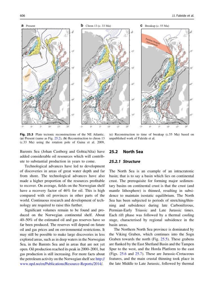
Fig. 25.3 Plate tectonic reconstructions of the NE Atlantic.
(a) Present (same as Fig. 25.2), (b) Reconstruction to chron 13
(c.33 Ma) using the rotation pole of Gaina et al. 2009,
(c) Reconstruction to time of breakup (c.55 Ma) based on
unpublished work of Faleide et al.
606
J.I. Faleide et al.
added considerable oil resources which will contribute to substantial production in years to come.
Technological advances have led to development
of discoveries in areas of great water depth and far
from shore. The technological advances have also
made a higher proportion of the resources profitable
to recover. On average, fields on the Norwegian shelf
have a recovery factor of 46% for oil. This is high
compared with oil provinces in other parts of the
world. Continuous research and development of technology are required to raise this further.
Significant volumes remain to be found and produced on the Norwegian continental shelf. About
40–50% of the estimated oil and gas reserves have so
far been produced. The reserves will depend on future
oil and gas prices and on environmental restrictions. It
may still be possible to make large discoveries in less
explored areas, such as in deep waters in the Norwegian
Sea, in the Barents Sea and in areas that are not yet
open. Oil production reached its peak in 2000–2001, but
gas production is still increasing. For more facts about
the petroleum activity on the Norwegian shelf see http://
www.npd.no/en/Publications/Resource-Reports/2014/.
25.2 North Sea
25.2.1 Structure
The North Sea is an example of an intracratonic
basin; that is to say a basin which lies on continental
crust. The prerequisite for forming major sedimentary basins on continental crust is that the crust (and
mantle lithosphere) is thinned, resulting in subsidence to maintain isostatic equilibrium. The North
Sea has been subjected to periods of stretching/thinning and subsidence during late Carboniferous,
Permian-Early Triassic and Late Jurassic times.
Each rift phase was followed by a thermal cooling
stage, characterised by regional subsidence in the
basin areas.
The Northern North Sea province is dominated by
the Viking Graben, which continues into the Sogn
Graben towards the north (Fig. 25.5). These grabens
are flanked by the East Shetland Basin and the Tampen
Spur to the west, and the Horda Platform to the east
(Figs. 25.6 and 25.7). These are Jurassic-Cretaceous
features, and the main crustal thinning took place in
the late Middle to Late Jurassic, followed by thermal
–5 °
0°
5°
10°
15°
20°
55 °
60 °
65 °
70 °
7 5 °
8 0 °
–5 °
0°
5°
10°
15°
20°
55 °
60 °
65 °
70 °
7 5 °
8 0 ˚
–5 °
0°
5°
10°
15°
20°
55 °
60 °
65 °
70 °
7 5 °
8 0 °
E ur ek an O ro ge ny
(n ot re st or ed )
Present
a
b
c
J M M C
J M
M
C
Chron 13 (c. 33 Ma)
Breakup (c. 55 Ma)
Fig. 25.3 Plate tectonic reconstructions of the NE Atlantic.
(a) Present (same as Fig. 25.2), (b) Reconstruction to chron 13
(c.33 Ma) using the rotation pole of Gaina et al. 2009,
(c) Reconstruction to time of breakup (c.55 Ma) based on
unpublished work of Faleide et al.
606
J.I. Faleide et al.