

important to repeat the horizontal positions both for
sources and receivers as accurately as possible; even a
misalignment of 20–30 m might significantly increase
the NRMS-level.
Such a plot can serve as a variogram, since it shows
the spread for each separation distance. Detailed studies have shown that the NRMS-level increases significantly in areas where the geology along the straight
line between the source and receiver is complex. From
Fig. 19.12 we see that the NRMS-value for a shot
separation distance of 40 m might vary between 20
and 80% and a significant portion of this spread is
attributed to variation in geology. This means that it
is not straightforward to compare NRMS-levels
between various fields, since the geological setting
might be very different. Still, NRMS-levels are frequently used, since they provide a simple, quantitative
measure. It is also important to note that the NRMSlevel is frequency dependent, so the frequency band
used in the data analysis should be given.
During the last two decades the focus on source
and receiver positioning accuracy has lead to a significant improvement in the repeatability of 4D seismic data. Some of this is also attributed to better
processing of time-lapse seismic data. This trend is
sketched in Fig. 19.13. Today the global average
NRMS-level is around 20–30%. It is expected that
this trend will continue, though not at the same rate
because the non-repeatable factors that need to be
tackled to get beyond 20–30% are more difficult. In
particular, rough weather conditions will represent a
major hurdle.
19.6 Fixed Receiver Cables
For marine seismic data, there are several ways to
control the source and receiver positions.
WesternGeco developed their Q-marine system,
where the streamers can also be steered in the horizontal direction (x and y). This means that it is possible to
repeat the receiver positions by steering the streamers
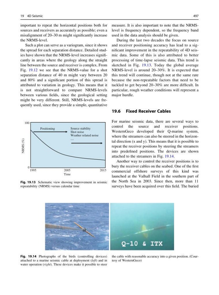
into predefined positions. The devices are shown
attached to the streamers in Fig. 19.14.
Another way to control the receiver positions is to
bury the receiver cables on the seabed. One of the first
commercial offshore surveys of this kind was
launched at the Valhall Field in the southern part of
the North Sea in 2003. Since then, more than 11
surveys have been acquired over this field. The buried
100
Source stability
Positioning
Shot noise
Weather related noise
....
NRMS (%)
0
1995
2005
2015
Time
Fig. 19.13 Schematic view showing improvement in seismic
repeatability (NRMS) versus calendar time
Fig. 19.14 Photographs of the birds (controlling devices)
attached to a marine seismic cable at deployment (left) and in
water operation (right). These devices make it possible to steer
the cable with reasonable accuracy into a given position. (Courtesy of WesternGeco)
19 4D Seismic
497
sources and receivers as accurately as possible; even a
misalignment of 20–30 m might significantly increase
the NRMS-level.
Such a plot can serve as a variogram, since it shows
the spread for each separation distance. Detailed studies have shown that the NRMS-level increases significantly in areas where the geology along the straight
line between the source and receiver is complex. From
Fig. 19.12 we see that the NRMS-value for a shot
separation distance of 40 m might vary between 20
and 80% and a significant portion of this spread is
attributed to variation in geology. This means that it
is not straightforward to compare NRMS-levels
between various fields, since the geological setting
might be very different. Still, NRMS-levels are frequently used, since they provide a simple, quantitative
measure. It is also important to note that the NRMSlevel is frequency dependent, so the frequency band
used in the data analysis should be given.
During the last two decades the focus on source
and receiver positioning accuracy has lead to a significant improvement in the repeatability of 4D seismic data. Some of this is also attributed to better
processing of time-lapse seismic data. This trend is
sketched in Fig. 19.13. Today the global average
NRMS-level is around 20–30%. It is expected that
this trend will continue, though not at the same rate
because the non-repeatable factors that need to be
tackled to get beyond 20–30% are more difficult. In
particular, rough weather conditions will represent a
major hurdle.
19.6 Fixed Receiver Cables
For marine seismic data, there are several ways to
control the source and receiver positions.
WesternGeco developed their Q-marine system,
where the streamers can also be steered in the horizontal direction (x and y). This means that it is possible to
repeat the receiver positions by steering the streamers
into predefined positions. The devices are shown
attached to the streamers in Fig. 19.14.
Another way to control the receiver positions is to
bury the receiver cables on the seabed. One of the first
commercial offshore surveys of this kind was
launched at the Valhall Field in the southern part of
the North Sea in 2003. Since then, more than 11
surveys have been acquired over this field. The buried
100
Source stability
Positioning
Shot noise
Weather related noise
....
NRMS (%)
0
1995
2005
2015
Time
Fig. 19.13 Schematic view showing improvement in seismic
repeatability (NRMS) versus calendar time
Fig. 19.14 Photographs of the birds (controlling devices)
attached to a marine seismic cable at deployment (left) and in
water operation (right). These devices make it possible to steer
the cable with reasonable accuracy into a given position. (Courtesy of WesternGeco)
19 4D Seismic
497