

subsurface increases with depth. The rate at which it
does so is called the geothermal gradient (g G ), or
simply geotherm. The first step involved in determining temperature at a particular depth is to determine
the geotherm of the region.
Low thermal conductivity rocks, such as shale,
act as a thermal insulator and have a large temperature gradient across them, while high thermal conductivity rocks, such as salt, permit the conduction
of heat efficiently and have a small temperature
gradient across them. Geothermal gradient is commonly expressed in degrees celsius per 100 m
(
C/100 m). If the geothermal gradient of an area
is not known, then it can be determined by the
following formula:
g G ¼ BHT À Tms=TD
ð
Þ Â 100
(16.1)
where BHT is the bottom hole temperature, TD is the
total depth and T ms is the mean surface temperature.
Typical geotherms for reservoirs are about 20–35
C/
km, although significantly higher values (up to 85
C/
km) can be found in tectonically active areas, and
lower ones (0.05
C/km) in stable continental
platforms. Once the geothermal gradient has been
established, it is possible to determine the temperature for a particular depth (D) using the following
formula. This is often referred to as formation temperature (T f ).
T f ¼ Tms þ g G D=100
ð
Þ
½
(16.2)
16.5.1.2 Uses of Temperature Log
Temperature logs have many applications, with the
most common being to identify zones producing or
accumulating fluid, to evaluate a cement or hydraulic
fracture treatment, and to locate lost circulation zones
and casing leaks. Geothermal gradients in sedimentary
basins are extremely important for the calculations
necessary for predicting kerogen maturation, detection
of fluid movement, subsurface pressures, and for the
general modelling of basin subsidence. Since temperature takes time to dissipate, a temperature log tends to
reflect the behaviour of a well over a longer time
period than other measurements.
16.5.1.3 Uncertainties of Temperature Log
Temperature measurements made during drilling
(MWD and LWD) consistently underestimate the formation temperature because drilling mud is being
circulated. Temperature measurements made on
wireline logs sometime after the drilling fluid circulation has stopped also underestimate the formation
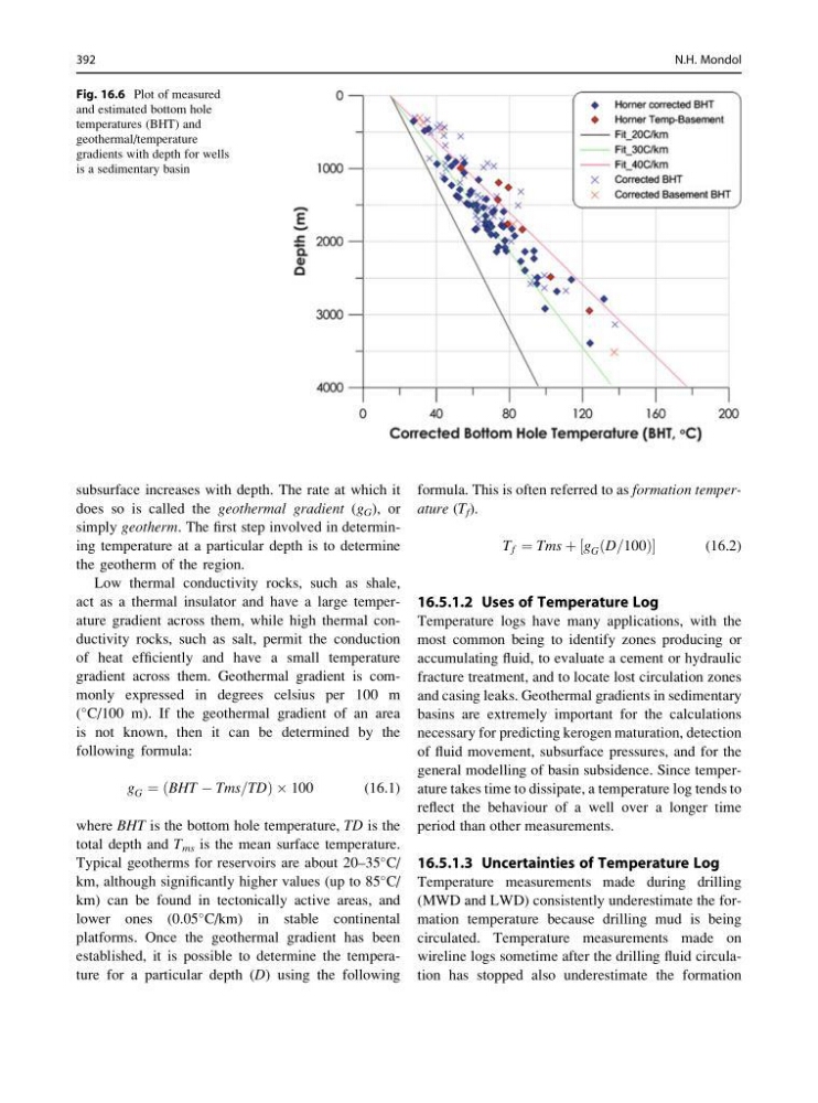
Fig. 16.6 Plot of measured
and estimated bottom hole
temperatures (BHT) and
geothermal/temperature
gradients with depth for wells
is a sedimentary basin
392
N.H. Mondol
does so is called the geothermal gradient (g G ), or
simply geotherm. The first step involved in determining temperature at a particular depth is to determine
the geotherm of the region.
Low thermal conductivity rocks, such as shale,
act as a thermal insulator and have a large temperature gradient across them, while high thermal conductivity rocks, such as salt, permit the conduction
of heat efficiently and have a small temperature
gradient across them. Geothermal gradient is commonly expressed in degrees celsius per 100 m
(
C/100 m). If the geothermal gradient of an area
is not known, then it can be determined by the
following formula:
g G ¼ BHT À Tms=TD
ð
Þ Â 100
(16.1)
where BHT is the bottom hole temperature, TD is the
total depth and T ms is the mean surface temperature.
Typical geotherms for reservoirs are about 20–35
C/
km, although significantly higher values (up to 85
C/
km) can be found in tectonically active areas, and
lower ones (0.05
C/km) in stable continental
platforms. Once the geothermal gradient has been
established, it is possible to determine the temperature for a particular depth (D) using the following
formula. This is often referred to as formation temperature (T f ).
T f ¼ Tms þ g G D=100
ð
Þ
½
(16.2)
16.5.1.2 Uses of Temperature Log
Temperature logs have many applications, with the
most common being to identify zones producing or
accumulating fluid, to evaluate a cement or hydraulic
fracture treatment, and to locate lost circulation zones
and casing leaks. Geothermal gradients in sedimentary
basins are extremely important for the calculations
necessary for predicting kerogen maturation, detection
of fluid movement, subsurface pressures, and for the
general modelling of basin subsidence. Since temperature takes time to dissipate, a temperature log tends to
reflect the behaviour of a well over a longer time
period than other measurements.
16.5.1.3 Uncertainties of Temperature Log
Temperature measurements made during drilling
(MWD and LWD) consistently underestimate the formation temperature because drilling mud is being
circulated. Temperature measurements made on
wireline logs sometime after the drilling fluid circulation has stopped also underestimate the formation
Fig. 16.6 Plot of measured
and estimated bottom hole
temperatures (BHT) and
geothermal/temperature
gradients with depth for wells
is a sedimentary basin
392
N.H. Mondol