

direction. This may cause fracturing and the release of
carbonate slabs from these submarine slopes. A 2 km
thick carbonate sequence represents a load (stress) of
about 40–50 MPa assuming an average density of
2.0–2.5 g/cm. In the water column at the same depth
the water load is only 20 MPa and the differential stress
is then about 25 MPa.
When the Bahamas Bank, and other carbonate
banks in the world, was exposed by the >100 m sea
level drop during the glacial periods, it became
lithified by percolating meteoric water which
dissolved the aragonite and precipitated it as calcite
cement. The loose carbonate sediments deposited over
the last 10–12,000 years are not more than 3–4 m thick
and rest unconformably on well-cemented, Pleistocene carbonate rocks.
Sedimentation on the Bahamas Bank reflects the
climatic and bathymetric conditions. The temperature
of the surface water varies from about 20–22
C in
winter to 30–32
C in summer. Because of the limited
exchange between water overlying the Bahamas platform and the surrounding ocean, the water in the
interior of the Bank, particularly in summer, has a
higher salinity than normal – up to 40‰. In winter
the salinity is reduced by increased water circulation
with the surrounding ocean, by rainwater and by
Reef
Coralgal
Oolitic
Grapestone
Oolite
Pellet mud
Mud
Lithofacies
0
2 0 k m
Andros Island
New Providence
No rth we st Pr ov ide nc e Ch an ne l
T o n g u e o f th e O c e a n
Joulters Cays
Berry Islands
Bimini Islands
20 m
0
0
2
0 m
200 m
b
100
0
k m
Little Bahama Bank
200 m
200
m
2 0 0 m
20
0
m
0
2
0 m
20 0 m
Grand Bahama
P r o v id e n c e C h a n n e l
o
g
o
O
n
T
n
ue
f
th
e
ce
a
E x u m a S o u n d
G
r
e
a
t
B
a
h
a
m
a
B
a
n
k
N ic h o la s C h a n n el
S
a
n
ta
re
n
C
h
a
n
n
el
F l o r i d a
S t r a i t s
Cay Sal Bank
Great Abaco
Eleuthera
Cat Island
New providence
Bimini Islands
Great Ragged Island
Long Island
Great Exuma
Florida
Cuba
80°
78°
76°
26°
24°
22°
2 m
00
Andros
Island
25°
24°
26°
78°
79°
Oolitic
facies
Grapestone
facies
Mud facies
Grapestone
facies
Oolitic
facies
Reef
Coralgal
facies
Coralgal
facies
Sea level
Barrier rim
Shelf lagoon
Windward
lagoon
W
E
a
c
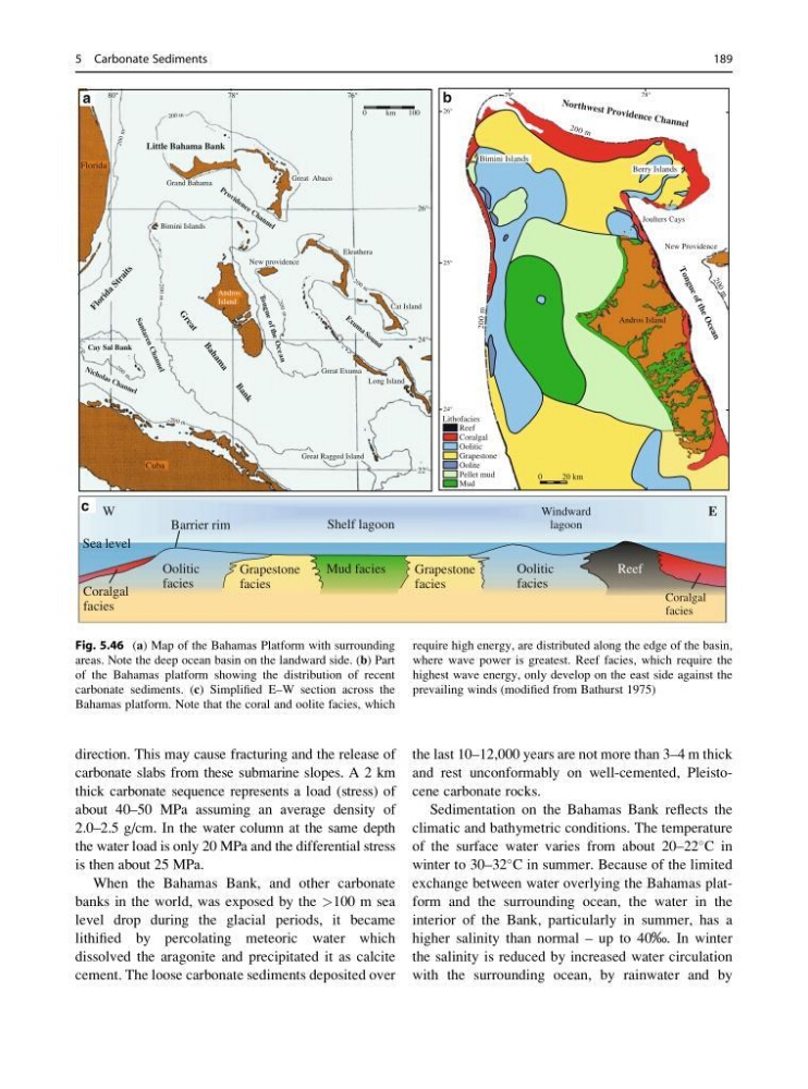
Fig. 5.46 (a) Map of the Bahamas Platform with surrounding
areas. Note the deep ocean basin on the landward side. (b) Part
of the Bahamas platform showing the distribution of recent
carbonate sediments. (c) Simplified E–W section across the
Bahamas platform. Note that the coral and oolite facies, which
require high energy, are distributed along the edge of the basin,
where wave power is greatest. Reef facies, which require the
highest wave energy, only develop on the east side against the
prevailing winds (modified from Bathurst 1975)
5 Carbonate Sediments
189
carbonate slabs from these submarine slopes. A 2 km
thick carbonate sequence represents a load (stress) of
about 40–50 MPa assuming an average density of
2.0–2.5 g/cm. In the water column at the same depth
the water load is only 20 MPa and the differential stress
is then about 25 MPa.
When the Bahamas Bank, and other carbonate
banks in the world, was exposed by the >100 m sea
level drop during the glacial periods, it became
lithified by percolating meteoric water which
dissolved the aragonite and precipitated it as calcite
cement. The loose carbonate sediments deposited over
the last 10–12,000 years are not more than 3–4 m thick
and rest unconformably on well-cemented, Pleistocene carbonate rocks.
Sedimentation on the Bahamas Bank reflects the
climatic and bathymetric conditions. The temperature
of the surface water varies from about 20–22
C in
winter to 30–32
C in summer. Because of the limited
exchange between water overlying the Bahamas platform and the surrounding ocean, the water in the
interior of the Bank, particularly in summer, has a
higher salinity than normal – up to 40‰. In winter
the salinity is reduced by increased water circulation
with the surrounding ocean, by rainwater and by
Reef
Coralgal
Oolitic
Grapestone
Oolite
Pellet mud
Mud
Lithofacies
0
2 0 k m
Andros Island
New Providence
No rth we st Pr ov ide nc e Ch an ne l
T o n g u e o f th e O c e a n
Joulters Cays
Berry Islands
Bimini Islands
20 m
0
0
2
0 m
200 m
b
100
0
k m
Little Bahama Bank
200 m
200
m
2 0 0 m
20
0
m
0
2
0 m
20 0 m
Grand Bahama
P r o v id e n c e C h a n n e l
o
g
o
O
n
T
n
ue
f
th
e
ce
a
E x u m a S o u n d
G
r
e
a
t
B
a
h
a
m
a
B
a
n
k
N ic h o la s C h a n n el
S
a
n
ta
re
n
C
h
a
n
n
el
F l o r i d a
S t r a i t s
Cay Sal Bank
Great Abaco
Eleuthera
Cat Island
New providence
Bimini Islands
Great Ragged Island
Long Island
Great Exuma
Florida
Cuba
80°
78°
76°
26°
24°
22°
2 m
00
Andros
Island
25°
24°
26°
78°
79°
Oolitic
facies
Grapestone
facies
Mud facies
Grapestone
facies
Oolitic
facies
Reef
Coralgal
facies
Coralgal
facies
Sea level
Barrier rim
Shelf lagoon
Windward
lagoon
W
E
a
c
Fig. 5.46 (a) Map of the Bahamas Platform with surrounding
areas. Note the deep ocean basin on the landward side. (b) Part
of the Bahamas platform showing the distribution of recent
carbonate sediments. (c) Simplified E–W section across the
Bahamas platform. Note that the coral and oolite facies, which
require high energy, are distributed along the edge of the basin,
where wave power is greatest. Reef facies, which require the
highest wave energy, only develop on the east side against the
prevailing winds (modified from Bathurst 1975)
5 Carbonate Sediments
189