

5.7.3.2 Reef and Carbonate Platforms
Surrounded by Deep Oceans
Volcanic sea mounts reaching up to sea level are ideal
places for carbonate sedimentation since all the clastic
sediment will be trapped in the surrounding deeper
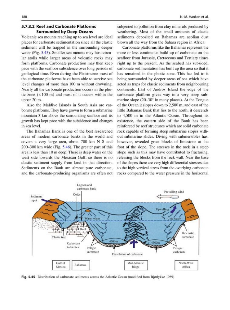
water (Fig. 5.45). Smaller sea mounts may host circular atolls while larger areas of volcanic rocks may
form platforms. Carbonate production may then keep
pace with the seafloor subsidence over long periods of
geological time. Even during the Pleistocene most of
the carbonate platforms have been able to survive sea
level changes of more than 100 m without drowning.
Nearly all the carbonate production occurs in the photic zone (<100 m) and most of it occurs within the
upper 20 m.
Also the Maldive Islands in South Asia are carbonate platforms. They have grown to form a submarine
mountain 3 km above the surrounding seafloor and its
growth has kept pace with the subsidence and changes
in sea level.
The Bahamas Bank is one of the best researched
areas of modern carbonate banks in the world and
covers a very large area, about 700 km N–S and
200–300 km wide (Fig. 5.46). The greater part of this
area is less than 10 m deep. There is deep water on the
west side towards the Mexican Gulf, so there is no
clastic sediment supply from land in that direction.
Sediments on the Bank are almost pure carbonate,
and the carbonate-producing organisms are often not
subjected to pollution from clay minerals produced by
weathering. Most of the small amounts of clastic
sediments deposited on Bahamas are aeolian dust
blown all the way from the Sahara region in Africa.
Carbonate platforms like the Bahamas represent the
more or less continuous build-up of carbonate on the
seafloor from Jurassic, Cretaceous and Tertiary times
right up to the present. As the seabed has subsided,
carbonate sedimentation has built up the area so that it
has remained in the photic zone. This has led to it
being surrounded by deeper areas of sea which have
acted as traps for clastic sediments from neighbouring
continents. East of Andros Island the edge of the
carbonate platform gives way to a very steep submarine slope (20–30
in many places). At the Tongue
of the Ocean it slopes down to 2,500 m, and east of the
little Bahamas Bank that lies to the north, it descends
to 4,500 m in the Atlantic Ocean. Throughout its
existence, the eastern side of the Bank has been
reinforced by reef structures which are solid carbonate
rock capable of forming steep submarine slopes without submarine slides. Diving with submersibles has,
however, revealed great blocks of limestone at the
foot of the slope. The stresses in the rock in a steep
slope such as this may have contributed to fracturing,
releasing the blocks from the rock wall. Near the base
of the slopes there are very high differential stresses due
to the high vertical stress from the overlying carbonate
rocks compared to the water pressure in the horizontal
Ooids
Lagoon and
carbonate bank
Sediment
input
Prevailing wind
Bioclastic
carbonate
Dissolution of carbonate
Reef
Clastic trap
Carbonate
turbidites
Gulf of
Mexico
Bahamas
Mid-Atlantic
Ridge
North-West
Africa
Pelagic
carbonate
Pelagic
carbonate
Warm water
Upwelling
Cold water
4500m
4500m
Fig. 5.45 Distribution of carbonate sediments across the Atlantic Ocean (modified from Bjørlykke 1989)
188
N.-M. Hanken et al.
Surrounded by Deep Oceans
Volcanic sea mounts reaching up to sea level are ideal
places for carbonate sedimentation since all the clastic
sediment will be trapped in the surrounding deeper
water (Fig. 5.45). Smaller sea mounts may host circular atolls while larger areas of volcanic rocks may
form platforms. Carbonate production may then keep
pace with the seafloor subsidence over long periods of
geological time. Even during the Pleistocene most of
the carbonate platforms have been able to survive sea
level changes of more than 100 m without drowning.
Nearly all the carbonate production occurs in the photic zone (<100 m) and most of it occurs within the
upper 20 m.
Also the Maldive Islands in South Asia are carbonate platforms. They have grown to form a submarine
mountain 3 km above the surrounding seafloor and its
growth has kept pace with the subsidence and changes
in sea level.
The Bahamas Bank is one of the best researched
areas of modern carbonate banks in the world and
covers a very large area, about 700 km N–S and
200–300 km wide (Fig. 5.46). The greater part of this
area is less than 10 m deep. There is deep water on the
west side towards the Mexican Gulf, so there is no
clastic sediment supply from land in that direction.
Sediments on the Bank are almost pure carbonate,
and the carbonate-producing organisms are often not
subjected to pollution from clay minerals produced by
weathering. Most of the small amounts of clastic
sediments deposited on Bahamas are aeolian dust
blown all the way from the Sahara region in Africa.
Carbonate platforms like the Bahamas represent the
more or less continuous build-up of carbonate on the
seafloor from Jurassic, Cretaceous and Tertiary times
right up to the present. As the seabed has subsided,
carbonate sedimentation has built up the area so that it
has remained in the photic zone. This has led to it
being surrounded by deeper areas of sea which have
acted as traps for clastic sediments from neighbouring
continents. East of Andros Island the edge of the
carbonate platform gives way to a very steep submarine slope (20–30
in many places). At the Tongue
of the Ocean it slopes down to 2,500 m, and east of the
little Bahamas Bank that lies to the north, it descends
to 4,500 m in the Atlantic Ocean. Throughout its
existence, the eastern side of the Bank has been
reinforced by reef structures which are solid carbonate
rock capable of forming steep submarine slopes without submarine slides. Diving with submersibles has,
however, revealed great blocks of limestone at the
foot of the slope. The stresses in the rock in a steep
slope such as this may have contributed to fracturing,
releasing the blocks from the rock wall. Near the base
of the slopes there are very high differential stresses due
to the high vertical stress from the overlying carbonate
rocks compared to the water pressure in the horizontal
Ooids
Lagoon and
carbonate bank
Sediment
input
Prevailing wind
Bioclastic
carbonate
Dissolution of carbonate
Reef
Clastic trap
Carbonate
turbidites
Gulf of
Mexico
Bahamas
Mid-Atlantic
Ridge
North-West
Africa
Pelagic
carbonate
Pelagic
carbonate
Warm water
Upwelling
Cold water
4500m
4500m
Fig. 5.45 Distribution of carbonate sediments across the Atlantic Ocean (modified from Bjørlykke 1989)
188
N.-M. Hanken et al.