

runoff from Andros Island. Since the prevailing winds
are from the east, where we also have deep water,
wave energy is strongest on the east side of the platform. We therefore find reef facies along the east side
of the platform, but not along the west side. However,
corals and algae (coralalgal facies) are also present on
the west side of the bank, but they do not form proper
reef structures there.
Oolite banks form in shallow areas with constant
wave agitation and strong tidal currents. In water
deeper than the normal wave base, we find large
bedforms of oolites and other carbonate sand which
are only mobilised by major hurricanes. Dunes or
sandwaves with a wavelength of about 50–100 m,
mapped from aerial photograph surveys, show no
sign of having moved in 20–30 years. Extensive
areas of seabed where the wave energy is less than
on the oolite banks are covered with algal mats. The
algal threads forming this mat help to protect the
sediments from erosion, inhibiting bed transport and
current ripple development. They also contribute,
through photosynthesis, to the creation of a chemical
environment with low CO 2 concentrations which
may cause local precipitation of carbonate within the
mat.
In the middle areas, sedimentation of carbonate
mud facies prevails. This is because wave energy is
reduced along the edge of the Bank, and the whole of
the shallow area within is a low-energy environment.
Tidal currents are also reduced in the shallow water
because most of the tidal energy is dissipated in
overcoming the friction against the bottom and the
tidal range drops from about 0.7–0.8 m along the
edge to practically zero in the centre. The most important sediment transport mechanism is probably
hurricanes. These can mobilise normally stable
sediments, forming large dunes or sandwaves. Large
oolite banks may migrate along the edge of the platform, and storms also inflict some erosion of the reefs.
Towards the centre of the platform wind stress can
cause changes in sea level of up to 3 m, and create
great turbulence which brings large quantities of mud
and sand into suspension. Some of this material will be
transported off the platform and down the submarine
slopes.
The areas west of Andros Island, which are the
shallowest and best-protected against storms from
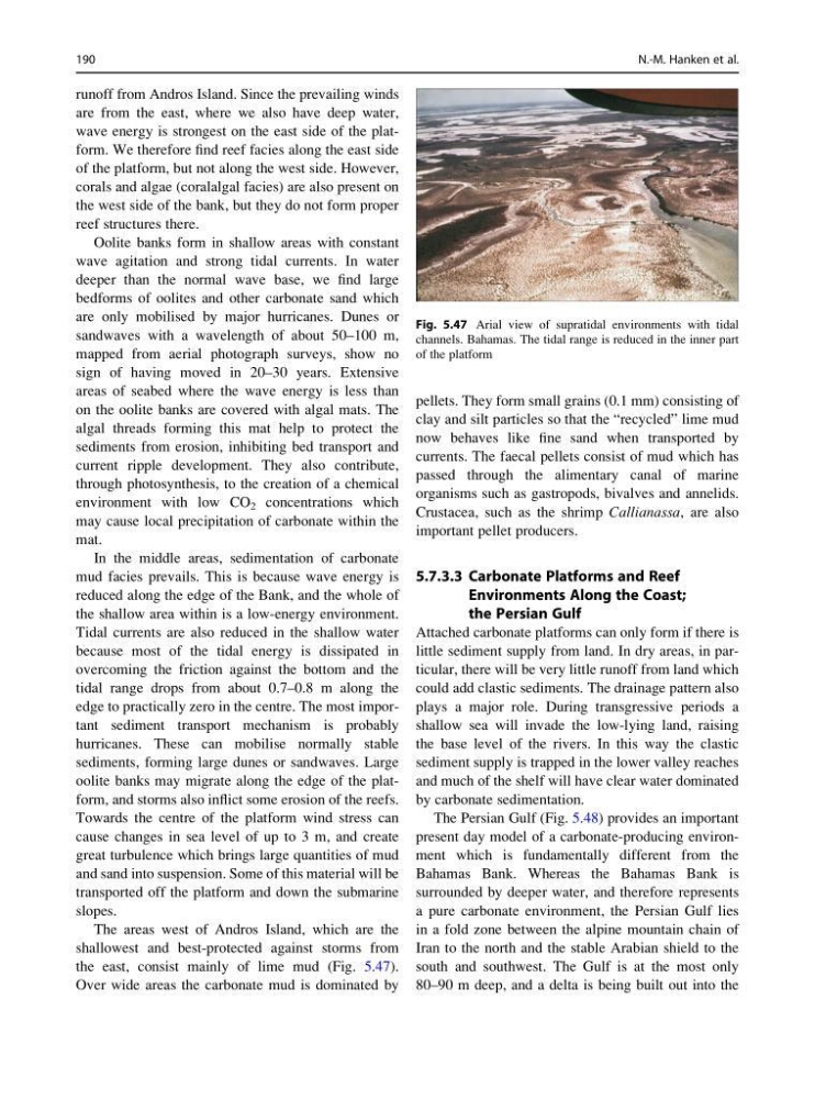
the east, consist mainly of lime mud (Fig. 5.47).
Over wide areas the carbonate mud is dominated by
pellets. They form small grains (0.1 mm) consisting of
clay and silt particles so that the “recycled” lime mud
now behaves like fine sand when transported by
currents. The faecal pellets consist of mud which has
passed through the alimentary canal of marine
organisms such as gastropods, bivalves and annelids.
Crustacea, such as the shrimp Callianassa, are also
important pellet producers.
5.7.3.3 Carbonate Platforms and Reef
Environments Along the Coast;
the Persian Gulf
Attached carbonate platforms can only form if there is
little sediment supply from land. In dry areas, in particular, there will be very little runoff from land which
could add clastic sediments. The drainage pattern also
plays a major role. During transgressive periods a
shallow sea will invade the low-lying land, raising
the base level of the rivers. In this way the clastic
sediment supply is trapped in the lower valley reaches
and much of the shelf will have clear water dominated
by carbonate sedimentation.
The Persian Gulf (Fig. 5.48) provides an important
present day model of a carbonate-producing environment which is fundamentally different from the
Bahamas Bank. Whereas the Bahamas Bank is
surrounded by deeper water, and therefore represents
a pure carbonate environment, the Persian Gulf lies
in a fold zone between the alpine mountain chain of
Iran to the north and the stable Arabian shield to the
south and southwest. The Gulf is at the most only
80–90 m deep, and a delta is being built out into the
Fig. 5.47 Arial view of supratidal environments with tidal
channels. Bahamas. The tidal range is reduced in the inner part
of the platform
190
N.-M. Hanken et al.
are from the east, where we also have deep water,
wave energy is strongest on the east side of the platform. We therefore find reef facies along the east side
of the platform, but not along the west side. However,
corals and algae (coralalgal facies) are also present on
the west side of the bank, but they do not form proper
reef structures there.
Oolite banks form in shallow areas with constant
wave agitation and strong tidal currents. In water
deeper than the normal wave base, we find large
bedforms of oolites and other carbonate sand which
are only mobilised by major hurricanes. Dunes or
sandwaves with a wavelength of about 50–100 m,
mapped from aerial photograph surveys, show no
sign of having moved in 20–30 years. Extensive
areas of seabed where the wave energy is less than
on the oolite banks are covered with algal mats. The
algal threads forming this mat help to protect the
sediments from erosion, inhibiting bed transport and
current ripple development. They also contribute,
through photosynthesis, to the creation of a chemical
environment with low CO 2 concentrations which
may cause local precipitation of carbonate within the
mat.
In the middle areas, sedimentation of carbonate
mud facies prevails. This is because wave energy is
reduced along the edge of the Bank, and the whole of
the shallow area within is a low-energy environment.
Tidal currents are also reduced in the shallow water
because most of the tidal energy is dissipated in
overcoming the friction against the bottom and the
tidal range drops from about 0.7–0.8 m along the
edge to practically zero in the centre. The most important sediment transport mechanism is probably
hurricanes. These can mobilise normally stable
sediments, forming large dunes or sandwaves. Large
oolite banks may migrate along the edge of the platform, and storms also inflict some erosion of the reefs.
Towards the centre of the platform wind stress can
cause changes in sea level of up to 3 m, and create
great turbulence which brings large quantities of mud
and sand into suspension. Some of this material will be
transported off the platform and down the submarine
slopes.
The areas west of Andros Island, which are the
shallowest and best-protected against storms from
the east, consist mainly of lime mud (Fig. 5.47).
Over wide areas the carbonate mud is dominated by
pellets. They form small grains (0.1 mm) consisting of
clay and silt particles so that the “recycled” lime mud
now behaves like fine sand when transported by
currents. The faecal pellets consist of mud which has
passed through the alimentary canal of marine
organisms such as gastropods, bivalves and annelids.
Crustacea, such as the shrimp Callianassa, are also
important pellet producers.
5.7.3.3 Carbonate Platforms and Reef
Environments Along the Coast;
the Persian Gulf
Attached carbonate platforms can only form if there is
little sediment supply from land. In dry areas, in particular, there will be very little runoff from land which
could add clastic sediments. The drainage pattern also
plays a major role. During transgressive periods a
shallow sea will invade the low-lying land, raising
the base level of the rivers. In this way the clastic
sediment supply is trapped in the lower valley reaches
and much of the shelf will have clear water dominated
by carbonate sedimentation.
The Persian Gulf (Fig. 5.48) provides an important
present day model of a carbonate-producing environment which is fundamentally different from the
Bahamas Bank. Whereas the Bahamas Bank is
surrounded by deeper water, and therefore represents
a pure carbonate environment, the Persian Gulf lies
in a fold zone between the alpine mountain chain of
Iran to the north and the stable Arabian shield to the
south and southwest. The Gulf is at the most only
80–90 m deep, and a delta is being built out into the
Fig. 5.47 Arial view of supratidal environments with tidal
channels. Bahamas. The tidal range is reduced in the inner part
of the platform
190
N.-M. Hanken et al.