

482
Stratigraphic and Tectonic Controls on the Distribution and Architecture of Fluvial Oil and Gas Reservoirs
WASATCH
PLATEAU
UTAH I COLORADO
BOOK CLIFFS
FRONT RANGE UPLIFT
DENVER BASIN
metres
1000
� Nonmarine rocks
llllflil l!l Marine and coastal-battier
llll ll ll! !l ll sandstone
� Calcareous shale
� Limestone
800
600
400
200
0
c:J Marine shale and siltstone ---- Conglomerate
•• ··• Appro�imate lime line
Vert E�ag. "" 151
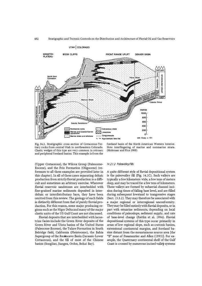
Fig. 14.2. Stratigraphic cross section of Cretaceous� Ter�
tiary rocks from central Utah to northeastern .colorado.
Clastic wedges of this type are very common in retroarc
and peripheral foreland basins. This example -is from the
(Upper Cretaceous), the Wilcox Group (PaleoceneEocene), and the Frio Formation (Oligocene) (references to all these examples are provided later in
this chapter). In all of these cases separating deltaic
production fr om strictly fluvial production is a difficult and sometimes an arbitrary exercise. Wherever
fluvial reservoir sandstones are interbedded with
fine-grained , marine sediments deposited in interdeltaic or interdistributary bays, they have been
omitted from this review. The geology of such fields
is distinctly different from that of purely fluvial production. For this reason, some major producing regions such as the Niger Delta and many of the major
clastic units of the US Gulf Coast are not discussed.
Fluvial deposits that are interbedded with lacustrine facies include the Green River deposits of the
Green River and Uinta basins of the United States
(Paleocene-pocene), the Tulare Formation in South
Belridge field, California (Pleistocene), the Bahia
Supergroup of the Rec6ncavo Basin (Jurassic� Lower
Cretaceous), and the fill of most of the Chinese
basins (Songliao, )iangsu, Ordos, Bohai Bay).
foreland basin of the North American Western Interior.
Note interfingering of marine and nonmarine strata.
(Molenaar and Rice 1988)
14.2.1.2 Pa/eovol/ey Fills
A quite different style of fluvial depositional system
is the paleovalley fill (Fig. !4.1C). Such valleys are
typically a few kilometers wide, a few tens of meters
deep, and may be traced for a few tens of kilometers.
These valleys are formed by subaerial channel incision during times of fal ling base level, and are filled
during subsequent lowstand to trangressive stages
(Sect. 13.3.2). They may therefore be associated with
a major regional or interregional unconformity.
They may be filled entirely with fluvial deposits, or in
part with estuarine sediments, depending on local
conditions of paleoslope1 sediment supply, and rate
of base-level change (Zaitlin et al. 1994). Fluvial
depositional systems of this type occur primarily in
areas of low regional slope, such as cratonic basins,
extensional continental margins, and fo reland basins distant from the mountainous source area [the
"B" zone of Posamentier and Allen (1993)]. For example, the Quaternary continental shelf of the Gulf
Coast is crossed by numerous incised valleY systems
Stratigraphic and Tectonic Controls on the Distribution and Architecture of Fluvial Oil and Gas Reservoirs
WASATCH
PLATEAU
UTAH I COLORADO
BOOK CLIFFS
FRONT RANGE UPLIFT
DENVER BASIN
metres
1000
� Nonmarine rocks
llllflil l!l Marine and coastal-battier
llll ll ll! !l ll sandstone
� Calcareous shale
� Limestone
800
600
400
200
0
c:J Marine shale and siltstone ---- Conglomerate
•• ··• Appro�imate lime line
Vert E�ag. "" 151
Fig. 14.2. Stratigraphic cross section of Cretaceous� Ter�
tiary rocks from central Utah to northeastern .colorado.
Clastic wedges of this type are very common in retroarc
and peripheral foreland basins. This example -is from the
(Upper Cretaceous), the Wilcox Group (PaleoceneEocene), and the Frio Formation (Oligocene) (references to all these examples are provided later in
this chapter). In all of these cases separating deltaic
production fr om strictly fluvial production is a difficult and sometimes an arbitrary exercise. Wherever
fluvial reservoir sandstones are interbedded with
fine-grained , marine sediments deposited in interdeltaic or interdistributary bays, they have been
omitted from this review. The geology of such fields
is distinctly different from that of purely fluvial production. For this reason, some major producing regions such as the Niger Delta and many of the major
clastic units of the US Gulf Coast are not discussed.
Fluvial deposits that are interbedded with lacustrine facies include the Green River deposits of the
Green River and Uinta basins of the United States
(Paleocene-pocene), the Tulare Formation in South
Belridge field, California (Pleistocene), the Bahia
Supergroup of the Rec6ncavo Basin (Jurassic� Lower
Cretaceous), and the fill of most of the Chinese
basins (Songliao, )iangsu, Ordos, Bohai Bay).
foreland basin of the North American Western Interior.
Note interfingering of marine and nonmarine strata.
(Molenaar and Rice 1988)
14.2.1.2 Pa/eovol/ey Fills
A quite different style of fluvial depositional system
is the paleovalley fill (Fig. !4.1C). Such valleys are
typically a few kilometers wide, a few tens of meters
deep, and may be traced for a few tens of kilometers.
These valleys are formed by subaerial channel incision during times of fal ling base level, and are filled
during subsequent lowstand to trangressive stages
(Sect. 13.3.2). They may therefore be associated with
a major regional or interregional unconformity.
They may be filled entirely with fluvial deposits, or in
part with estuarine sediments, depending on local
conditions of paleoslope1 sediment supply, and rate
of base-level change (Zaitlin et al. 1994). Fluvial
depositional systems of this type occur primarily in
areas of low regional slope, such as cratonic basins,
extensional continental margins, and fo reland basins distant from the mountainous source area [the
"B" zone of Posamentier and Allen (1993)]. For example, the Quaternary continental shelf of the Gulf
Coast is crossed by numerous incised valleY systems