

The Geometry of Fluvial Reservoirs
LEGEND
- Pre-Pleistocene surface
� Sangamonian fluvial-deltaic trends
1: : · \·:: _; ;::�::J Sangamonian beach and strandplain
.J. r Wisconsin river courses
- Late Wisconsinan shelf-margin delta
Late Wisconsinan-Holocene reefs
present shoreline
transgressed Holocene
beaches and
sand ridges
Sabine
b"""
0
50
100
1 5 0 km
483
QUA1ERNARY DEPOSill ONAL SYS1EMS,
1EXAS COASTAL PLAIN
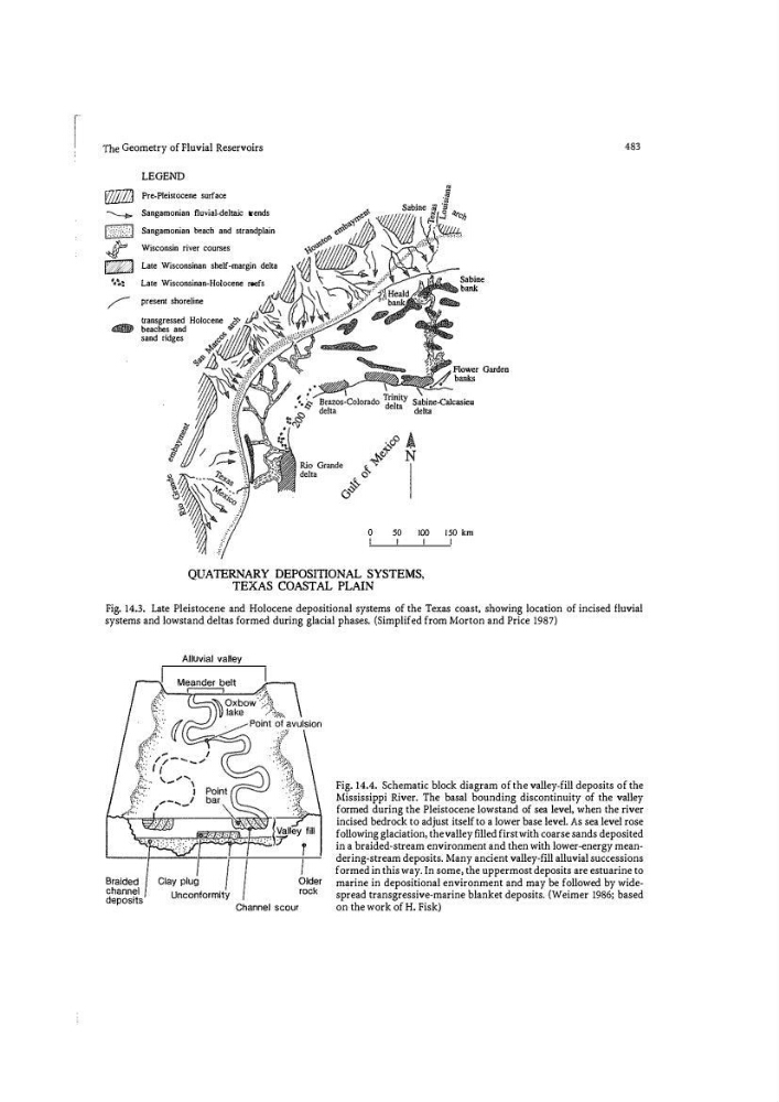
Fig. 14.3. Late Pleistocene and Holocene depositional systems of the Texas coast, showing location of incised fluvial
systems and lowstand deltas fo rmed during glacial phases. (Simplifed from Morton and Price 1987)
Alluvial valley
Older
rock
Channel scour
Fig. 14.4. Schematic block diagram of the valley�fill deposits of the
Mississippi River. The basal bounding discontinuity of the valley
formed during the Pleistocene lowstand of sea level, when the river
incised bedrock to adjust itself to a lower base level. As sea level rose
following glaciation, the valley fllled first with coarse sands deposited
in a braided-stream environment and then with lower-energy meandering-stream deposits. Many ancient valley-fill alluvial successions
formed in this way. In some, the uppermost deposits are estuarine to
marine in depositional environment and may be followed by widespread transgressive-marine blanket deposits. {Weimer 1986; based
on the work of H. Fisk)
LEGEND
- Pre-Pleistocene surface
� Sangamonian fluvial-deltaic trends
1: : · \·:: _; ;::�::J Sangamonian beach and strandplain
.J. r Wisconsin river courses
- Late Wisconsinan shelf-margin delta
Late Wisconsinan-Holocene reefs
present shoreline
transgressed Holocene
beaches and
sand ridges
Sabine
b"""
0
50
100
1 5 0 km
483
QUA1ERNARY DEPOSill ONAL SYS1EMS,
1EXAS COASTAL PLAIN
Fig. 14.3. Late Pleistocene and Holocene depositional systems of the Texas coast, showing location of incised fluvial
systems and lowstand deltas fo rmed during glacial phases. (Simplifed from Morton and Price 1987)
Alluvial valley
Older
rock
Channel scour
Fig. 14.4. Schematic block diagram of the valley�fill deposits of the
Mississippi River. The basal bounding discontinuity of the valley
formed during the Pleistocene lowstand of sea level, when the river
incised bedrock to adjust itself to a lower base level. As sea level rose
following glaciation, the valley fllled first with coarse sands deposited
in a braided-stream environment and then with lower-energy meandering-stream deposits. Many ancient valley-fill alluvial successions
formed in this way. In some, the uppermost deposits are estuarine to
marine in depositional environment and may be followed by widespread transgressive-marine blanket deposits. {Weimer 1986; based
on the work of H. Fisk)