

480
Stratigraphic and Tectonic Controls on the Distribution and Architecture of Fluvial Oil and Gas Reservoirs
because petroleum exploration and development
are still in relatively early stages, and the details of
reservoir characteristics are not yet well known (or
have not been published). This applies to much of
Africa (Gondwanan and Cenozoic rifts), Andean
South America, southeast Asia, India, and China. In
all these areas nonmarine reservoirs are significant
and may even be the most important reservoir type.
The classification proposed here, with the accom�
panying extensive referencing to published examples, is offe red as an aid to exploration and
production. The numerous published case studies
cited here may provide useful analogs for fu ture field
studies.
14.2 Th� G�ometry of Fluvial Reservoirs
14.2,1 Geometry and Origin of Depositional Systems
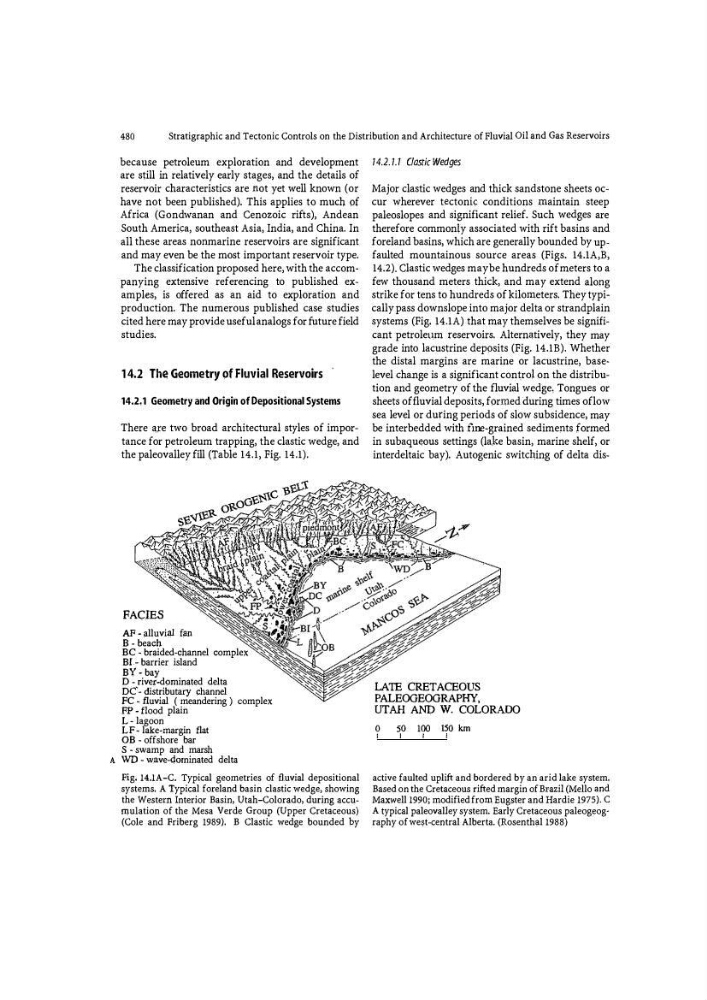
There a;re two broad architectural styles of importance for petroleum trapping, the clastic wedge, and
the paleovalley fill (Table 14.1, Fig. 14.1).
FACIES
AF - alluvi� f;:m
B-beach
BC - braided-channel complex
BL- barrier island
BY - bay
D - river-dominated delta
DC'- distributary channel
FC - fluvial ( meandering ) complex
FP - flood plain
L - lagoon
LF- lake� margin flat
OB -o ffshore bar
S - swamp and marsh
A WD-wave-qmninated delta
Fig. 14.1A-C. Typical geometries of fluvial depositional
systems. A Typical foreland basin clastic wedge, showing
the Western Interior Basin, Utah-Colorado, during accu�
mutation of the Mesa Verde Group (Upper Cretaceous)
(Cole and Friberg 1989). B Clastic wedge bounded Py
14.2.1.1 Clastic Wedges
Major clastic wedges and thick sandstone sheets occur wherever tectoni\: conditions maintain steep
paleoslopes and significant relief. Such wedges are
therefore commonly associated with rift basins and
foreland basins, which are generally bounded by up
faulted mountainous source areas (Figs. 14.1A,B,
14.2). Clastic wedges maybe hundreds of meters to a
few thousand meters thick, and may extend along
strike for tens to hundreds of kilometers. They typically pass downslope into major delta or strandplain
systems (Fig. 14.1A) that may themselves be significant petroleu,m reservoirs. Alternqtively, they may
grade into lacustrine deposits (Fig. 14.1B). Whether
the distal margins are marine or lacustrine, baselevel change is a significant con�rol on the distribution and geometry of the fluvial wedge, Tongues or
sheets of fluvial deposits, formed during times oflow
sea level or during periods of slow subsidence, may
be interbedded with fme -grained sediments formed
in subaqueous settings (lal
PA LEOGEOGRAPHY,
UTAH AND W. COLORADO
0
SO 100 ISO km
active faulted uplift and bordered by an arid lake system.
Based on the Cretaceous rifted margin of Brazil (Mello and
Maxwell 1990; modified from Eug,ster and Hardie 1975). C
A typical paleovalley system. Early Cretaceous paleogeography of we$t-central Alberta. (Rosenth<,ll 1988)
Stratigraphic and Tectonic Controls on the Distribution and Architecture of Fluvial Oil and Gas Reservoirs
because petroleum exploration and development
are still in relatively early stages, and the details of
reservoir characteristics are not yet well known (or
have not been published). This applies to much of
Africa (Gondwanan and Cenozoic rifts), Andean
South America, southeast Asia, India, and China. In
all these areas nonmarine reservoirs are significant
and may even be the most important reservoir type.
The classification proposed here, with the accom�
panying extensive referencing to published examples, is offe red as an aid to exploration and
production. The numerous published case studies
cited here may provide useful analogs for fu ture field
studies.
14.2 Th� G�ometry of Fluvial Reservoirs
14.2,1 Geometry and Origin of Depositional Systems
There a;re two broad architectural styles of importance for petroleum trapping, the clastic wedge, and
the paleovalley fill (Table 14.1, Fig. 14.1).
FACIES
AF - alluvi� f;:m
B-beach
BC - braided-channel complex
BL- barrier island
BY - bay
D - river-dominated delta
DC'- distributary channel
FC - fluvial ( meandering ) complex
FP - flood plain
L - lagoon
LF- lake� margin flat
OB -o ffshore bar
S - swamp and marsh
A WD-wave-qmninated delta
Fig. 14.1A-C. Typical geometries of fluvial depositional
systems. A Typical foreland basin clastic wedge, showing
the Western Interior Basin, Utah-Colorado, during accu�
mutation of the Mesa Verde Group (Upper Cretaceous)
(Cole and Friberg 1989). B Clastic wedge bounded Py
14.2.1.1 Clastic Wedges
Major clastic wedges and thick sandstone sheets occur wherever tectoni\: conditions maintain steep
paleoslopes and significant relief. Such wedges are
therefore commonly associated with rift basins and
foreland basins, which are generally bounded by up
faulted mountainous source areas (Figs. 14.1A,B,
14.2). Clastic wedges maybe hundreds of meters to a
few thousand meters thick, and may extend along
strike for tens to hundreds of kilometers. They typically pass downslope into major delta or strandplain
systems (Fig. 14.1A) that may themselves be significant petroleu,m reservoirs. Alternqtively, they may
grade into lacustrine deposits (Fig. 14.1B). Whether
the distal margins are marine or lacustrine, baselevel change is a significant con�rol on the distribution and geometry of the fluvial wedge, Tongues or
sheets of fluvial deposits, formed during times oflow
sea level or during periods of slow subsidence, may
be interbedded with fme -grained sediments formed
in subaqueous settings (lal
PA LEOGEOGRAPHY,
UTAH AND W. COLORADO
0
SO 100 ISO km
active faulted uplift and bordered by an arid lake system.
Based on the Cretaceous rifted margin of Brazil (Mello and
Maxwell 1990; modified from Eug,ster and Hardie 1975). C
A typical paleovalley system. Early Cretaceous paleogeography of we$t-central Alberta. (Rosenth<,ll 1988)