

414
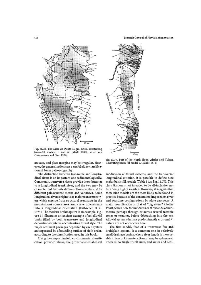
Fig. 11.78. The Salar de Punta Negra, Chile, illustrating
basin-fill models 1 and 6. (Miall 1981b, after van
Overmeeren and Staal 1976)
arcuate1 and plate margins may be irregular. However, the generalizations are a useful aid to classification of basin paleogeography.
The distinction between transverse and longitudinal rivers is an important one sedimentologically.
Commonly, transverse rivers provide the tributaries
to a longitudinal trunk _river, -and the two may be
characterized by quite different fluvial styles and by
different paleocurrent means and variances. Some
longitudinal rivers originate as major transverse rivers which emerge from structural reentrants in the
mountainous source area and curve downstream
into a longitudinal orientation (Eisbacher et al.
1974). The modern Brahmaputra is an example. Figure 9.1 illustrates an ancient example of an alluvial
basin filled by both transverse and longitudinal
depositional systems of contrasting fluvial style. The
major sediment packages deposited by each system
are separated by a bounding surface of sixth order,
according to the classification used in this book.
Using the simple ninefold environmental classification provided above, the proximal-medial-distal
Tectonic Control of Fluvial Sedimentation
'--- -'
!Okm
Fig. 11.79. Part of the North Slope, Alaska and Yukon,
illustrating basin-fill model 2. (Miall l981b)
subdivision of fluvial systems, and the transverse/
longitudinal criterion, it is possible to define nine
major basin-fill models (Table 11.4; Fig. 11.77). This
classification is not intended to be all-inclusive, nature being highly variable. However, it suggests that
these nine models are the most likely to be found in
practice because of the constraints imposed on river
and coastline configurations by plate geometry. A
major cpmplication is that of «big rivers" (Potter
197 8), which flow for hundreds or thousands of kilometers, perhaps through or across several tectonic
zones or terranes, before debouching into the sea.
Alluvial systems that are predominantly erosional in
nature are not of concern here.
The first model, that of a transverse fan and
braidplain system, is a common one in relatively
small drainage basins, where river length is measur�
able in tens of kilometers. Runoff may be ephemeral.
There is no single trunk river, and water and sedi�
Fig. 11.78. The Salar de Punta Negra, Chile, illustrating
basin-fill models 1 and 6. (Miall 1981b, after van
Overmeeren and Staal 1976)
arcuate1 and plate margins may be irregular. However, the generalizations are a useful aid to classification of basin paleogeography.
The distinction between transverse and longitudinal rivers is an important one sedimentologically.
Commonly, transverse rivers provide the tributaries
to a longitudinal trunk _river, -and the two may be
characterized by quite different fluvial styles and by
different paleocurrent means and variances. Some
longitudinal rivers originate as major transverse rivers which emerge from structural reentrants in the
mountainous source area and curve downstream
into a longitudinal orientation (Eisbacher et al.
1974). The modern Brahmaputra is an example. Figure 9.1 illustrates an ancient example of an alluvial
basin filled by both transverse and longitudinal
depositional systems of contrasting fluvial style. The
major sediment packages deposited by each system
are separated by a bounding surface of sixth order,
according to the classification used in this book.
Using the simple ninefold environmental classification provided above, the proximal-medial-distal
Tectonic Control of Fluvial Sedimentation
'--- -'
!Okm
Fig. 11.79. Part of the North Slope, Alaska and Yukon,
illustrating basin-fill model 2. (Miall l981b)
subdivision of fluvial systems, and the transverse/
longitudinal criterion, it is possible to define nine
major basin-fill models (Table 11.4; Fig. 11.77). This
classification is not intended to be all-inclusive, nature being highly variable. However, it suggests that
these nine models are the most likely to be found in
practice because of the constraints imposed on river
and coastline configurations by plate geometry. A
major cpmplication is that of «big rivers" (Potter
197 8), which flow for hundreds or thousands of kilometers, perhaps through or across several tectonic
zones or terranes, before debouching into the sea.
Alluvial systems that are predominantly erosional in
nature are not of concern here.
The first model, that of a transverse fan and
braidplain system, is a common one in relatively
small drainage basins, where river length is measur�
able in tens of kilometers. Runoff may be ephemeral.
There is no single trunk river, and water and sedi�