

Basic Paleogeographic Models for Nonmarine Basins
high-sinuosit y flu vi al, 5. river-dominated delta, 6.
wave-dominated delta, 7. tide-dominated delta, 8.
nond eltaic coast (beach and barrier systems) , and 9.
estu arine.
For the purpose of this analysis, a twofold subdivision of fluvi al environments into rivers of high and
low si nu osity is adequate. This serves, in most cases,
Table 11.4. Alluvial basin-f ill patternsa
Model Proximal
Medial
T fan
T braid
plain
2
T fan-delta
3
T fan/river
T river4
T fan/river
T river
5
T fan/river
T river
6
T fan/river
L river
7
T fan/river
L river
8
T fan/river
L river
9
T fan/river
L river
T, Transverse; L, longitudinal.
'From Miall (198lb).
Distal
Lake margin/nondeltaic coast
Lake margin/sea coast
River-dominated delta
River-dominated delta
with barrier lagoon
Wave-dominated delta
Lake margin/ estuary
River-dominated delta
Tide-dominated delta
Wave-dominated delta
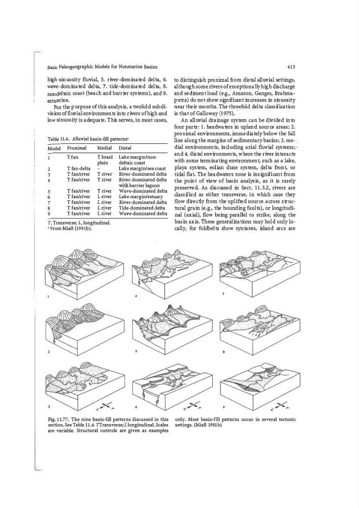
Fig. ll.77. The nine basin-fill patterns discussed in this
section. See Table 11.4. TTransverse; L longitudinal. Scales
are variable. Structural controls are given as examples
413
to distinguish proxi mal f i -om distal alluvial settings,
although some ri vers of exc eptionally high disch arge
and sediment load (e.g., Amazon, Ganges, Brahmaput ra) do not sh ow significant increases in sinuosit y
near their mouths. Th e threefold delta classification
is that of Galloway (1975). ·
An alluvial drainage system can be divided into
four parts: 1. headwaters in upland source areas; 2.
proximal environments, immediately below the fall
li ne along the margins of sedimentary basins; 3. me- .
dial environments, includi ng axi al fluvial systems; ,
and 4. distal environments, where the river interacts
with some terminating environment, such as a lake,
playa system, eolian dune system, q.elta front, or
tidal flat. Th e headwaters zone is insignificant from
the point of vi ew of basi n analysis? as it is rarely
preserved. As discussed in Sect . 11.3.2, ri vers are
classified as either transverse, in which case they
flow directly from the uplifted source across structural grain (e.g., the bounding faults), or longitudinal (axial), flow being parallel to st ri ke, along the
basin axis. Th ese generalizations may hold only locally, for foldbelts sh ow syntaxes, island arc s are
only. Most basin�flll patterns occur in several tectonic
settings. (Miall 1981 b)
high-sinuosit y flu vi al, 5. river-dominated delta, 6.
wave-dominated delta, 7. tide-dominated delta, 8.
nond eltaic coast (beach and barrier systems) , and 9.
estu arine.
For the purpose of this analysis, a twofold subdivision of fluvi al environments into rivers of high and
low si nu osity is adequate. This serves, in most cases,
Table 11.4. Alluvial basin-f ill patternsa
Model Proximal
Medial
T fan
T braid
plain
2
T fan-delta
3
T fan/river
T river4
T fan/river
T river
5
T fan/river
T river
6
T fan/river
L river
7
T fan/river
L river
8
T fan/river
L river
9
T fan/river
L river
T, Transverse; L, longitudinal.
'From Miall (198lb).
Distal
Lake margin/nondeltaic coast
Lake margin/sea coast
River-dominated delta
River-dominated delta
with barrier lagoon
Wave-dominated delta
Lake margin/ estuary
River-dominated delta
Tide-dominated delta
Wave-dominated delta
Fig. ll.77. The nine basin-fill patterns discussed in this
section. See Table 11.4. TTransverse; L longitudinal. Scales
are variable. Structural controls are given as examples
413
to distinguish proxi mal f i -om distal alluvial settings,
although some ri vers of exc eptionally high disch arge
and sediment load (e.g., Amazon, Ganges, Brahmaput ra) do not sh ow significant increases in sinuosit y
near their mouths. Th e threefold delta classification
is that of Galloway (1975). ·
An alluvial drainage system can be divided into
four parts: 1. headwaters in upland source areas; 2.
proximal environments, immediately below the fall
li ne along the margins of sedimentary basins; 3. me- .
dial environments, includi ng axi al fluvial systems; ,
and 4. distal environments, where the river interacts
with some terminating environment, such as a lake,
playa system, eolian dune system, q.elta front, or
tidal flat. Th e headwaters zone is insignificant from
the point of vi ew of basi n analysis? as it is rarely
preserved. As discussed in Sect . 11.3.2, ri vers are
classified as either transverse, in which case they
flow directly from the uplifted source across structural grain (e.g., the bounding faults), or longitudinal (axial), flow being parallel to st ri ke, along the
basin axis. Th ese generalizations may hold only locally, for foldbelts sh ow syntaxes, island arc s are
only. Most basin�flll patterns occur in several tectonic
settings. (Miall 1981 b)