

Basic Paleogeographic Models for Nonmarine Basins
ment discharge at base level is inadequate to develop
maj or deltas. Rivers may terminate as a networ k of
shallow distributaries or as a zone of sheetflooding
on a lake mar gin, playa, or tidal flat. Inter montane
lake basins (basin ty pe 4.3 in Table 11.2) are commonly bordered by this type of alluvial pattern (e.g.,
parts of the Salar de Punta Negra, Chile: Fig. 11.78).
The pattern is als o common in rift basins (basin type
1.1)1 such as Death Valley, Califor nia, and the East
African Rift System. Some of the Tr iassic rift basins
of eas tern North America als o fit this pattern
(Hubert et a\ . 1976; P.E. Olsen 1990), as does the
Tertiary of Uinta Bas in, Utah (basin type 2.4).
Ballance (1 98 0) described an ex ample in a moder n
wrench-fault basin. Miall and Gibling (1 978 ) described a Devonian ex ample of such a pattern fl anking the fault-bounded Boothia Uplift in Arctic
Canada. Alluvial fans along the flanks of the mountains drained into a sandy braidplain and an arid
tidal fl at.
Model 2 is a variant of the first model, in which the
alluvial fans drain directly into a standing body of
water as fan deltas or braid-deltas (Fig. 11.79).
McPhers on et a\ . (1987) and Nemec and Steel (1 988 )
provided discussions and classifications of these
types of depositional system. Fan deltas ty pically are
small, gr avel-dominated systems, a few kilometers
across. This patter n occurs on coas tlines flanking
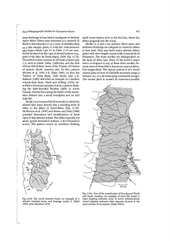
Fig. 11.80. The north_ Sumatra basin, an example of a
retroarc foreland basin, and drainage model 3. (Miall
198lb, after Hamilton 1979)
415
small ocean basins, such as the Red Sea, where fan
deltas pr ograde into the ocean.
Models 3, 4, and 5 are systems where water and
sediment discharge are adequate to construct deltas
at base level. They may build major alluvial-deltaic
plains with river length� measurable in hundreds of
kil ometers . The three models ar e distinguished on
the basis of delta type. None of the world's major
rivers correspond to any of these three models , because mos t of these follow structures, and are therefore longitudinal. The typical pattern is of a broad
coas tal plain in front of a foldb elt mountain range, a
volcanic ar c, or a down warping continental margin.
The coas tal plain is cr os sed by numerous parallel,
Fig. 11.81. Part of the coastal plain of Georgia and North
and South Carolina. An example of basin-fill model 4.
Open stippling indicates areas of active sedimentation;
closed stippling indicates older deposits fo rmed in the
same tectonic environment. (Miall 198lb)
ment discharge at base level is inadequate to develop
maj or deltas. Rivers may terminate as a networ k of
shallow distributaries or as a zone of sheetflooding
on a lake mar gin, playa, or tidal flat. Inter montane
lake basins (basin ty pe 4.3 in Table 11.2) are commonly bordered by this type of alluvial pattern (e.g.,
parts of the Salar de Punta Negra, Chile: Fig. 11.78).
The pattern is als o common in rift basins (basin type
1.1)1 such as Death Valley, Califor nia, and the East
African Rift System. Some of the Tr iassic rift basins
of eas tern North America als o fit this pattern
(Hubert et a\ . 1976; P.E. Olsen 1990), as does the
Tertiary of Uinta Bas in, Utah (basin type 2.4).
Ballance (1 98 0) described an ex ample in a moder n
wrench-fault basin. Miall and Gibling (1 978 ) described a Devonian ex ample of such a pattern fl anking the fault-bounded Boothia Uplift in Arctic
Canada. Alluvial fans along the flanks of the mountains drained into a sandy braidplain and an arid
tidal fl at.
Model 2 is a variant of the first model, in which the
alluvial fans drain directly into a standing body of
water as fan deltas or braid-deltas (Fig. 11.79).
McPhers on et a\ . (1987) and Nemec and Steel (1 988 )
provided discussions and classifications of these
types of depositional system. Fan deltas ty pically are
small, gr avel-dominated systems, a few kilometers
across. This patter n occurs on coas tlines flanking
Fig. 11.80. The north_ Sumatra basin, an example of a
retroarc foreland basin, and drainage model 3. (Miall
198lb, after Hamilton 1979)
415
small ocean basins, such as the Red Sea, where fan
deltas pr ograde into the ocean.
Models 3, 4, and 5 are systems where water and
sediment discharge are adequate to construct deltas
at base level. They may build major alluvial-deltaic
plains with river length� measurable in hundreds of
kil ometers . The three models ar e distinguished on
the basis of delta type. None of the world's major
rivers correspond to any of these three models , because mos t of these follow structures, and are therefore longitudinal. The typical pattern is of a broad
coas tal plain in front of a foldb elt mountain range, a
volcanic ar c, or a down warping continental margin.
The coas tal plain is cr os sed by numerous parallel,
Fig. 11.81. Part of the coastal plain of Georgia and North
and South Carolina. An example of basin-fill model 4.
Open stippling indicates areas of active sedimentation;
closed stippling indicates older deposits fo rmed in the
same tectonic environment. (Miall 198lb)