

Plate-Tectonic Setting of Alluvial Basins
�
"
�
.. �
, A �
"
·�
•
�
PQ
=
�
"'
� :ii
=
I !;
<:
w
;;� �
:. ��
:; � � �
8� � it (i.i
f �
•
8
385
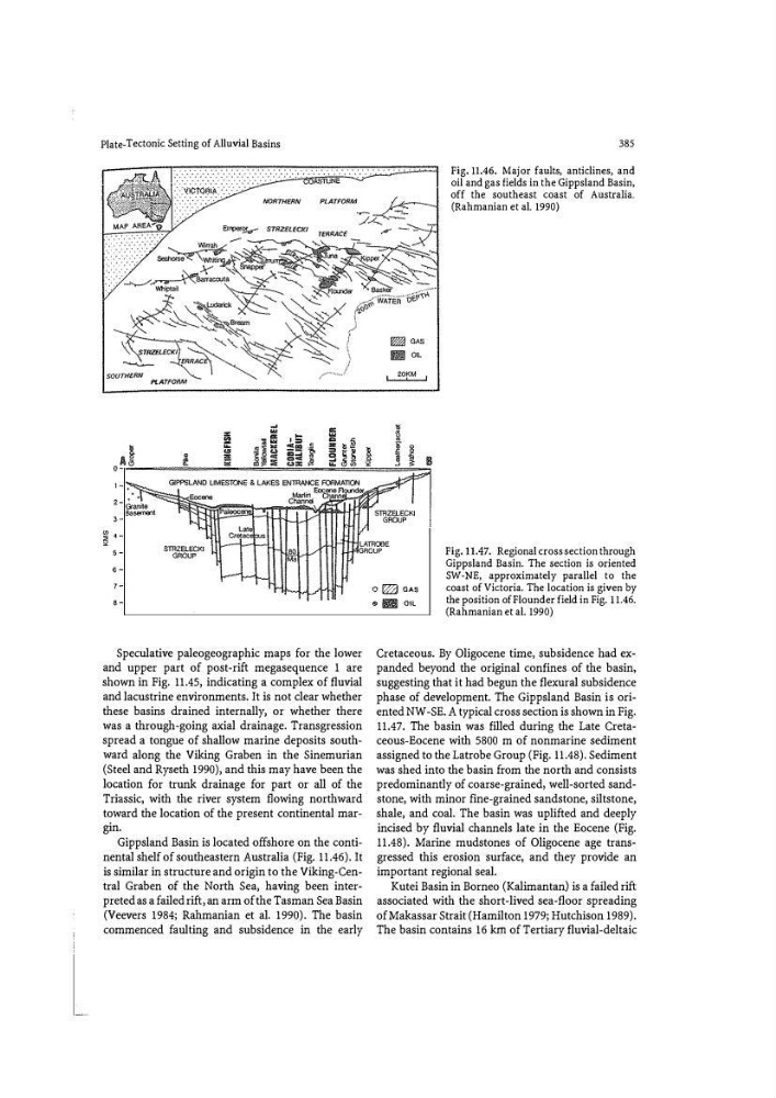
Fig. 11.46. Major faults, anticlines, and
oil and gas fields in the Gippsland Basin,
off the southeast coast of Australia.
(Rahmanian et al. 1990)
80
LLJ HTt1lATROOE
GROUP
Fig. 11.47. Regional cross section through
Gippsland Basin. The section is oriented
SW -NE, approximately parallel to the
coast of Victoria. The location is given by
the position of Flounder field in Fig. 11.46.
(Rahmanian et al. 1990)
8
Speculative paleogeographic maps for the lower
and upper part of post-rift megasequence 1 are
shown in Fig. 11.45, indicating a complex of fluvial
and lacustrine environments. It is not clear whether
these basins drained internally, or whether there
was a through-going axial drainage. Transgression
spread a tongue of shallow marine deposits southward along the Viking Graben in the Sinemurian
(Steel and Ryseth 1990), and this may have been the
location for trunk drainage for part or all of the
Triassic, with the river system fl owing northward
toward the location of the present continental margin.
Gippsland Basin is located offshore on the continental shelf of southeastern Australia (Fig. 11.46). It
is similar in structure and origin to the Viking-Central Graben of the North Sea, having been interpreted as a failed rift, an arm of the Tasman Sea Basin
(Veevers 1984; Rahmanian et a!. 1990). The basin
commenced faulting and subsidence in the early
0 IT2j GAS
61 !ill OIL
Cretaceous. By Oligocene time, subsidence had expanded beyond the original confines of the basin,
suggesting that it had begun the flexural subsidence
phase of development. The Gippsland Basin is oriented NW -SE. A typical cross section is shown in Fig.
11.47. The basin was filled during the Late Cretaceous-Eocene with 5800 m of nonmarine sediment
assigned to the Latrobe Group (Fig. 11.48). Sediment
was shed into the basin from the north and consists
predominantly of coarse-grained) well-sorted sandstone, with minor fine-grained sandstone, siltstone,
shale, and coal. The basin was uplifted and deeply
incised by fluvial channels late in the Eocene (Fig.
11.48). Marine mudstones of Oligocene age transgressed this erosion surface, and they provide an
important regional seal.
Kutei Basin in Borneo (Kalimantan) is a failed rift
associated with the short-lived sea-floor spreading
ofMakassar Strait (Hamilton 1979; Hutchison 1989).
The basin contains 16 km of Tertiary fluvial-deltaic
�
"
�
.. �
, A �
"
·�
•
�
PQ
=
�
"'
� :ii
=
I !;
<:
w
;;� �
:. ��
:; � � �
8� � it (i.i
f �
•
8
385
Fig. 11.46. Major faults, anticlines, and
oil and gas fields in the Gippsland Basin,
off the southeast coast of Australia.
(Rahmanian et al. 1990)
80
LLJ HTt1lATROOE
GROUP
Fig. 11.47. Regional cross section through
Gippsland Basin. The section is oriented
SW -NE, approximately parallel to the
coast of Victoria. The location is given by
the position of Flounder field in Fig. 11.46.
(Rahmanian et al. 1990)
8
Speculative paleogeographic maps for the lower
and upper part of post-rift megasequence 1 are
shown in Fig. 11.45, indicating a complex of fluvial
and lacustrine environments. It is not clear whether
these basins drained internally, or whether there
was a through-going axial drainage. Transgression
spread a tongue of shallow marine deposits southward along the Viking Graben in the Sinemurian
(Steel and Ryseth 1990), and this may have been the
location for trunk drainage for part or all of the
Triassic, with the river system fl owing northward
toward the location of the present continental margin.
Gippsland Basin is located offshore on the continental shelf of southeastern Australia (Fig. 11.46). It
is similar in structure and origin to the Viking-Central Graben of the North Sea, having been interpreted as a failed rift, an arm of the Tasman Sea Basin
(Veevers 1984; Rahmanian et a!. 1990). The basin
commenced faulting and subsidence in the early
0 IT2j GAS
61 !ill OIL
Cretaceous. By Oligocene time, subsidence had expanded beyond the original confines of the basin,
suggesting that it had begun the flexural subsidence
phase of development. The Gippsland Basin is oriented NW -SE. A typical cross section is shown in Fig.
11.47. The basin was filled during the Late Cretaceous-Eocene with 5800 m of nonmarine sediment
assigned to the Latrobe Group (Fig. 11.48). Sediment
was shed into the basin from the north and consists
predominantly of coarse-grained) well-sorted sandstone, with minor fine-grained sandstone, siltstone,
shale, and coal. The basin was uplifted and deeply
incised by fluvial channels late in the Eocene (Fig.
11.48). Marine mudstones of Oligocene age transgressed this erosion surface, and they provide an
important regional seal.
Kutei Basin in Borneo (Kalimantan) is a failed rift
associated with the short-lived sea-floor spreading
ofMakassar Strait (Hamilton 1979; Hutchison 1989).
The basin contains 16 km of Tertiary fluvial-deltaic