

356
Tectonic Control of Fluvial Sedimentation
!150m
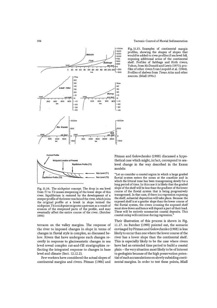
Fig. 11.15. Examples of continental margin
1500
profiles, showing the shapes of slopes that
1250
!000
would be added to river profiles if sea level fell,
750
exposing additional areas of the continental
500
shelf. Profiles of Babbage and Firth rivers,
"'
�Q0$1
0
Yukon, from McDonald and Lewis (1973); pro0
" 40" 60 80 tOO 120 140 160 ISO 2.00 220 -250
files of other rivers from Leopold et aL {1964).
•m
-500
Profiles of shelves from Times Atlas and other
'dm
sources. (Miall l991c)
GO
50
50m
"
<0
Lower Indus 30
30
20
Murray
"
"
"
0000
s�o Mel 0
�nost
j/f(/ mvol
0
200
•oo
500
500
_,
,00
<00
'"
600 _,
•m
-20
•m
- 50
- <0
IOOOm
Rio Grande 500
Nile
coast
scr;; lever
0
sea /
1500
500
'"'
2500
•m
-300
•m
Fig. 11.16. The nickpoint concept. The drop in sea level
from Tl to T2 causes steepening of the lower slope of this
river. Equilibrium is restored by the development of a
steeper profJJ .e of the lower reaches of the river, which joins
the original profile at a break in slope termed the
nickpoint. This nickpoint migrates upstream as a result of
erosion of the steepened parts of the profile· , and may
eventually affect the entire course of the river. (Butcher
1990)
terraces on the valley margins. The response of
the river to imposed changes in slope in terms of
changes in fluvial style is complex, as discussed below. Rivers that have undergone such changes recently in response to gladoeustatic changes in sea
level reveal complex cut-and-fill stratigraphies reflecting the integrated response to changes in base
level and climate (Sect. 12.12.2).
Few workers have considered the actual slopes of
continental margins and rivers. Pitman (1986) and
-20
-50
_.,,
IOOOm
500
0
-300
Pitman and Golovchenko (1988) discussed a hypothetical case which might, in fact, correspond to sealevel change in the way described in the Exxon
models:
�'Let us consider a coastal region in which a large graded
fluvial system enters the ocean at the coastline and in
which the littoral zone has been transgressing slowly for a
long period of time. In this case it is likely that the graded
slope of the shelf will be less than the gradient of the lower
course of the fl uvial system that is being progressively
transgressed. In that case, if there is a regression exposing
the shelf, subaerial deposition will take place. Because the
exposed shelf is at a gentler slope than the lower course of
the fl uvial system, the rivers crossing the exposed shelf
must slow down and hence will deposit a part of their load.
These will be entirely nonmarine coastal deposits. This
coastal onlap will continue during regression.''
Their illustration of this process is shown in Fig.
11.17. As Butcher (1990) pointed out, the scenario
envisaged by Pitman and Golovchenko (1988) is less
likely to occur than one where the lower course of the
river has a lower slope than the continental shelf.
This is especially likely to be the case where rivers
have had an extended time period to build a coastal
plain - the very situation most likely to be of interest
to geologists because of the high preservation potential of such accumulations on slowly subsiding continental margins. In order to test these points, Miall
Tectonic Control of Fluvial Sedimentation
!150m
Fig. 11.15. Examples of continental margin
1500
profiles, showing the shapes of slopes that
1250
!000
would be added to river profiles if sea level fell,
750
exposing additional areas of the continental
500
shelf. Profiles of Babbage and Firth rivers,
"'
�Q0$1
0
Yukon, from McDonald and Lewis (1973); pro0
" 40" 60 80 tOO 120 140 160 ISO 2.00 220 -250
files of other rivers from Leopold et aL {1964).
•m
-500
Profiles of shelves from Times Atlas and other
'dm
sources. (Miall l991c)
GO
50
50m
"
<0
Lower Indus 30
30
20
Murray
"
"
"
0000
s�o Mel 0
�nost
j/f(/ mvol
0
200
•oo
500
500
_,
,00
<00
'"
600 _,
•m
-20
•m
- 50
- <0
IOOOm
Rio Grande 500
Nile
coast
scr;; lever
0
sea /
1500
500
'"'
2500
•m
-300
•m
Fig. 11.16. The nickpoint concept. The drop in sea level
from Tl to T2 causes steepening of the lower slope of this
river. Equilibrium is restored by the development of a
steeper profJJ .e of the lower reaches of the river, which joins
the original profile at a break in slope termed the
nickpoint. This nickpoint migrates upstream as a result of
erosion of the steepened parts of the profile· , and may
eventually affect the entire course of the river. (Butcher
1990)
terraces on the valley margins. The response of
the river to imposed changes in slope in terms of
changes in fluvial style is complex, as discussed below. Rivers that have undergone such changes recently in response to gladoeustatic changes in sea
level reveal complex cut-and-fill stratigraphies reflecting the integrated response to changes in base
level and climate (Sect. 12.12.2).
Few workers have considered the actual slopes of
continental margins and rivers. Pitman (1986) and
-20
-50
_.,,
IOOOm
500
0
-300
Pitman and Golovchenko (1988) discussed a hypothetical case which might, in fact, correspond to sealevel change in the way described in the Exxon
models:
�'Let us consider a coastal region in which a large graded
fluvial system enters the ocean at the coastline and in
which the littoral zone has been transgressing slowly for a
long period of time. In this case it is likely that the graded
slope of the shelf will be less than the gradient of the lower
course of the fl uvial system that is being progressively
transgressed. In that case, if there is a regression exposing
the shelf, subaerial deposition will take place. Because the
exposed shelf is at a gentler slope than the lower course of
the fl uvial system, the rivers crossing the exposed shelf
must slow down and hence will deposit a part of their load.
These will be entirely nonmarine coastal deposits. This
coastal onlap will continue during regression.''
Their illustration of this process is shown in Fig.
11.17. As Butcher (1990) pointed out, the scenario
envisaged by Pitman and Golovchenko (1988) is less
likely to occur than one where the lower course of the
river has a lower slope than the continental shelf.
This is especially likely to be the case where rivers
have had an extended time period to build a coastal
plain - the very situation most likely to be of interest
to geologists because of the high preservation potential of such accumulations on slowly subsiding continental margins. In order to test these points, Miall