

L.
Tectonic Control of Alluvial Stratigraphy
•
Ci&] COASTAL SEDIMENTS
� MARINE SEDIMENTS
lEVEL
LEVEL
LEVEL
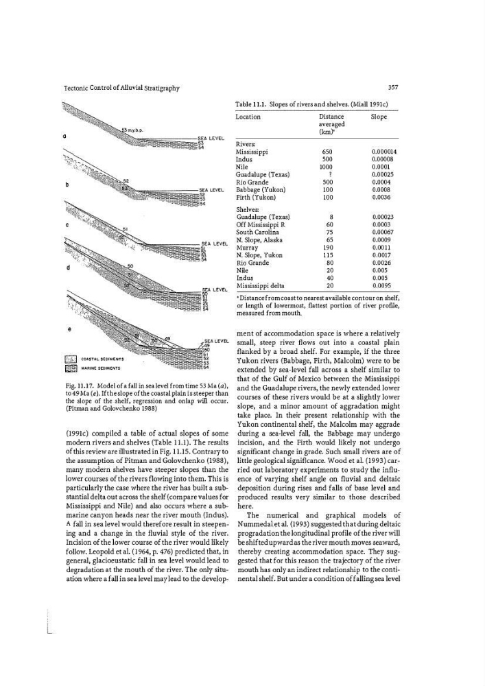
Fig. 11.17. Model of a fall in sea level from time 53 Ma (a),
to 49 Ma (e). If the slope of the coastal plain is steeper than
the slope of the shelf, regression and onlap will occur.
(Pitman and Golovchenko 1988)
(1991c) compiled a table of actual slopes of some
modern rivers and shelves (Table 1 1.1). The results
of this review are illustrated in Fig. 1 1.15. Contrary to
the assumption of Pitman and Golovchenko (1988),
many modern shelves have steeper slopes than the
lower courses of the rivers flowing into them. This is
particularly the case where the river has built a substantial delta out across the shelf (compare values for
Mississippi and Nile) and also occurs where a submarine canyon heads near the river mouth (Indus).
A fall in sea level would therefore result in steepening and a change in the fluvial style of the river.
Incision of the lower course of the river would likely
follow. Leopold et a!. (1964, p. 476) predicted that, in
general, glacioeustatic fall in sea level would lead to
degradation at the mouth of the river. The only situation where a fall in sea level may lead to the develop357
Table 11.1. Slopes of rivers and shelves, (Miall l991c)
Location
Rivers:
Mississippi
Indus
Nile
Guadalupe (Texas)
Rio Grande
Babbage (Yukon)
Firth (Yukon)
Shelves:
Guadalupe (Texas)
Off Mississippi R
South Carolina
N. Slope, Alaska
Murray
N. Slope, Yukon
Rio Grande
Nile
Indus
Mississippi delta
Distance
averaged
(km)'
650
500
1000
500
100
100
8
60
75
65
190
115
80
20
40
20
Slope
0.000014
0.00008
0.0001
0.00025
0.0004
0.0008
0.0036
0.00023
0.0003
0.00067
0.0009
0.0011
0.0017
0.0026
0.005
0.005
0.0095
• Distance from coast to nearest available contour on shelf,
or length of lowermost, flattest portion of river profll e,
measured from mouth .
ment of accommodation space is where a relatively
small, steep river flows out into a coastal plain
fl anked by a broad shelf. For example, if the three
Yukon rivers (Babbage, Firth, Malcolm) were to be
extended by sea-level fall across a shelf similar to
that of the Gulf of Mexico between the Mississippi
and the Guadalupe rivers, the newly extended lower
courses of these rivers would be at a slightly lower
slope, and a minor amount of aggradation might
take place. In their present relationship with the
Yukon continental shelf, the Malcolm may aggrade
during a sea-level fall, the Babbage may undergo
incision, and the Firth would likely not undergo
significant change in grade. Such small rivers are of
little geological significance. Wood et a!. (1993) carried out laboratory experiments to study the influence of varying shelf angle on fluvial and deltaic
deposition during rises and falls of base level and
produced results very similar to those described
here.
The numerical and graphical models of
Nummedal et a]. (1993) suggested that during deltaic
progradation the longitudinal proflle of the river will
be shifted upward as the river mouth moves seaward,
thereby creating accommodation space. They suggested that for this reason the trajectory of the river
mouth has only an indirect relationship to the continental shelf. But under a condition of falling sea level
Tectonic Control of Alluvial Stratigraphy
•
Ci&] COASTAL SEDIMENTS
� MARINE SEDIMENTS
lEVEL
LEVEL
LEVEL
Fig. 11.17. Model of a fall in sea level from time 53 Ma (a),
to 49 Ma (e). If the slope of the coastal plain is steeper than
the slope of the shelf, regression and onlap will occur.
(Pitman and Golovchenko 1988)
(1991c) compiled a table of actual slopes of some
modern rivers and shelves (Table 1 1.1). The results
of this review are illustrated in Fig. 1 1.15. Contrary to
the assumption of Pitman and Golovchenko (1988),
many modern shelves have steeper slopes than the
lower courses of the rivers flowing into them. This is
particularly the case where the river has built a substantial delta out across the shelf (compare values for
Mississippi and Nile) and also occurs where a submarine canyon heads near the river mouth (Indus).
A fall in sea level would therefore result in steepening and a change in the fluvial style of the river.
Incision of the lower course of the river would likely
follow. Leopold et a!. (1964, p. 476) predicted that, in
general, glacioeustatic fall in sea level would lead to
degradation at the mouth of the river. The only situation where a fall in sea level may lead to the develop357
Table 11.1. Slopes of rivers and shelves, (Miall l991c)
Location
Rivers:
Mississippi
Indus
Nile
Guadalupe (Texas)
Rio Grande
Babbage (Yukon)
Firth (Yukon)
Shelves:
Guadalupe (Texas)
Off Mississippi R
South Carolina
N. Slope, Alaska
Murray
N. Slope, Yukon
Rio Grande
Nile
Indus
Mississippi delta
Distance
averaged
(km)'
650
500
1000
500
100
100
8
60
75
65
190
115
80
20
40
20
Slope
0.000014
0.00008
0.0001
0.00025
0.0004
0.0008
0.0036
0.00023
0.0003
0.00067
0.0009
0.0011
0.0017
0.0026
0.005
0.005
0.0095
• Distance from coast to nearest available contour on shelf,
or length of lowermost, flattest portion of river profll e,
measured from mouth .
ment of accommodation space is where a relatively
small, steep river flows out into a coastal plain
fl anked by a broad shelf. For example, if the three
Yukon rivers (Babbage, Firth, Malcolm) were to be
extended by sea-level fall across a shelf similar to
that of the Gulf of Mexico between the Mississippi
and the Guadalupe rivers, the newly extended lower
courses of these rivers would be at a slightly lower
slope, and a minor amount of aggradation might
take place. In their present relationship with the
Yukon continental shelf, the Malcolm may aggrade
during a sea-level fall, the Babbage may undergo
incision, and the Firth would likely not undergo
significant change in grade. Such small rivers are of
little geological significance. Wood et a!. (1993) carried out laboratory experiments to study the influence of varying shelf angle on fluvial and deltaic
deposition during rises and falls of base level and
produced results very similar to those described
here.
The numerical and graphical models of
Nummedal et a]. (1993) suggested that during deltaic
progradation the longitudinal proflle of the river will
be shifted upward as the river mouth moves seaward,
thereby creating accommodation space. They suggested that for this reason the trajectory of the river
mouth has only an indirect relationship to the continental shelf. But under a condition of falling sea level