

348
\ . ...... ... .
-·1km
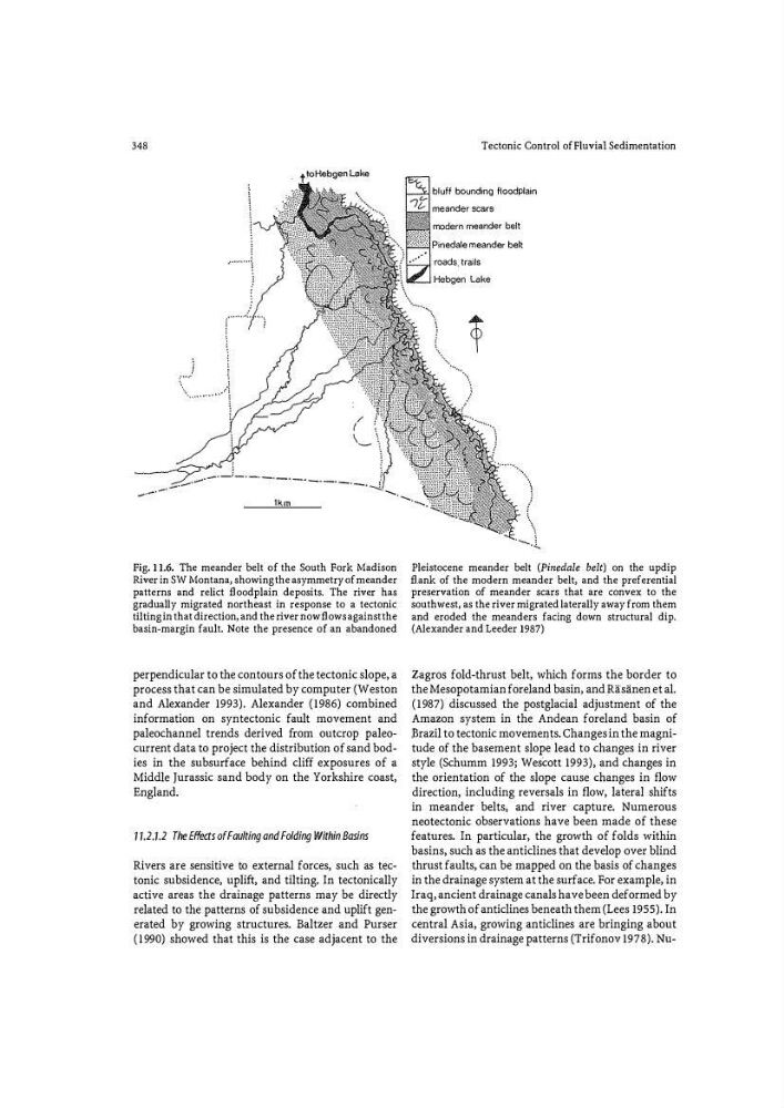
Fig. 11.6. The meander belt of the South Fork Madison
River in SW Montana, showing the asymmetry of meander
patterns and relict fl oodplain deposits. The river has
gradually migrated northeast in response to a tectonic
tilting in that direction, and the river now fl ows against the
basin*margin fault. Note the presence of an abandoned
perpendicular to the contours of the tectonic slope, a
process that can be simulated by computer (Weston
and Alexander 1993). Alexander (1986) combined
information on syntectonic fault movement and
paleochannel trends derived from outcrop paleocurrent data to project the distribution of sand bodies in the subsurface behind cliff exposures of a
Middle Jurassic sand body on the Yorkshire coast,
England.
1 1.2.1.2 The Effects of Faulting and Folding Within Basins
Rivers are sensitive to external forces, such as tectonic subsidence, uplift, and tilting. In tectonically
active areas the drainage patterns may be directly
related to the patterns of subsidence and uplift generated by growing structures. Baltzer and Purser
(1990) showed that this is the case adjacent to the
Tectonic Control of Fluvial Sedimentation
bluff bounding floodplain
Pinedale meander belt
Pleistocene meander belt (Pinedale belt) on the updip
flank of the modern meander belt, and the preferential
preservation of meander scars that are convex to the
southwest, as the river migrated laterally away from them
and eroded the meanders facing down structural dip.
(Alexander and Leeder 1987)
Zagros fold-thrust belt, which forms the border to
the Mesopotamian foreland basin, and Rifsanen et al.
(1987) discussed the postglacial adjustment of the
Amazon system in the Andean foreland basin of
Brazil to tectonic movements. Changes in the magnitude of the basement slope lead to changes in river
style (Schumm 1993; Wescott 1993), and changes in
the orientation of the slope cause changes in flow
direction, including reversals in flow, lateral shifts
in meander belts, and river capture. Numerous
neotectonic observations have been made of these
features. In particular, the growth of folds within
basins, such as the anticlines that develop over blind
thrust faults, can be mapped on the basis of changes
in the drainage system at the surface. For example, in
Iraq, ancient drainage canals have been deformed by
the growth of anticlines beneath them (Lees 1955). In
central Asia, growing anticlines are bringing about
diversions in drainage patterns (Trifonov 1978). Nu-
\ . ...... ... .
-·1km
Fig. 11.6. The meander belt of the South Fork Madison
River in SW Montana, showing the asymmetry of meander
patterns and relict fl oodplain deposits. The river has
gradually migrated northeast in response to a tectonic
tilting in that direction, and the river now fl ows against the
basin*margin fault. Note the presence of an abandoned
perpendicular to the contours of the tectonic slope, a
process that can be simulated by computer (Weston
and Alexander 1993). Alexander (1986) combined
information on syntectonic fault movement and
paleochannel trends derived from outcrop paleocurrent data to project the distribution of sand bodies in the subsurface behind cliff exposures of a
Middle Jurassic sand body on the Yorkshire coast,
England.
1 1.2.1.2 The Effects of Faulting and Folding Within Basins
Rivers are sensitive to external forces, such as tectonic subsidence, uplift, and tilting. In tectonically
active areas the drainage patterns may be directly
related to the patterns of subsidence and uplift generated by growing structures. Baltzer and Purser
(1990) showed that this is the case adjacent to the
Tectonic Control of Fluvial Sedimentation
bluff bounding floodplain
Pinedale meander belt
Pleistocene meander belt (Pinedale belt) on the updip
flank of the modern meander belt, and the preferential
preservation of meander scars that are convex to the
southwest, as the river migrated laterally away from them
and eroded the meanders facing down structural dip.
(Alexander and Leeder 1987)
Zagros fold-thrust belt, which forms the border to
the Mesopotamian foreland basin, and Rifsanen et al.
(1987) discussed the postglacial adjustment of the
Amazon system in the Andean foreland basin of
Brazil to tectonic movements. Changes in the magnitude of the basement slope lead to changes in river
style (Schumm 1993; Wescott 1993), and changes in
the orientation of the slope cause changes in flow
direction, including reversals in flow, lateral shifts
in meander belts, and river capture. Numerous
neotectonic observations have been made of these
features. In particular, the growth of folds within
basins, such as the anticlines that develop over blind
thrust faults, can be mapped on the basis of changes
in the drainage system at the surface. For example, in
Iraq, ancient drainage canals have been deformed by
the growth of anticlines beneath them (Lees 1955). In
central Asia, growing anticlines are bringing about
diversions in drainage patterns (Trifonov 1978). Nu-