

Quantitative Studies of Alluvial Architecture
B.
sm311 �C31e
•�strnt
�r� �3r
larqe scale
x-strat.
329
'·
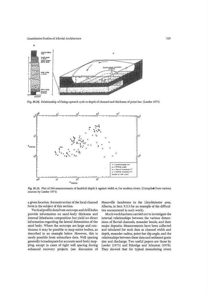
Fig. 10.2Q. Relationship of fining-upward cycle to depth of channel and thickness of point bar. (Leeder 1973)
' o '
0
0
8
0
0
10
1
' o'
h � bankfull depth >1m
w � w�kfull width
o • d'anncl s"""'s•ty> 1 · 1
o" channel sinuo�;ty�l· 7
�ample of 104 rivers
Fig. 10.21. Plot of 104 measurements of bankfull depth h against width w, for modern rivers. (Compile� from various
sources by Leeder 1973)
a given location. Reconstruction of the local channel
form is the subject of this section.
Vertical profile data from outcrops and drill holes
provide information on sand-body thickness and
internal lithofacies composition but yield no direct
information regarding the lateral dimensions of the
sand body. Where the outcrops are large and continuous it may be possible to map entire bodies, as
described in an example below. However, this is
rarely possible from subsurface data. Well spacing
generally is inadequate for accurate sand-body mapping, except in cases of tight well spacing during
enhanced recovery projects (see discussion of
Mannville Sandstone in the Lloydminster area,
Alberta, in Sect. 9.5.3 for an example of the difficulties encountered in such work).
Much work has been carried out to investigate the
internal relationships between the various dimensions of fluvial channels, meander bends, and their
major deposits. Measurements have been collected
and tabulated for such data as channel width and
depth, meander radius, point-bar dip angle, and the
relationships between these data and sediment grain
size and discharge. Two useful papers are those by
Leeder (1973) and Ethridge and Schumm (1978).
They showed that for typical meandering rivers
B.
sm311 �C31e
•�strnt
�r� �3r
larqe scale
x-strat.
329
'·
Fig. 10.2Q. Relationship of fining-upward cycle to depth of channel and thickness of point bar. (Leeder 1973)
' o '
0
0
8
0
0
10
1
' o'
h � bankfull depth >1m
w � w�kfull width
o • d'anncl s"""'s•ty> 1 · 1
o" channel sinuo�;ty�l· 7
�ample of 104 rivers
Fig. 10.21. Plot of 104 measurements of bankfull depth h against width w, for modern rivers. (Compile� from various
sources by Leeder 1973)
a given location. Reconstruction of the local channel
form is the subject of this section.
Vertical profile data from outcrops and drill holes
provide information on sand-body thickness and
internal lithofacies composition but yield no direct
information regarding the lateral dimensions of the
sand body. Where the outcrops are large and continuous it may be possible to map entire bodies, as
described in an example below. However, this is
rarely possible from subsurface data. Well spacing
generally is inadequate for accurate sand-body mapping, except in cases of tight well spacing during
enhanced recovery projects (see discussion of
Mannville Sandstone in the Lloydminster area,
Alberta, in Sect. 9.5.3 for an example of the difficulties encountered in such work).
Much work has been carried out to investigate the
internal relationships between the various dimensions of fluvial channels, meander bends, and their
major deposits. Measurements have been collected
and tabulated for such data as channel width and
depth, meander radius, point-bar dip angle, and the
relationships between these data and sediment grain
size and discharge. Two useful papers are those by
Leeder (1973) and Ethridge and Schumm (1978).
They showed that for typical meandering rivers