

Quantitative Studies of Alluvial Architecture
327
SHEET
SANDSiONE
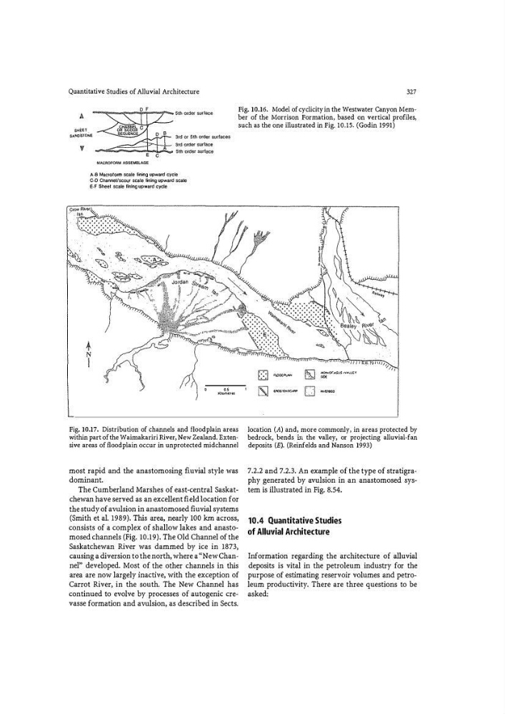
Fig. 10.16. Model of cyclicity in the Westwater Canyon Member of the Morrison Formation, based on vertical profiles�
such as the one illustrated in Fig. 10.15. (Godin 1991)
A · B Mac10f01m scale fining upward cycle
C·D Channel/scour scale fining upward scale
E-F Sheet scale fining upward cycle
'·'
Kll crnw•s
Fig. 10.17. Distribution of channels and floodplain areas
within part of the Waimakariri River, New Zealand. Extensive areas of floodplain occur in unprotected midchannel
most rapid and the anastomosing fluvial style was
dominant.
The Cumberland Marshes of east-central Saskatchewan have served as an excellent field location for
the study of avulsion in anastomosed fl uvial systems
(Smith et al. 1989). This area, nearly 100 km across,
consists of a complex of shallow lakes and anasto�
mosed channels (Fig. 10.19). The Old Channel of the
Saskatchewan River was dammed by ice in 1873,
causing a diversion to the north, where a "New Channel" developed. Most of the other channels in this
area are now largely inactive, with the exception of
Carrot River, in the south. The New Channel has
continued to evolve by processes of autogenic crevasse formation and avulsion, as described in Sects.
D
-�
[§J
M!)f>i<;lf'A(;IJ$ IVA\,��"{
=
.
IS]
��0
-
location (A) and, more commonly, in areas protected by
bedrock, bends in the valley, or projecting alluvial-fan
deposits (E). (Reinfelds and Nanson 1993)
7.2.2 and 7.2.3. An example of the type of stratigraphy generated by avulsion in an anastomosed system is illustrated in Fig. 8.54.
10.4 Quantitative Studies
of Alluvial Architecture
Information regarding the architecture of alluvial
deposits is vital in the petroleum industry for the
purpose of estimating reservoir volumes and petroleum productivity. There are three questions to be
asked:
327
SHEET
SANDSiONE
Fig. 10.16. Model of cyclicity in the Westwater Canyon Member of the Morrison Formation, based on vertical profiles�
such as the one illustrated in Fig. 10.15. (Godin 1991)
A · B Mac10f01m scale fining upward cycle
C·D Channel/scour scale fining upward scale
E-F Sheet scale fining upward cycle
'·'
Kll crnw•s
Fig. 10.17. Distribution of channels and floodplain areas
within part of the Waimakariri River, New Zealand. Extensive areas of floodplain occur in unprotected midchannel
most rapid and the anastomosing fluvial style was
dominant.
The Cumberland Marshes of east-central Saskatchewan have served as an excellent field location for
the study of avulsion in anastomosed fl uvial systems
(Smith et al. 1989). This area, nearly 100 km across,
consists of a complex of shallow lakes and anasto�
mosed channels (Fig. 10.19). The Old Channel of the
Saskatchewan River was dammed by ice in 1873,
causing a diversion to the north, where a "New Channel" developed. Most of the other channels in this
area are now largely inactive, with the exception of
Carrot River, in the south. The New Channel has
continued to evolve by processes of autogenic crevasse formation and avulsion, as described in Sects.
D
-�
[§J
M!)f>i<;lf'A(;IJ$ IVA\,��"{
=
.
IS]
��0
-
location (A) and, more commonly, in areas protected by
bedrock, bends in the valley, or projecting alluvial-fan
deposits (E). (Reinfelds and Nanson 1993)
7.2.2 and 7.2.3. An example of the type of stratigraphy generated by avulsion in an anastomosed system is illustrated in Fig. 8.54.
10.4 Quantitative Studies
of Alluvial Architecture
Information regarding the architecture of alluvial
deposits is vital in the petroleum industry for the
purpose of estimating reservoir volumes and petroleum productivity. There are three questions to be
asked: