

320
Fluvial Depositional Systems and Autogenic-sedimentary Controls
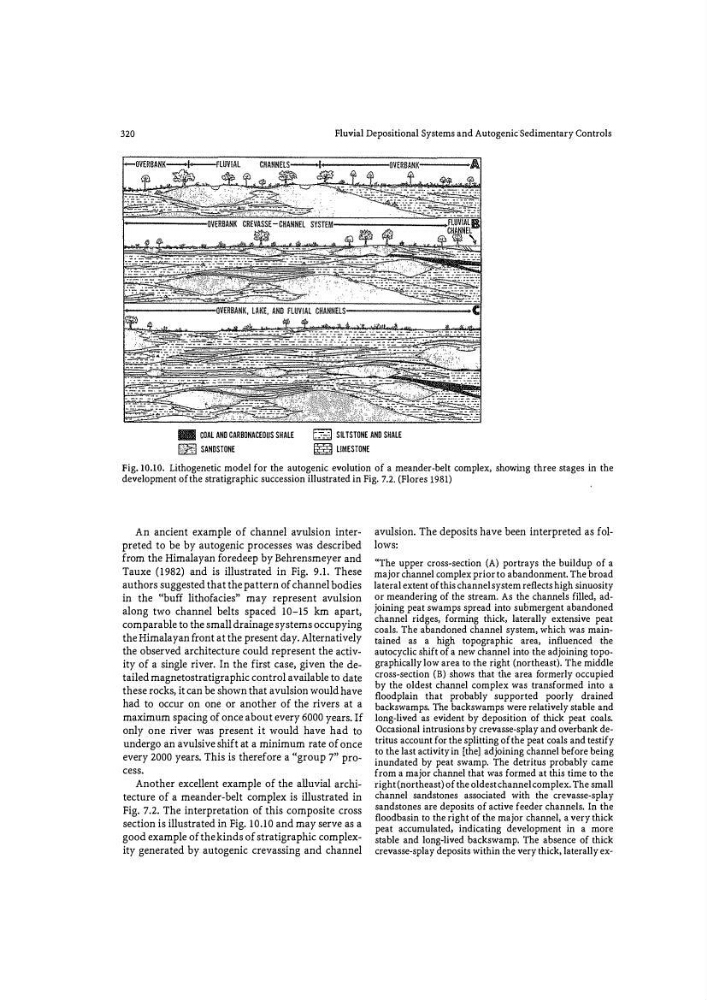
IIII I! GOAL AND CARBONACEOUS SHALE
IJilijJ SANDSTONE
� SILTSTONE AND SHALE
� LIMESTONE
Fig. 10.10. Lithogenetic model for the autogenic evolution of a meander�belt complex, showillg three stages in the
development of the stratigraphic succession illustrated in Fig. 7 .2. (Flores 1981)
An ancient example of channel avulsion interpreted to be by autogenic processes was described
from the Himalayan fo redeep by Behrensmeyer and
Tauxe (1982) and is illustrated in Fig. 9.1. These
authors suggested that the pattern of channel bodies
in the '(buff lithofacies" may represent avulsion
along two channel belts spaced 10-15 km apart,
comparable to the small drainage systems occupying
the Himalayan front at the present day. Alternatively
the observed architecture could represent the activ�
ity of a single river. In the first case, given the detailed magnetostratigraphic control available to date
these rocks, it can be shown that avulsion would have
had to occur on one or another of the rivers at a
maximum spacing of once about every 6000 years. If
only one river was present it would have had to
undergo an avulsive shift at a minimum rate of once
every 2000 years. This is therefore a "group 7" process.
Another excellent example of the alluvial architecture of a meander-belt complex is illustrated in
Fig. 7.2. The interpretation of this composite cross
section is illustrated in Fig. 10.10 and may serve as a
good example of the kinds of stratigraphic complexity generated by autogenic crevassing and channel
avulsion. The deposits have been interpreted as follows:
"The upper cross-section (A) portrays the buildup of a
major channel complex prior to abandonment. The broad
lateral extent of this channel system reflects high sinuosity
or meandering of the stream. As the channels filled, adjoining peat sWamps spread into su b mergent abandoned
channel ridges, forming thick, laterally extensive peat
coals. The abandoned channel system, which was maintained as a high topographic area, influenced the
autocyclic shift of a new channel into the adjoining topographically low area to the right (northeast). The middle
cross-section (B) shows that the area fo rmerly occupied
by the oldest channel complex was transformed into a
floodplain that probably supported poorly drained
backswamps. The backswamps were relatively stable and
long-lived as evident by deposition of thick peat coals.
Occasional intrusions by crevasse-splay and overbank detritus account for the splitting of the peat coals and testify
to the last activity in [the] adjoining channel before being
inundated by peat swamp. The detritus probably came
from a major channel that was formed at this time to the
right (northeast) of the oldest channel complex. The small
channel sandstones associated with the crevasse-splay
sandstones are deposits of active feeder channels. In the
floodbasin to the right of the major channel, a very thick
peat accumulated, indicating development in a more
stable and long�lived backswamp. The absence of thick
crevasse-splay deposits within the very thick, laterally ex�
Fluvial Depositional Systems and Autogenic-sedimentary Controls
IIII I! GOAL AND CARBONACEOUS SHALE
IJilijJ SANDSTONE
� SILTSTONE AND SHALE
� LIMESTONE
Fig. 10.10. Lithogenetic model for the autogenic evolution of a meander�belt complex, showillg three stages in the
development of the stratigraphic succession illustrated in Fig. 7 .2. (Flores 1981)
An ancient example of channel avulsion interpreted to be by autogenic processes was described
from the Himalayan fo redeep by Behrensmeyer and
Tauxe (1982) and is illustrated in Fig. 9.1. These
authors suggested that the pattern of channel bodies
in the '(buff lithofacies" may represent avulsion
along two channel belts spaced 10-15 km apart,
comparable to the small drainage systems occupying
the Himalayan front at the present day. Alternatively
the observed architecture could represent the activ�
ity of a single river. In the first case, given the detailed magnetostratigraphic control available to date
these rocks, it can be shown that avulsion would have
had to occur on one or another of the rivers at a
maximum spacing of once about every 6000 years. If
only one river was present it would have had to
undergo an avulsive shift at a minimum rate of once
every 2000 years. This is therefore a "group 7" process.
Another excellent example of the alluvial architecture of a meander-belt complex is illustrated in
Fig. 7.2. The interpretation of this composite cross
section is illustrated in Fig. 10.10 and may serve as a
good example of the kinds of stratigraphic complexity generated by autogenic crevassing and channel
avulsion. The deposits have been interpreted as follows:
"The upper cross-section (A) portrays the buildup of a
major channel complex prior to abandonment. The broad
lateral extent of this channel system reflects high sinuosity
or meandering of the stream. As the channels filled, adjoining peat sWamps spread into su b mergent abandoned
channel ridges, forming thick, laterally extensive peat
coals. The abandoned channel system, which was maintained as a high topographic area, influenced the
autocyclic shift of a new channel into the adjoining topographically low area to the right (northeast). The middle
cross-section (B) shows that the area fo rmerly occupied
by the oldest channel complex was transformed into a
floodplain that probably supported poorly drained
backswamps. The backswamps were relatively stable and
long-lived as evident by deposition of thick peat coals.
Occasional intrusions by crevasse-splay and overbank detritus account for the splitting of the peat coals and testify
to the last activity in [the] adjoining channel before being
inundated by peat swamp. The detritus probably came
from a major channel that was formed at this time to the
right (northeast) of the oldest channel complex. The small
channel sandstones associated with the crevasse-splay
sandstones are deposits of active feeder channels. In the
floodbasin to the right of the major channel, a very thick
peat accumulated, indicating development in a more
stable and long�lived backswamp. The absence of thick
crevasse-splay deposits within the very thick, laterally ex�