

Methods of Correlation and Mapping
. .
s,
..
'·
. .
s,
I
'
•no_.n ,• ooonrstt
1? 0(" ��·
'
11
'\"
•1"
'
)
O!U
•
1'?
W{�:�( O . . ( .. 0(
?t
vg�(o '""O!
)�
.t=�� · .. { . . 0(
........ ··-1.-. � ��� .. ,
'•
'·
,,
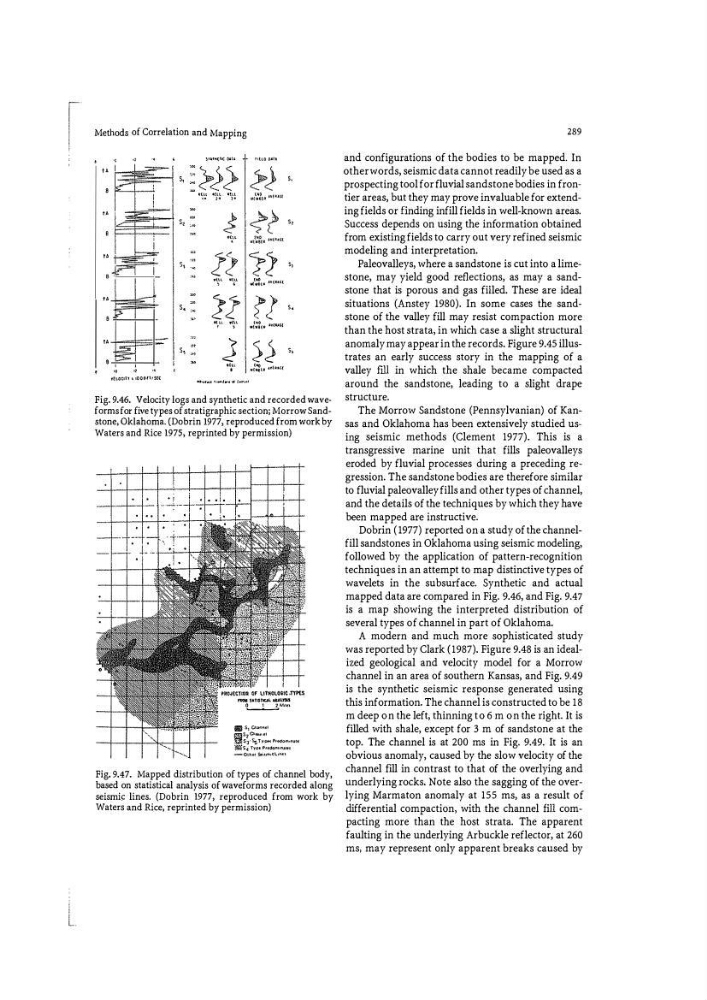
Fig. 9.46. Velocity logs and synthetic and recorded waveforms for five types of stratigraphic section; Morrow Sandstone, Oklahoma. (Dobrin 1977, reproduced from work by
Waters and Rice 1975, reprinted by permission)
IWiil UTI�T>tll 111.\ lT$1.1
'L.-...!_ __l.
"''"'
!!ill s, p,.,.. ".'
� �� ��.:. Pt
based on statistical analysis of waveforms recorded along
seismil= lines. (Dobrin 1977, reproduced from work by
Waters and Rice, reprinted by permission)
289
and configurations of the bodies to be mapped. In
other words, seismic data cannot readily be used as a
prospecting tool for fluvial sandstone bodies in frontier areas, but they may prove invaluable for extending fields or finding infill fields in well-known areas.
Success depends on using the information obtained
from existing fields to carry out very refined seismic
modeling and interpretation.
Paleovalleys, where a sandstone is cut into a limestone, may yield good refl ections, as may a sandstone that is porous and gas filled. These are ideal
situations (Anstey 1980). In some cases the sandstone of the valley fill may resist compaction more
than the host strata, in which case a slight structural
anomaly may appear in the records. Figure 9.45 illustrates an early success story in the mapping of a
valley fJll in which the shale became compacted
around the sandstone, leading to a slight drape
structure.
The Morrow Sandstone (Pennsylvanian) of Kansas and Oklahoma has been extensively studied us�
ing seismic methods (Clement 1977). This is a
transgresSive marine unit that fills paleovalleys
eroded by fluvial processes during a preceding regression. The sandstone bodies are therefore similar
to fluvial paleovalley fills and other types of channel,
and the details of the techniques by which they have
been mapped are instructive.
Dobrin ( 1977) reported on a study of the channelfill sandstones in Oklahoma using seismic modeling,
followed by the application of pattern-recognition
techniques in an attempt to map distinctive types of
wavelets in the subsurface. Synthetic and actual
mapped data are compared in Fig. 9.46, and Fig. 9.47
is a map showing the interpreted distribution of
several types of channel in part of Oklahoma.
A modern and much more sophisticated study
was reported by Clark (1987). Figure 9.48 is an idealized geological and velocity model for a Morrow
channel in an area of southern Kansas, and Fig. 9.49
is the synthetic seismic response generated using
this information. The channel is constructed to be 18
m deep on the left, thinning to 6 m on the right. It is
filled with shale, except for 3 m of sandstone at the
top. The channel is at 200 ms in Fig. 9.49. It is an
obvious anomaly, caused by the slow velocity of the
channel fill in contrast to that of the overlying and
underlying rocks. Note also the sagging of the overlying Marmaton anomaly at 155 ms, as a result of
differential compaction, with the channel fill compacting more than the host strata. The apparent
faulting in the underlying Arbuckle reflector, at 260
ms, may represent only apparent breaks caused by
. .
s,
..
'·
. .
s,
I
'
•no_.n ,• ooonrstt
1? 0(" ��·
'
11
'\"
•1"
'
)
O!U
•
1'?
W{�:�( O . . ( .. 0(
?t
vg�(o '""O!
)�
.t=�� · .. { . . 0(
........ ··-1.-. � ��� .. ,
'•
'·
,,
Fig. 9.46. Velocity logs and synthetic and recorded waveforms for five types of stratigraphic section; Morrow Sandstone, Oklahoma. (Dobrin 1977, reproduced from work by
Waters and Rice 1975, reprinted by permission)
IWiil UTI�T>tll 111.\ lT$1.1
'L.-...!_ __l.
"''"'
!!ill s, p,.,.. ".'
� �� ��.:. Pt
based on statistical analysis of waveforms recorded along
seismil= lines. (Dobrin 1977, reproduced from work by
Waters and Rice, reprinted by permission)
289
and configurations of the bodies to be mapped. In
other words, seismic data cannot readily be used as a
prospecting tool for fluvial sandstone bodies in frontier areas, but they may prove invaluable for extending fields or finding infill fields in well-known areas.
Success depends on using the information obtained
from existing fields to carry out very refined seismic
modeling and interpretation.
Paleovalleys, where a sandstone is cut into a limestone, may yield good refl ections, as may a sandstone that is porous and gas filled. These are ideal
situations (Anstey 1980). In some cases the sandstone of the valley fill may resist compaction more
than the host strata, in which case a slight structural
anomaly may appear in the records. Figure 9.45 illustrates an early success story in the mapping of a
valley fJll in which the shale became compacted
around the sandstone, leading to a slight drape
structure.
The Morrow Sandstone (Pennsylvanian) of Kansas and Oklahoma has been extensively studied us�
ing seismic methods (Clement 1977). This is a
transgresSive marine unit that fills paleovalleys
eroded by fluvial processes during a preceding regression. The sandstone bodies are therefore similar
to fluvial paleovalley fills and other types of channel,
and the details of the techniques by which they have
been mapped are instructive.
Dobrin ( 1977) reported on a study of the channelfill sandstones in Oklahoma using seismic modeling,
followed by the application of pattern-recognition
techniques in an attempt to map distinctive types of
wavelets in the subsurface. Synthetic and actual
mapped data are compared in Fig. 9.46, and Fig. 9.47
is a map showing the interpreted distribution of
several types of channel in part of Oklahoma.
A modern and much more sophisticated study
was reported by Clark (1987). Figure 9.48 is an idealized geological and velocity model for a Morrow
channel in an area of southern Kansas, and Fig. 9.49
is the synthetic seismic response generated using
this information. The channel is constructed to be 18
m deep on the left, thinning to 6 m on the right. It is
filled with shale, except for 3 m of sandstone at the
top. The channel is at 200 ms in Fig. 9.49. It is an
obvious anomaly, caused by the slow velocity of the
channel fill in contrast to that of the overlying and
underlying rocks. Note also the sagging of the overlying Marmaton anomaly at 155 ms, as a result of
differential compaction, with the channel fill compacting more than the host strata. The apparent
faulting in the underlying Arbuckle reflector, at 260
ms, may represent only apparent breaks caused by