

276
The Stratigraphic Architecture of Fluvial Depositional Systems
LOG FACIES TYPES FOR THE NARRABEEN GROUP
(gamma log)
A
&a!dDiakl-d;,til'lel
$;1/ld$!(lnl/tl\nlo
!IIWy"itt tert>added
§_� �
Oiwet(l
Sladted/wna�garn.ate\1
Slocl
�fi�
o.and:l!Oil(l bOdies
&Wcle
6
i
�
"'"" �
MJ!Iiple tt.n
tnr.g-ww ..,.d
�C)'Cie$
:s.atlCbtonoefrru:lotcnc
Lloydminster area, Alberta (Fig. 9.29). Hamilton and
Galloway (1989) discriminated various fluvial styles
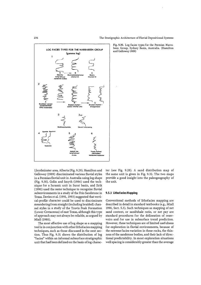
in a Permian fluvial unit in Australia using log shape
(Fig. 9.30). Golin and Smyth (1986) used the technique for a Jurassic unit in Surat basin, and Jirik
( 1990) used the same technique to recognize fluvial
subenvironments in a study of the Frio Sandstone in
Texas. Davies et al. (1991, 1993) suggested that vertical-prome· character could be used to discriminate
meandering from straight (including braided) channel styles in a study of the Travis Peak Formation
(Lower Cretaceous) of east Texas, although this type
of approach may not always be reliable, as argued by
Miall (1980).
The most effective use oflog shape as a mapping
tool is in conjunction with other lithofacies mapping
techniques, such as those discussed in the next section. Thus Fig. 9.31 shows the distribution of log
"facies" within an informal subsurface stratigraphic
unit that had been defined on the basis oflog characFig. 9.30. Log fades types for the Permian Narrabeen Group, Sydney Basin, Australia. (Hamilton
and Galloway 1989)
ter (see Fig. 9.28). A sand distribution map of
the same unit is given in Fig. 9.32. The two maps
provide a good insight into the paleogeography of
the unit.
9.5.3 Lithofacies Mapping
Conventional methods of lithofacies mapping are
described in detail in standard textbooks (e.g., Miail
1990, Sect. 5.3). Such techniques as mapping of net
sand content, or sand/shale ratio, or net pay are
standard procedures for the delineation of reservoirs and for use in subsurface trend prediction.
However, these techniques are of limited usefulness
for exploration in fluvial environments, because of
the extreme facies variation in these rocks, the thinness of the sandstone bodies, and their lack of directional predictability. In most exploration situations
well spacing is considerably greater than the average
The Stratigraphic Architecture of Fluvial Depositional Systems
LOG FACIES TYPES FOR THE NARRABEEN GROUP
(gamma log)
A
&a!dDiakl-d;,til'lel
$;1/ld$!(lnl/tl\nlo
!IIWy"itt tert>added
§_� �
Oiwet(l
Sladted/wna�garn.ate\1
Slocl
�fi�
o.and:l!Oil(l bOdies
&Wcle
6
i
�
"'"" �
MJ!Iiple tt.n
tnr.g-ww ..,.d
�C)'Cie$
:s.atlCbtonoefrru:lotcnc
Lloydminster area, Alberta (Fig. 9.29). Hamilton and
Galloway (1989) discriminated various fluvial styles
in a Permian fluvial unit in Australia using log shape
(Fig. 9.30). Golin and Smyth (1986) used the technique for a Jurassic unit in Surat basin, and Jirik
( 1990) used the same technique to recognize fluvial
subenvironments in a study of the Frio Sandstone in
Texas. Davies et al. (1991, 1993) suggested that vertical-prome· character could be used to discriminate
meandering from straight (including braided) channel styles in a study of the Travis Peak Formation
(Lower Cretaceous) of east Texas, although this type
of approach may not always be reliable, as argued by
Miall (1980).
The most effective use oflog shape as a mapping
tool is in conjunction with other lithofacies mapping
techniques, such as those discussed in the next section. Thus Fig. 9.31 shows the distribution of log
"facies" within an informal subsurface stratigraphic
unit that had been defined on the basis oflog characFig. 9.30. Log fades types for the Permian Narrabeen Group, Sydney Basin, Australia. (Hamilton
and Galloway 1989)
ter (see Fig. 9.28). A sand distribution map of
the same unit is given in Fig. 9.32. The two maps
provide a good insight into the paleogeography of
the unit.
9.5.3 Lithofacies Mapping
Conventional methods of lithofacies mapping are
described in detail in standard textbooks (e.g., Miail
1990, Sect. 5.3). Such techniques as mapping of net
sand content, or sand/shale ratio, or net pay are
standard procedures for the delineation of reservoirs and for use in subsurface trend prediction.
However, these techniques are of limited usefulness
for exploration in fluvial environments, because of
the extreme facies variation in these rocks, the thinness of the sandstone bodies, and their lack of directional predictability. In most exploration situations
well spacing is considerably greater than the average