

Methods of Correlation and Mapping
consisting of channel sandstones and interbedded
fl oodplain units with calcretes and including eight
airfall tuffs. They were able to map the tuffs over a
lateral distance of more than 30 km, and this enabled
them to subdivide the succession into eight units
ranging from about 2 to 13 m in thickness. Each unit
represents an average of about 8000 years of sedi�
mentation, so that very detailed architectural reconstructions are possible from these rocks. Figure 9.25
shows the architectural summary, and the details of
one of the depositional units is given in Fig. 9.26. In
this interval a major channel up to 10 m deep incises
the alluvial plain, and is only partially filled with
typical channel-fill sand lithofacies. This led Allen
and Williams (1982) to suggest that the channel in
fact represents an incised valley formed during an
interval ofbase-level lowering, and that the channels
that subsequently filled it with sediment were on a
smaller scale. Note the mature pedogenic calcretes
that blanketed the area prior to the deposition of tuff
F.
Individual coals and paleosols (discussed in
Sects. 7.4.1 and 7.4.2) may extend for tens of kilometers across a floodplain and are therefore among the
most laterally extensive and mappable units within
fluvial systems. For example, Fig. 7.2 illustrates a
coal-bearing alluvial succession in Wyoming and
Montana; Fig. 9.26 illustrates a thick and areally
extensive calcrete unit. Nemec (1988) argued that
because coal seams are laterally persistent and can
be correlated over wide areas, they can be used to
examine the details of differential subsidence within
a basin. He developed a form of graphic correlation
between coal seams to be used for this purpose and
demonstrated the technique using detailed correlaSHALE
CONGLOMCRATE
273
tion profiles from the Carboniferous South Wales
Basin (from Woodland and Evans 1964).
As discussed in detail in Chap. 13, base-level
changes may lead to the generation of widespread
units reflecting regional increases or decreases in
accommodation space. Coal seams and paleosols are
commonly deposited in response to such base-level
changes. Estuarine and lacustrine flooding during
base-level rise can generate distinctive tidal sand
bodies and widespread shales, the study of which can
aid in the definition and interpretation of nonmarine sequences.
9.5.2 Wireline Logs
The recognition of characteristic log «shapes" and
distinctive vertical-profile character may be a useful
tool for correlation purposes and an aid for interpreting fluvial style. The technique is almost as old as
modern sedimentology itself (e.g., Nanz 1954), as
noted in Chap. 2. The technique depends on the
distinctiveness of the vertical profile through a sandstone body and on our ability to interpret this profile
in terms of depositional processes and environment.
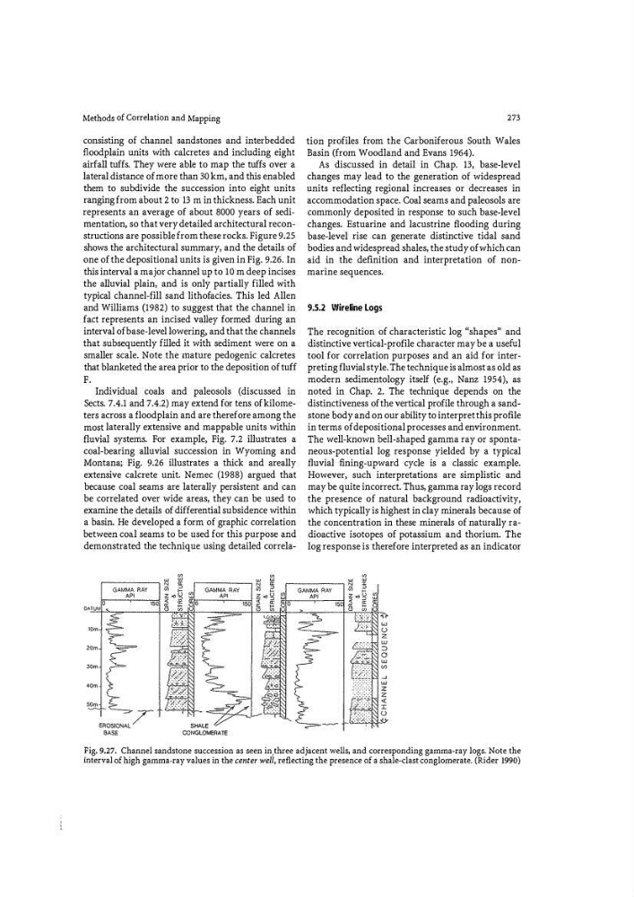
The well-known bell-shaped gamma ray or spontaneous-potential log response yielded by a typical
fluvial fi ning-upward cycle is a classic example.
However, such interpretations are simplistic and
may be quite incorrect. Thus) gamma ray logs record
the presence of natural background radioactivity,
which typically is highest in clay minerals because of
the concentration in these minerals of naturally radioactive isotopes of potassium and thorium. The
log response is therefore interpreted as an indicator
�ig. 9.27. Channel sandstone succession as seen in,three adjacent wells) and corresponding gamma-ray logs. Note the
mterval of high gamma�ray values in the center well, reflecting the presence of a shale�clast conglomerate. (Rider 1990)
consisting of channel sandstones and interbedded
fl oodplain units with calcretes and including eight
airfall tuffs. They were able to map the tuffs over a
lateral distance of more than 30 km, and this enabled
them to subdivide the succession into eight units
ranging from about 2 to 13 m in thickness. Each unit
represents an average of about 8000 years of sedi�
mentation, so that very detailed architectural reconstructions are possible from these rocks. Figure 9.25
shows the architectural summary, and the details of
one of the depositional units is given in Fig. 9.26. In
this interval a major channel up to 10 m deep incises
the alluvial plain, and is only partially filled with
typical channel-fill sand lithofacies. This led Allen
and Williams (1982) to suggest that the channel in
fact represents an incised valley formed during an
interval ofbase-level lowering, and that the channels
that subsequently filled it with sediment were on a
smaller scale. Note the mature pedogenic calcretes
that blanketed the area prior to the deposition of tuff
F.
Individual coals and paleosols (discussed in
Sects. 7.4.1 and 7.4.2) may extend for tens of kilometers across a floodplain and are therefore among the
most laterally extensive and mappable units within
fluvial systems. For example, Fig. 7.2 illustrates a
coal-bearing alluvial succession in Wyoming and
Montana; Fig. 9.26 illustrates a thick and areally
extensive calcrete unit. Nemec (1988) argued that
because coal seams are laterally persistent and can
be correlated over wide areas, they can be used to
examine the details of differential subsidence within
a basin. He developed a form of graphic correlation
between coal seams to be used for this purpose and
demonstrated the technique using detailed correlaSHALE
CONGLOMCRATE
273
tion profiles from the Carboniferous South Wales
Basin (from Woodland and Evans 1964).
As discussed in detail in Chap. 13, base-level
changes may lead to the generation of widespread
units reflecting regional increases or decreases in
accommodation space. Coal seams and paleosols are
commonly deposited in response to such base-level
changes. Estuarine and lacustrine flooding during
base-level rise can generate distinctive tidal sand
bodies and widespread shales, the study of which can
aid in the definition and interpretation of nonmarine sequences.
9.5.2 Wireline Logs
The recognition of characteristic log «shapes" and
distinctive vertical-profile character may be a useful
tool for correlation purposes and an aid for interpreting fluvial style. The technique is almost as old as
modern sedimentology itself (e.g., Nanz 1954), as
noted in Chap. 2. The technique depends on the
distinctiveness of the vertical profile through a sandstone body and on our ability to interpret this profile
in terms of depositional processes and environment.
The well-known bell-shaped gamma ray or spontaneous-potential log response yielded by a typical
fluvial fi ning-upward cycle is a classic example.
However, such interpretations are simplistic and
may be quite incorrect. Thus) gamma ray logs record
the presence of natural background radioactivity,
which typically is highest in clay minerals because of
the concentration in these minerals of naturally radioactive isotopes of potassium and thorium. The
log response is therefore interpreted as an indicator
�ig. 9.27. Channel sandstone succession as seen in,three adjacent wells) and corresponding gamma-ray logs. Note the
mterval of high gamma�ray values in the center well, reflecting the presence of a shale�clast conglomerate. (Rider 1990)