

272
The Stratigraphic Architecture of Fluvial Depositional Systems
v
1
coarse
sequence 5
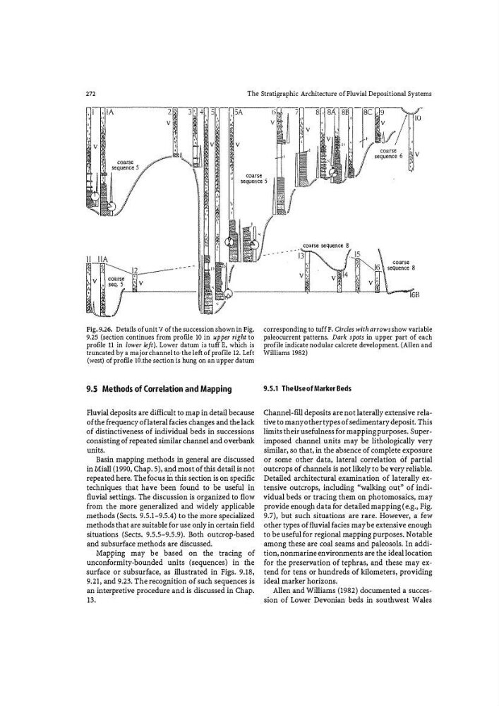
Fig.·9.26. Details of unit V of the succession shown in Fig.
9.25 (section continues from profile 10 in upper right to
proflle 11 in lower left). Lower datum is tuff E, which is
truncated by a major channel to--the left of proflle 12. Left
(west) of prof.rle lO�the section is hung on an upper datum
9.5 Methods of Correlation and Mapping
Fluvial deposits are difficult to map in detail because
of the frequency of lateral facies changes and the lack
of distinctiveness of individual beds in successions
consisting of repeated similar channel and overbank
units.
Basin mapping methods in general are discussed
in Miall (1990, Chap. 5), and most of this detail is not
repeated here. The f�)CUS in this section is on specific
techniques that have been found to be useful in
fluvial settings. The discussion is organized to flow
from tbe more generalized and widely applicable
methods (Sects. 9.5.1-9.5.4) to tbe more specialized
methods that are suitable for use only in certain field
situations (Sects. 9.5.5-9.5.9). Both outcrop-based
and subsurface methods are discussed.
Mapping may be based on the tracing of
unconformity-bounded units (sequences) in the
surface or subsurface, as illustrated in Figs. 9.18,
9.21, and 9.23. The recognition of such sequences is
an interpretive procedure and is discussed in Chap.
13.
coarse sequence 8.
v
,',
,,
,
coarse
. sequence 8
corresponding to tuff F. Circles with arrows show variable
paleocurrent patterns. Dark spots in upper part of each
profile indicate nodular calcrete development. (Allen and
Williams 1982)
9.5.1 The Use of Marker Beds
Channel-fill deposits are not laterally extensive relative to many other types of sedimentary deposit. This
limits their usefulness for mapping purposes. Superimposed channel uuits may be lithologically very
similar, so that, in the absence of complete exposure
or some other data, lateral correlation Of partial
outcrops of channels is not likely to be very reliable.
Detailed architectural examination of laterally extensive outcrops, including "walking out" of individual beds or tracing them on photomosaics, may
provide enough data for detailed mapping (e .g., Fig.
9.7), but such situations are rare. However, a few
other types of fluvial facies may be extensive enough
to be useful for regional mapping purposes. Notable
among these are coal seams and paleosols. In addition, nonmarine environments are the ideal location
for the preservation of tephras, and these may extend for tens or hundreds of kilometers, providing
ideal marker horizons.
Allen and Wi lliams (1982) documented a succession of Lower Devonian beds in southwest Wales
The Stratigraphic Architecture of Fluvial Depositional Systems
v
1
coarse
sequence 5
Fig.·9.26. Details of unit V of the succession shown in Fig.
9.25 (section continues from profile 10 in upper right to
proflle 11 in lower left). Lower datum is tuff E, which is
truncated by a major channel to--the left of proflle 12. Left
(west) of prof.rle lO�the section is hung on an upper datum
9.5 Methods of Correlation and Mapping
Fluvial deposits are difficult to map in detail because
of the frequency of lateral facies changes and the lack
of distinctiveness of individual beds in successions
consisting of repeated similar channel and overbank
units.
Basin mapping methods in general are discussed
in Miall (1990, Chap. 5), and most of this detail is not
repeated here. The f�)CUS in this section is on specific
techniques that have been found to be useful in
fluvial settings. The discussion is organized to flow
from tbe more generalized and widely applicable
methods (Sects. 9.5.1-9.5.4) to tbe more specialized
methods that are suitable for use only in certain field
situations (Sects. 9.5.5-9.5.9). Both outcrop-based
and subsurface methods are discussed.
Mapping may be based on the tracing of
unconformity-bounded units (sequences) in the
surface or subsurface, as illustrated in Figs. 9.18,
9.21, and 9.23. The recognition of such sequences is
an interpretive procedure and is discussed in Chap.
13.
coarse sequence 8.
v
,',
,,
,
coarse
. sequence 8
corresponding to tuff F. Circles with arrows show variable
paleocurrent patterns. Dark spots in upper part of each
profile indicate nodular calcrete development. (Allen and
Williams 1982)
9.5.1 The Use of Marker Beds
Channel-fill deposits are not laterally extensive relative to many other types of sedimentary deposit. This
limits their usefulness for mapping purposes. Superimposed channel uuits may be lithologically very
similar, so that, in the absence of complete exposure
or some other data, lateral correlation Of partial
outcrops of channels is not likely to be very reliable.
Detailed architectural examination of laterally extensive outcrops, including "walking out" of individual beds or tracing them on photomosaics, may
provide enough data for detailed mapping (e .g., Fig.
9.7), but such situations are rare. However, a few
other types of fluvial facies may be extensive enough
to be useful for regional mapping purposes. Notable
among these are coal seams and paleosols. In addition, nonmarine environments are the ideal location
for the preservation of tephras, and these may extend for tens or hundreds of kilometers, providing
ideal marker horizons.
Allen and Wi lliams (1982) documented a succession of Lower Devonian beds in southwest Wales