

210
Fluvial Styles and Facies Models
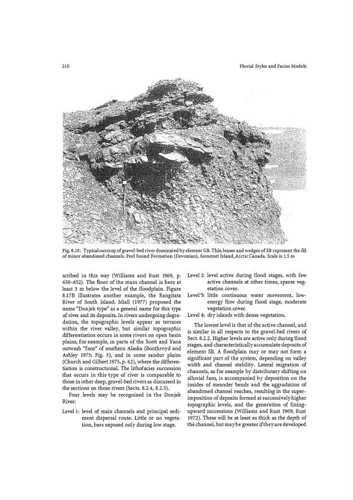
Fig. 8.15. Typical outcrop of gravel-bed river dominated by element GB. Thin lenses and wedges of SB represent the f ill
of minor abandoned channels. Peel Sound Formation (Devonian}, Somerset Island, Arctic Canada. Scale is 1.5 m
scribed in this way (Williams and Rust 1969, p.
650-652). The floor of the main channel is here at
least 3 m below the level of the floodplain. Figure
8.17B illustrates another example, the Rangitata
River of South Island. Miall (1977) proposed the
name "Donjek type" as a general name for this type
of river and its deposits. In rivers undergoing degradation, the topographic levels appear as terraces
within the river valley, but similar topographic
differentiation occurs in some rivers on open basin
plains, for example, in parts of the Scott and Yarra
outwash "fans" of southern Alaska (Boothroyd and
Ashley 1975; Fig. 3), and in some sandur plains
(Church and Gilbert 1975, p. 62), where the differentiation is constructional. The lithofacies succession
that occurs in this type of river is comparable to
those in other deep, gravel�bed rivers as discussed in
the sections on those rivers (Sects. 8.2.4, 8.2.5).
Four levels may be recognized in the Donjek
River:
Level l: level of main channels and principal sediw
ment dispersal route. Little or no vegeta�
tion, bars exposed only during low stage.
Level 2: level active during flood stages, with few
active channels at other times, sparse vegetation cover.
Level "3: little continuous water movement, lowenergy flow during flood stage, moderate
vegetation cover.
Level 4: dry islands with dense vegetation.
The lowest level is that of the active channel, and
is similar in all respects to the gravel-bed rivers of
Sect. 8.2.2. Higher levels are active only during flood
stages, and characteristically accumulate deposits of
element SB. A floodplain may or may not form a
significant part of the system, depending on valley
width and channel stability. Lateral migration of
channels, as for example by distributary shifting on
alluvial fans, is accompanied by deposition on the
insides of meander bends and the aggradation of
abandoned channel reaches, resulting in the superimposition of deposits fo rmed at successively higher
topographic levels, and the generation of finingupward successions (Williams and Rust 1969j Rust
1972). These will be at least as thick as the depth of
the channel, but may be greater if they are developed
Fluvial Styles and Facies Models
Fig. 8.15. Typical outcrop of gravel-bed river dominated by element GB. Thin lenses and wedges of SB represent the f ill
of minor abandoned channels. Peel Sound Formation (Devonian}, Somerset Island, Arctic Canada. Scale is 1.5 m
scribed in this way (Williams and Rust 1969, p.
650-652). The floor of the main channel is here at
least 3 m below the level of the floodplain. Figure
8.17B illustrates another example, the Rangitata
River of South Island. Miall (1977) proposed the
name "Donjek type" as a general name for this type
of river and its deposits. In rivers undergoing degradation, the topographic levels appear as terraces
within the river valley, but similar topographic
differentiation occurs in some rivers on open basin
plains, for example, in parts of the Scott and Yarra
outwash "fans" of southern Alaska (Boothroyd and
Ashley 1975; Fig. 3), and in some sandur plains
(Church and Gilbert 1975, p. 62), where the differentiation is constructional. The lithofacies succession
that occurs in this type of river is comparable to
those in other deep, gravel�bed rivers as discussed in
the sections on those rivers (Sects. 8.2.4, 8.2.5).
Four levels may be recognized in the Donjek
River:
Level l: level of main channels and principal sediw
ment dispersal route. Little or no vegeta�
tion, bars exposed only during low stage.
Level 2: level active during flood stages, with few
active channels at other times, sparse vegetation cover.
Level "3: little continuous water movement, lowenergy flow during flood stage, moderate
vegetation cover.
Level 4: dry islands with dense vegetation.
The lowest level is that of the active channel, and
is similar in all respects to the gravel-bed rivers of
Sect. 8.2.2. Higher levels are active only during flood
stages, and characteristically accumulate deposits of
element SB. A floodplain may or may not form a
significant part of the system, depending on valley
width and channel stability. Lateral migration of
channels, as for example by distributary shifting on
alluvial fans, is accompanied by deposition on the
insides of meander bends and the aggradation of
abandoned channel reaches, resulting in the superimposition of deposits fo rmed at successively higher
topographic levels, and the generation of finingupward successions (Williams and Rust 1969j Rust
1972). These will be at least as thick as the depth of
the channel, but may be greater if they are developed