

Bed-Bank Relationship and Flood Characterisation …
195
Z0
ZR
ZL
River bed
Right bank
LeŌ bank
Flow
direcƟon
a
b
c
d
e
f
g
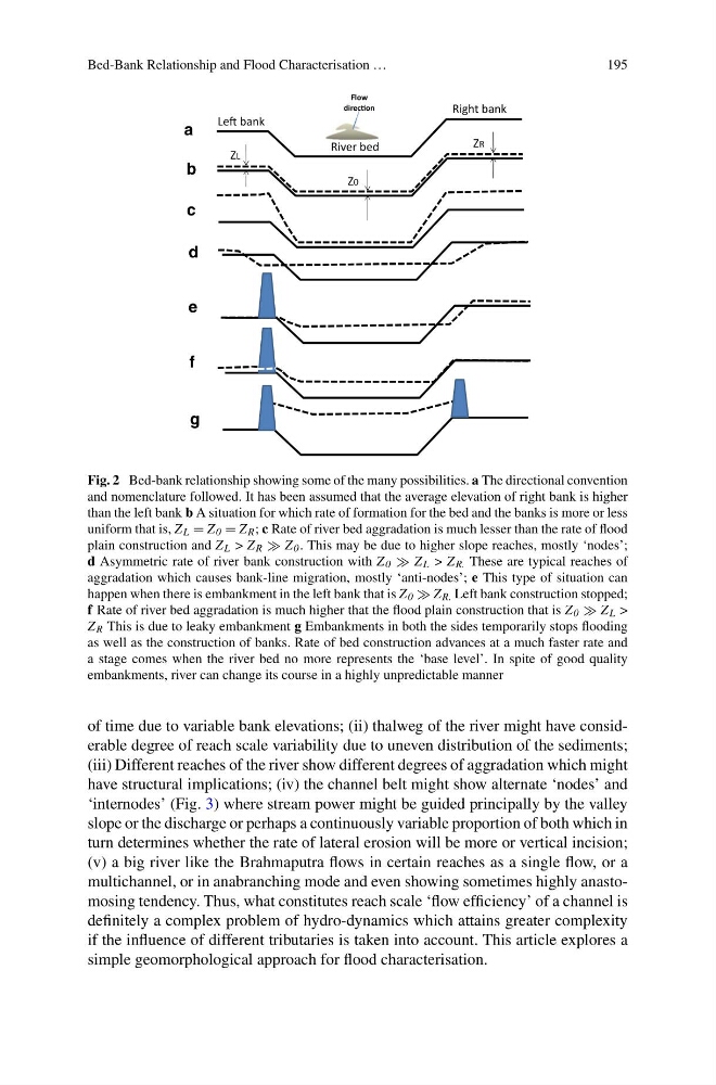
Fig. 2 Bed-bank relationship showing some of the many possibilities. a The directional convention
and nomenclature followed. It has been assumed that the average elevation of right bank is higher
than the left bank b A situation for which rate of formation for the bed and the banks is more or less
uniform that is, Z L = Z 0 = Z R ; c Rate of river bed aggradation is much lesser than the rate of flood
plain construction and Z L > Z R Z 0 . This may be due to higher slope reaches, mostly ‘nodes’;
d Asymmetric rate of river bank construction with Z 0 Z L > Z R. These are typical reaches of
aggradation which causes bank-line migration, mostly ‘anti-nodes’; e This type of situation can
happen when there is embankment in the left bank that is Z 0 Z R. Left bank construction stopped;
f Rate of river bed aggradation is much higher that the flood plain construction that is Z 0 Z L >
Z R This is due to leaky embankment g Embankments in both the sides temporarily stops flooding
as well as the construction of banks. Rate of bed construction advances at a much faster rate and
a stage comes when the river bed no more represents the ‘base level’. In spite of good quality
embankments, river can change its course in a highly unpredictable manner
of time due to variable bank elevations; (ii) thalweg of the river might have considerable degree of reach scale variability due to uneven distribution of the sediments;
(iii) Different reaches of the river show different degrees of aggradation which might
have structural implications; (iv) the channel belt might show alternate ‘nodes’ and
‘internodes’ (Fig. 3) where stream power might be guided principally by the valley
slope or the discharge or perhaps a continuously variable proportion of both which in
turn determines whether the rate of lateral erosion will be more or vertical incision;
(v) a big river like the Brahmaputra flows in certain reaches as a single flow, or a
multichannel, or in anabranching mode and even showing sometimes highly anastomosing tendency. Thus, what constitutes reach scale ‘flow efficiency’ of a channel is
definitely a complex problem of hydro-dynamics which attains greater complexity
if the influence of different tributaries is taken into account. This article explores a
simple geomorphological approach for flood characterisation.
195
Z0
ZR
ZL
River bed
Right bank
LeŌ bank
Flow
direcƟon
a
b
c
d
e
f
g
Fig. 2 Bed-bank relationship showing some of the many possibilities. a The directional convention
and nomenclature followed. It has been assumed that the average elevation of right bank is higher
than the left bank b A situation for which rate of formation for the bed and the banks is more or less
uniform that is, Z L = Z 0 = Z R ; c Rate of river bed aggradation is much lesser than the rate of flood
plain construction and Z L > Z R Z 0 . This may be due to higher slope reaches, mostly ‘nodes’;
d Asymmetric rate of river bank construction with Z 0 Z L > Z R. These are typical reaches of
aggradation which causes bank-line migration, mostly ‘anti-nodes’; e This type of situation can
happen when there is embankment in the left bank that is Z 0 Z R. Left bank construction stopped;
f Rate of river bed aggradation is much higher that the flood plain construction that is Z 0 Z L >
Z R This is due to leaky embankment g Embankments in both the sides temporarily stops flooding
as well as the construction of banks. Rate of bed construction advances at a much faster rate and
a stage comes when the river bed no more represents the ‘base level’. In spite of good quality
embankments, river can change its course in a highly unpredictable manner
of time due to variable bank elevations; (ii) thalweg of the river might have considerable degree of reach scale variability due to uneven distribution of the sediments;
(iii) Different reaches of the river show different degrees of aggradation which might
have structural implications; (iv) the channel belt might show alternate ‘nodes’ and
‘internodes’ (Fig. 3) where stream power might be guided principally by the valley
slope or the discharge or perhaps a continuously variable proportion of both which in
turn determines whether the rate of lateral erosion will be more or vertical incision;
(v) a big river like the Brahmaputra flows in certain reaches as a single flow, or a
multichannel, or in anabranching mode and even showing sometimes highly anastomosing tendency. Thus, what constitutes reach scale ‘flow efficiency’ of a channel is
definitely a complex problem of hydro-dynamics which attains greater complexity
if the influence of different tributaries is taken into account. This article explores a
simple geomorphological approach for flood characterisation.