

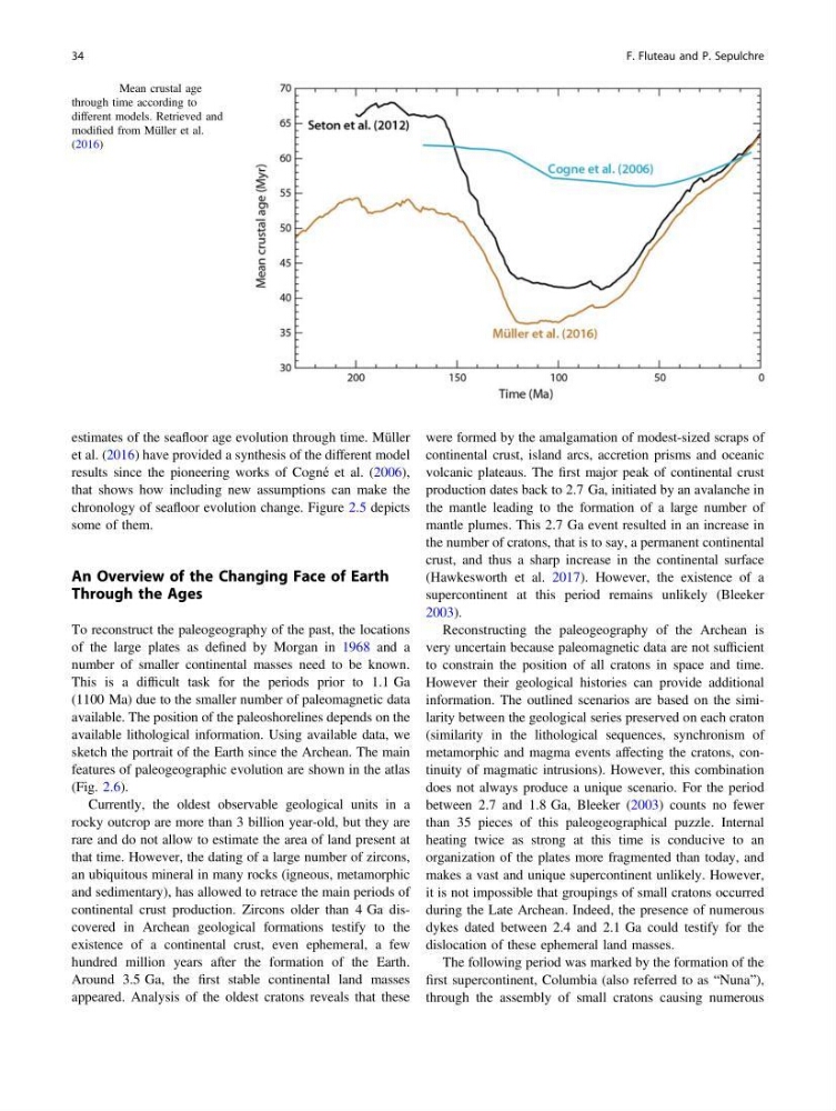
estimates of the seafloor age evolution through time. Müller
et al. (2016) have provided a synthesis of the different model
results since the pioneering works of Cogné et al. (2006),
that shows how including new assumptions can make the
chronology of seafloor evolution change. Figure 2.5 depicts
some of them.
An Overview of the Changing Face of Earth
Through the Ages
To reconstruct the paleogeography of the past, the locations
of the large plates as defined by Morgan in 1968 and a
number of smaller continental masses need to be known.
This is a difficult task for the periods prior to 1.1 Ga
(1100 Ma) due to the smaller number of paleomagnetic data
available. The position of the paleoshorelines depends on the
available lithological information. Using available data, we
sketch the portrait of the Earth since the Archean. The main
features of paleogeographic evolution are shown in the atlas
(Fig. 2.6).
Currently, the oldest observable geological units in a
rocky outcrop are more than 3 billion year-old, but they are
rare and do not allow to estimate the area of land present at
that time. However, the dating of a large number of zircons,
an ubiquitous mineral in many rocks (igneous, metamorphic
and sedimentary), has allowed to retrace the main periods of
continental crust production. Zircons older than 4 Ga discovered in Archean geological formations testify to the
existence of a continental crust, even ephemeral, a few
hundred million years after the formation of the Earth.
Around 3.5 Ga, the first stable continental land masses
appeared. Analysis of the oldest cratons reveals that these
were formed by the amalgamation of modest-sized scraps of
continental crust, island arcs, accretion prisms and oceanic
volcanic plateaus. The first major peak of continental crust
production dates back to 2.7 Ga, initiated by an avalanche in
the mantle leading to the formation of a large number of
mantle plumes. This 2.7 Ga event resulted in an increase in
the number of cratons, that is to say, a permanent continental
crust, and thus a sharp increase in the continental surface
(Hawkesworth et al. 2017). However, the existence of a
supercontinent at this period remains unlikely (Bleeker
2003).
Reconstructing the paleogeography of the Archean is
very uncertain because paleomagnetic data are not sufficient
to constrain the position of all cratons in space and time.
However their geological histories can provide additional
information. The outlined scenarios are based on the similarity between the geological series preserved on each craton
(similarity in the lithological sequences, synchronism of
metamorphic and magma events affecting the cratons, continuity of magmatic intrusions). However, this combination
does not always produce a unique scenario. For the period
between 2.7 and 1.8 Ga, Bleeker (2003) counts no fewer
than 35 pieces of this paleogeographical puzzle. Internal
heating twice as strong at this time is conducive to an
organization of the plates more fragmented than today, and
makes a vast and unique supercontinent unlikely. However,
it is not impossible that groupings of small cratons occurred
during the Late Archean. Indeed, the presence of numerous
dykes dated between 2.4 and 2.1 Ga could testify for the
dislocation of these ephemeral land masses.
The following period was marked by the formation of the
first supercontinent, Columbia (also referred to as “Nuna”),
through the assembly of small cratons causing numerous
Fig. 2.5 Mean crustal age
through time according to
different models. Retrieved and
modified from Müller et al.
(2016)
34
F. Fluteau and P. Sepulchre
et al. (2016) have provided a synthesis of the different model
results since the pioneering works of Cogné et al. (2006),
that shows how including new assumptions can make the
chronology of seafloor evolution change. Figure 2.5 depicts
some of them.
An Overview of the Changing Face of Earth
Through the Ages
To reconstruct the paleogeography of the past, the locations
of the large plates as defined by Morgan in 1968 and a
number of smaller continental masses need to be known.
This is a difficult task for the periods prior to 1.1 Ga
(1100 Ma) due to the smaller number of paleomagnetic data
available. The position of the paleoshorelines depends on the
available lithological information. Using available data, we
sketch the portrait of the Earth since the Archean. The main
features of paleogeographic evolution are shown in the atlas
(Fig. 2.6).
Currently, the oldest observable geological units in a
rocky outcrop are more than 3 billion year-old, but they are
rare and do not allow to estimate the area of land present at
that time. However, the dating of a large number of zircons,
an ubiquitous mineral in many rocks (igneous, metamorphic
and sedimentary), has allowed to retrace the main periods of
continental crust production. Zircons older than 4 Ga discovered in Archean geological formations testify to the
existence of a continental crust, even ephemeral, a few
hundred million years after the formation of the Earth.
Around 3.5 Ga, the first stable continental land masses
appeared. Analysis of the oldest cratons reveals that these
were formed by the amalgamation of modest-sized scraps of
continental crust, island arcs, accretion prisms and oceanic
volcanic plateaus. The first major peak of continental crust
production dates back to 2.7 Ga, initiated by an avalanche in
the mantle leading to the formation of a large number of
mantle plumes. This 2.7 Ga event resulted in an increase in
the number of cratons, that is to say, a permanent continental
crust, and thus a sharp increase in the continental surface
(Hawkesworth et al. 2017). However, the existence of a
supercontinent at this period remains unlikely (Bleeker
2003).
Reconstructing the paleogeography of the Archean is
very uncertain because paleomagnetic data are not sufficient
to constrain the position of all cratons in space and time.
However their geological histories can provide additional
information. The outlined scenarios are based on the similarity between the geological series preserved on each craton
(similarity in the lithological sequences, synchronism of
metamorphic and magma events affecting the cratons, continuity of magmatic intrusions). However, this combination
does not always produce a unique scenario. For the period
between 2.7 and 1.8 Ga, Bleeker (2003) counts no fewer
than 35 pieces of this paleogeographical puzzle. Internal
heating twice as strong at this time is conducive to an
organization of the plates more fragmented than today, and
makes a vast and unique supercontinent unlikely. However,
it is not impossible that groupings of small cratons occurred
during the Late Archean. Indeed, the presence of numerous
dykes dated between 2.4 and 2.1 Ga could testify for the
dislocation of these ephemeral land masses.
The following period was marked by the formation of the
first supercontinent, Columbia (also referred to as “Nuna”),
through the assembly of small cratons causing numerous
Fig. 2.5 Mean crustal age
through time according to
different models. Retrieved and
modified from Müller et al.
(2016)
34
F. Fluteau and P. Sepulchre