

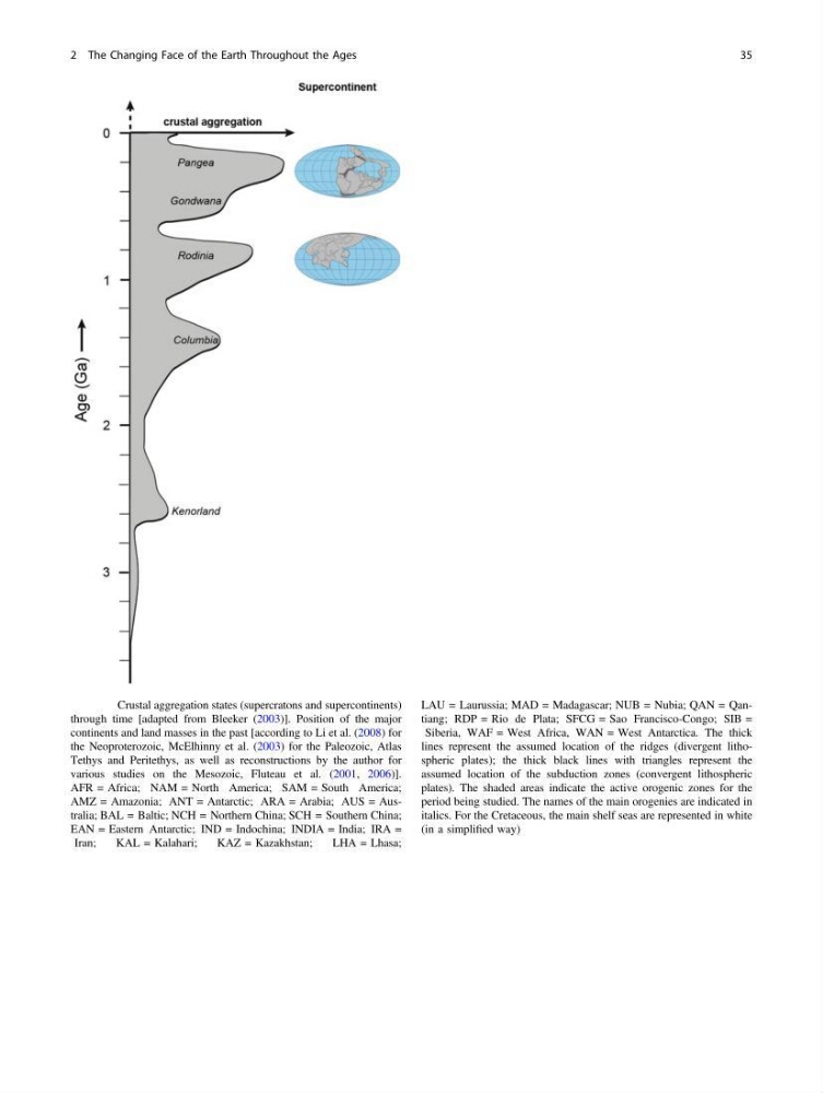
Fig. 2.6 Crustal aggregation states (supercratons and supercontinents)
through time [adapted from Bleeker (2003)]. Position of the major
continents and land masses in the past [according to Li et al. (2008) for
the Neoproterozoic, McElhinny et al. (2003) for the Paleozoic, Atlas
Tethys and Peritethys, as well as reconstructions by the author for
various studies on the Mesozoic, Fluteau et al. (2001, 2006)].
AFR = Africa; NAM = North America; SAM = South America;
AMZ = Amazonia; ANT = Antarctic; ARA = Arabia; AUS = Australia; BAL = Baltic; NCH = Northern China; SCH = Southern China;
EAN = Eastern Antarctic; IND = Indochina; INDIA = India; IRA =
Iran;
KAL = Kalahari;
KAZ = Kazakhstan;
LHA = Lhasa;
LAU = Laurussia; MAD = Madagascar; NUB = Nubia; QAN = Qantiang; RDP = Rio de Plata; SFCG = Sao Francisco-Congo; SIB =
Siberia, WAF = West Africa, WAN = West Antarctica. The thick
lines represent the assumed location of the ridges (divergent lithospheric plates); the thick black lines with triangles represent the
assumed location of the subduction zones (convergent lithospheric
plates). The shaded areas indicate the active orogenic zones for the
period being studied. The names of the main orogenies are indicated in
italics. For the Cretaceous, the main shelf seas are represented in white
(in a simplified way)
2 The Changing Face of the Earth Throughout the Ages
35
through time [adapted from Bleeker (2003)]. Position of the major
continents and land masses in the past [according to Li et al. (2008) for
the Neoproterozoic, McElhinny et al. (2003) for the Paleozoic, Atlas
Tethys and Peritethys, as well as reconstructions by the author for
various studies on the Mesozoic, Fluteau et al. (2001, 2006)].
AFR = Africa; NAM = North America; SAM = South America;
AMZ = Amazonia; ANT = Antarctic; ARA = Arabia; AUS = Australia; BAL = Baltic; NCH = Northern China; SCH = Southern China;
EAN = Eastern Antarctic; IND = Indochina; INDIA = India; IRA =
Iran;
KAL = Kalahari;
KAZ = Kazakhstan;
LHA = Lhasa;
LAU = Laurussia; MAD = Madagascar; NUB = Nubia; QAN = Qantiang; RDP = Rio de Plata; SFCG = Sao Francisco-Congo; SIB =
Siberia, WAF = West Africa, WAN = West Antarctica. The thick
lines represent the assumed location of the ridges (divergent lithospheric plates); the thick black lines with triangles represent the
assumed location of the subduction zones (convergent lithospheric
plates). The shaded areas indicate the active orogenic zones for the
period being studied. The names of the main orogenies are indicated in
italics. For the Cretaceous, the main shelf seas are represented in white
(in a simplified way)
2 The Changing Face of the Earth Throughout the Ages
35