

in particular the bathymetry, is decisive to correctly quantify
the cooling related to the change of configuration of the
seaways, but also that the freeze-up of the Antarctic requires,
in addition to paleogeographic changes, a significant
decrease of the atmospheric partial pressure of carbon dioxide from 1160 to 560 ppm (Lefebvre et al. 2012).
Numerous modelling studies have also focused on the
impact of the central American seaway (CAS) on climate.
Early works by Haug and Tiedemann (1998) had suggested
that the closure of the isthmus during the early Pliocene led to a
reorganization of the Atlantic thermohaline circulation.
Specifically, the authors inferred that the shallowing and closure of the CAS intensified the Gulf stream and strengthened
deep water formation in the northern Atlantic. More importantly these authors suggested that warmer SST induced by
this strengthening of the Gulf stream increased atmospheric
moisture content, and ultimately favored the Greenland ice
sheet growth. Later, numerous model experiments with open
CAS with various depth and width have been carried out (see
Zhang et al. 2012; Sepulchre et al. 2014 for reviews). Most of
the model indeed showed intensified AMOC with the seaway
closure, but models run with explicit ice sheet modelling failed
to demonstrate that the closure had a significant impact on the
Greenland icecap onset (Lunt et al. 2008; Tan et al. 2017). Our
knowledge of the timing of CAS closure also evolved during
the last 20 years. Although still very debated (O’Dea et al.
2016), authors have suggested that CAS constriction happened much earlier than previously thought (Montes et al.
2015; Bacon et al. 2015; Jaramillo 2018), with a very restricted
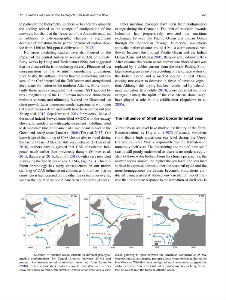
seaway by the late Miocene (ca. 10 Ma, Fig. 23.3). This different chronology has many consequences on our understanding of CAS influence on climate, as it involves that its
constriction has occurred during other major tectonics events,
such as the uplift of the south American cordilleras (Andes).
Other maritime passages have seen their configuration
change during the Cenozoic. The drift of Australia towards
Indochina has progressively restricted the maritime
exchanges between the Pacific Ocean and Indian Ocean
through the Indonesian Passage. Numerical simulations
show that before closure around 4 Ma, a warm ocean current
flowed between the tropical Pacific Ocean and the Indian
Ocean (Cane and Molnar 2001; Brierley and Fedorov 2016).
After closure, this warm ocean current was blocked and was
replaced by a colder current from the north Pacific. Simulated consequences involve a cooling of the surface waters of
the Indian Ocean and a marked drying in East Africa,
causing tree cover to decrease in favor of savanna vegetation. Although this drying has been confirmed by paleoclimate indicators (Bonnefille 2010), more proximal tectonics
changes, namely the uplift of the east African dome might
have played a role in this aridification (Sepulchre et al.
2006).
The Influence of Shelf and Epicontinental Seas
Variations in sea level have marked the history of the Earth.
Reconstructions by Haq et al. (1987) of eustatic variations
show that a high underlying sea level during the Upper
Cretaceous (*95 Ma) is responsible for the formation of
numerous shelf seas. The functioning and role of these shelf
seas is still poorly understood as there is no modern equivalent of these water bodies. From the climate perspective, the
answer seems simple: the higher the sea level, the less land
surface is exposed, the smoother the seasonal cycle and the
more homogeneous the climate becomes. Simulations conducted using a general atmospheric circulation model indicate that the climate response to the formation of shelf seas is
Fig. 22.3 Sketches of putative ocean currents in different paleogeographic configurations for Central America between 25 Ma and
present. Reconstructions of continental areas are from Jaramillo
(2018). Blues arrows show surface currents, and doted-red arrows
show subsurface to mid-depth currents. In these reconstructions, a wide
ocean gateway is open between the American continents at 25 Ma,
whereas only a very narrow passage allows water exchange during the
late Miocene. With this latter configuration, climate models suggest that
surface currents flow westward, while undercurrents can bring fresher
Pacific waters into the tropical Atlantic ocean
22 Climate Evolution on the Geological Timescale and the Role …
261
the cooling related to the change of configuration of the
seaways, but also that the freeze-up of the Antarctic requires,
in addition to paleogeographic changes, a significant
decrease of the atmospheric partial pressure of carbon dioxide from 1160 to 560 ppm (Lefebvre et al. 2012).
Numerous modelling studies have also focused on the
impact of the central American seaway (CAS) on climate.
Early works by Haug and Tiedemann (1998) had suggested
that the closure of the isthmus during the early Pliocene led to a
reorganization of the Atlantic thermohaline circulation.
Specifically, the authors inferred that the shallowing and closure of the CAS intensified the Gulf stream and strengthened
deep water formation in the northern Atlantic. More importantly these authors suggested that warmer SST induced by
this strengthening of the Gulf stream increased atmospheric
moisture content, and ultimately favored the Greenland ice
sheet growth. Later, numerous model experiments with open
CAS with various depth and width have been carried out (see
Zhang et al. 2012; Sepulchre et al. 2014 for reviews). Most of
the model indeed showed intensified AMOC with the seaway
closure, but models run with explicit ice sheet modelling failed
to demonstrate that the closure had a significant impact on the
Greenland icecap onset (Lunt et al. 2008; Tan et al. 2017). Our
knowledge of the timing of CAS closure also evolved during
the last 20 years. Although still very debated (O’Dea et al.
2016), authors have suggested that CAS constriction happened much earlier than previously thought (Montes et al.
2015; Bacon et al. 2015; Jaramillo 2018), with a very restricted
seaway by the late Miocene (ca. 10 Ma, Fig. 23.3). This different chronology has many consequences on our understanding of CAS influence on climate, as it involves that its
constriction has occurred during other major tectonics events,
such as the uplift of the south American cordilleras (Andes).
Other maritime passages have seen their configuration
change during the Cenozoic. The drift of Australia towards
Indochina has progressively restricted the maritime
exchanges between the Pacific Ocean and Indian Ocean
through the Indonesian Passage. Numerical simulations
show that before closure around 4 Ma, a warm ocean current
flowed between the tropical Pacific Ocean and the Indian
Ocean (Cane and Molnar 2001; Brierley and Fedorov 2016).
After closure, this warm ocean current was blocked and was
replaced by a colder current from the north Pacific. Simulated consequences involve a cooling of the surface waters of
the Indian Ocean and a marked drying in East Africa,
causing tree cover to decrease in favor of savanna vegetation. Although this drying has been confirmed by paleoclimate indicators (Bonnefille 2010), more proximal tectonics
changes, namely the uplift of the east African dome might
have played a role in this aridification (Sepulchre et al.
2006).
The Influence of Shelf and Epicontinental Seas
Variations in sea level have marked the history of the Earth.
Reconstructions by Haq et al. (1987) of eustatic variations
show that a high underlying sea level during the Upper
Cretaceous (*95 Ma) is responsible for the formation of
numerous shelf seas. The functioning and role of these shelf
seas is still poorly understood as there is no modern equivalent of these water bodies. From the climate perspective, the
answer seems simple: the higher the sea level, the less land
surface is exposed, the smoother the seasonal cycle and the
more homogeneous the climate becomes. Simulations conducted using a general atmospheric circulation model indicate that the climate response to the formation of shelf seas is
Fig. 22.3 Sketches of putative ocean currents in different paleogeographic configurations for Central America between 25 Ma and
present. Reconstructions of continental areas are from Jaramillo
(2018). Blues arrows show surface currents, and doted-red arrows
show subsurface to mid-depth currents. In these reconstructions, a wide
ocean gateway is open between the American continents at 25 Ma,
whereas only a very narrow passage allows water exchange during the
late Miocene. With this latter configuration, climate models suggest that
surface currents flow westward, while undercurrents can bring fresher
Pacific waters into the tropical Atlantic ocean
22 Climate Evolution on the Geological Timescale and the Role …
261