

more complex than it might appear (Fluteau et al. 2006).
A massive epicontinental sea in North America, the Western
Interior Seaway (WIS), stretched across the North American
continent from the Arctic ocean to the Gulf of Mexico, due
to the sea incursion during the Middle Cretaceous, and to the
dynamic topography caused by the subduction of the Farallon Plate under North America. During the Aptian
(*20 Ma), this arm of the sea had not yet formed. Simulated atmospheric circulation in winter over North America
is driven by a high pressure zone over the northeast of the
continent. In summer, the opposite is the case; a zone of low
pressure develops over the southwest of North America east
of the mountains bordering the Pacific Ocean. The onset of
the WIS completely disrupts the atmospheric circulation in
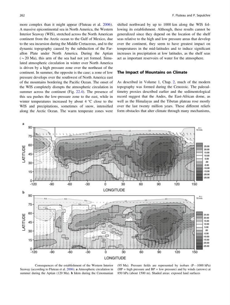
summer across the continent (Fig. 22.4). The presence of
this sea pushes the low-pressure zone to the east, while in
winter temperatures increased by about 4 °C close to the
WIS and precipitations, sometimes of snow, intensified
along the Arctic Ocean. The warm temperate zones were
shifted northward by up to 1000 km along the WIS following its establishment. Although, these results cannot be
generalized since they depend on the location of the shelf
seas relative to the high and low pressure areas that develop
over the continent, they seem to have greatest impact on
temperatures in the mid-latitudes and to induce significant
increases in precipitation at low latitudes, as the shelf seas
act as important reservoirs of water for the atmosphere.
The Impact of Mountains on Climate
As described in Volume 1, Chap. 2, much of the modern
topography was formed during the Cenozoic. The paleoaltimetry proxies described earlier and the sedimentological
record suggest that the Andes, the East-African dome, as
well as the Himalayas and the Tibetan plateau rose mostly
over the last twenty million years. These different reliefs
form obstacles that alter climate through many mechanisms,
Fig. 22.4 Consequences of the establishment of the Western Interior
Seaway (according to Fluteau et al. 2006). a Atmospheric circulation in
summer during the Aptian (120 Ma). b Idem during the Cenomanian
(95 Ma). Pressure fields are represented by isobars (P—1000 hPa)
(HP = high pressure and BP = low pressure) and by winds (arrows) at
850 hPa (about 1500 m). Shaded areas: exposed land surfaces
262
F. Fluteau and P. Sepulchre
A massive epicontinental sea in North America, the Western
Interior Seaway (WIS), stretched across the North American
continent from the Arctic ocean to the Gulf of Mexico, due
to the sea incursion during the Middle Cretaceous, and to the
dynamic topography caused by the subduction of the Farallon Plate under North America. During the Aptian
(*20 Ma), this arm of the sea had not yet formed. Simulated atmospheric circulation in winter over North America
is driven by a high pressure zone over the northeast of the
continent. In summer, the opposite is the case; a zone of low
pressure develops over the southwest of North America east
of the mountains bordering the Pacific Ocean. The onset of
the WIS completely disrupts the atmospheric circulation in
summer across the continent (Fig. 22.4). The presence of
this sea pushes the low-pressure zone to the east, while in
winter temperatures increased by about 4 °C close to the
WIS and precipitations, sometimes of snow, intensified
along the Arctic Ocean. The warm temperate zones were
shifted northward by up to 1000 km along the WIS following its establishment. Although, these results cannot be
generalized since they depend on the location of the shelf
seas relative to the high and low pressure areas that develop
over the continent, they seem to have greatest impact on
temperatures in the mid-latitudes and to induce significant
increases in precipitation at low latitudes, as the shelf seas
act as important reservoirs of water for the atmosphere.
The Impact of Mountains on Climate
As described in Volume 1, Chap. 2, much of the modern
topography was formed during the Cenozoic. The paleoaltimetry proxies described earlier and the sedimentological
record suggest that the Andes, the East-African dome, as
well as the Himalayas and the Tibetan plateau rose mostly
over the last twenty million years. These different reliefs
form obstacles that alter climate through many mechanisms,
Fig. 22.4 Consequences of the establishment of the Western Interior
Seaway (according to Fluteau et al. 2006). a Atmospheric circulation in
summer during the Aptian (120 Ma). b Idem during the Cenomanian
(95 Ma). Pressure fields are represented by isobars (P—1000 hPa)
(HP = high pressure and BP = low pressure) and by winds (arrows) at
850 hPa (about 1500 m). Shaded areas: exposed land surfaces
262
F. Fluteau and P. Sepulchre