

the main cause of the 2002 wildfires that damaged about half of the peatland area and
two-thirds of Melaleuca forest. In particular, mixed forests disappeared completely
in UMT National Park after the 2002 fire (Fig. 29.12a). Due to smoldering combustion below the ground, peat layers underneath were destroyed in a large area,
creating significant low-lying areas, which formed swamps/marshes covered by
aquatic plants and grass when the park was flooded in the subsequent rainy seasons
(Birdlife 2004; Quoi 2010b, 2014b; Triet et al. 2018).
In similar situations, two fires destroyed more than 3000 ha of Melaleuca forest in
U Minh Ha region, including more than 1000 ha of forest inside UMH National Park
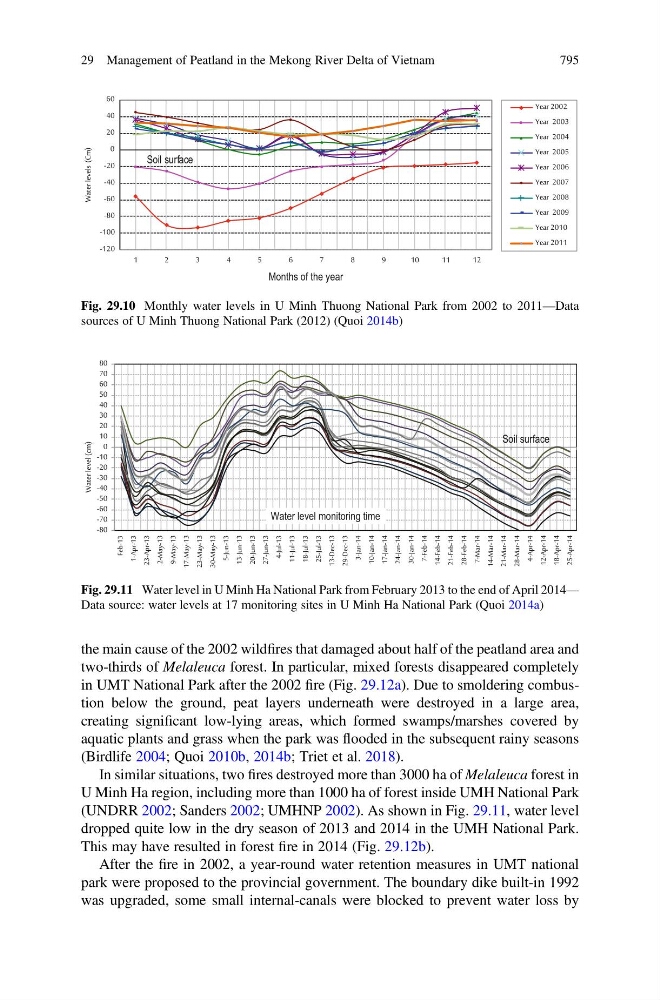
(UNDRR 2002; Sanders 2002; UMHNP 2002). As shown in Fig. 29.11, water level
dropped quite low in the dry season of 2013 and 2014 in the UMH National Park.
This may have resulted in forest fire in 2014 (Fig. 29.12b).
After the fire in 2002, a year-round water retention measures in UMT national
park were proposed to the provincial government. The boundary dike built-in 1992
was upgraded, some small internal-canals were blocked to prevent water loss by
-120
-100
-80
-60
-40
-20
0
20
40
60
1
2
3
4
5
6
7
8
9
1 0
1 1
1 2
Water levels (Cm)
Year 2002
Year 2003
Year 2004
Year 2005
Year 2006
Year 2007
Year 2008
Year 2009
Year 2010
Year 2011
Soil surface
Months of the year
Fig. 29.10 Monthly water levels in U Minh Thuong National Park from 2002 to 2011—Data
sources of U Minh Thuong National Park (2012) (Quoi 2014b)
-80
-70
-60
-50
-40
-30
-20
-10
0
10
20
30
40
50
60
70
80
Feb-13
1-Apr-13
23-Apr-13
2-May-13
9-May-13
17-May-13
23-May-13
30-May-13
5-Jun-13
13-Jun-13
20-Jun-13
27-Jun-13
4-Jul-13
11-Jul-13
18-Jul-13
25-Jul-13
13-Dec-13
29-Dec-13
3-Jan-14
10-Jan-14
17-Jan-14
24-Jan-14
30-Jan-14
7-Feb-14
14-Feb-14
21-Feb-14
28-Feb-14
7-Mar-14
14-Mar-14
21-Mar-14
28-Mar-14
4-Apr-14
12-Apr-14
18-Apr-14
25-Apr-14
Water level (cm)
Soil surface
Water level monitoring time
Fig. 29.11 Water level in U Minh Ha National Park from February 2013 to the end of April 2014—
Data source: water levels at 17 monitoring sites in U Minh Ha National Park (Quoi 2014a)
29 Management of Peatland in the Mekong River Delta of Vietnam
795