

represented the area without canal influence. We assumed that the road structure
components (with compacted peat materials belowground and thus limit macro
porosity) can reduce the water flow into the canal (Kurnianto et al. 2019). The
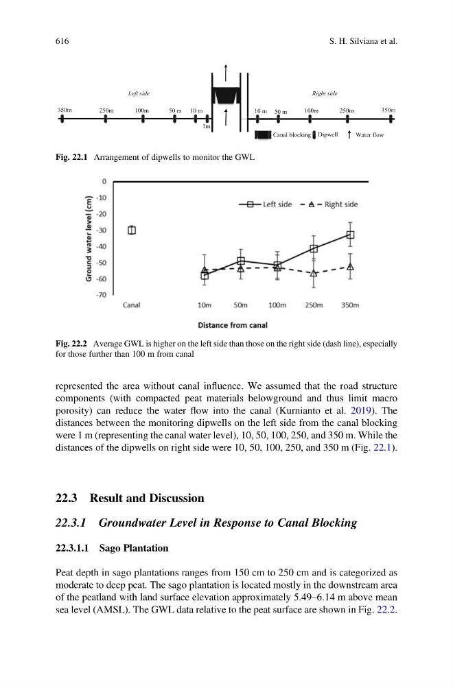
distances between the monitoring dipwells on the left side from the canal blocking
were 1 m (representing the canal water level), 10, 50, 100, 250, and 350 m. While the
distances of the dipwells on right side were 10, 50, 100, 250, and 350 m (Fig. 22.1).
22.3 Result and Discussion
22.3.1 Groundwater Level in Response to Canal Blocking
22.3.1.1 Sago Plantation
Peat depth in sago plantations ranges from 150 cm to 250 cm and is categorized as
moderate to deep peat. The sago plantation is located mostly in the downstream area
of the peatland with land surface elevation approximately 5.49–6.14 m above mean
sea level (AMSL). The GWL data relative to the peat surface are shown in Fig. 22.2.
10 m 50 m
100m
250m
350m
1m
10 m
50 m
100m
250m
350m
r
o
a
d 10 m
r
o
a
d
Canal blocking Dipwell
Water flow
Left side
Right side
Fig. 22.1 Arrangement of dipwells to monitor the GWL
Fig. 22.2 Average GWL is higher on the left side than those on the right side (dash line), especially
for those further than 100 m from canal
616
S. H. Silviana et al.
components (with compacted peat materials belowground and thus limit macro
porosity) can reduce the water flow into the canal (Kurnianto et al. 2019). The
distances between the monitoring dipwells on the left side from the canal blocking
were 1 m (representing the canal water level), 10, 50, 100, 250, and 350 m. While the
distances of the dipwells on right side were 10, 50, 100, 250, and 350 m (Fig. 22.1).
22.3 Result and Discussion
22.3.1 Groundwater Level in Response to Canal Blocking
22.3.1.1 Sago Plantation
Peat depth in sago plantations ranges from 150 cm to 250 cm and is categorized as
moderate to deep peat. The sago plantation is located mostly in the downstream area
of the peatland with land surface elevation approximately 5.49–6.14 m above mean
sea level (AMSL). The GWL data relative to the peat surface are shown in Fig. 22.2.
10 m 50 m
100m
250m
350m
1m
10 m
50 m
100m
250m
350m
r
o
a
d 10 m
r
o
a
d
Canal blocking Dipwell
Water flow
Left side
Right side
Fig. 22.1 Arrangement of dipwells to monitor the GWL
Fig. 22.2 Average GWL is higher on the left side than those on the right side (dash line), especially
for those further than 100 m from canal
616
S. H. Silviana et al.