

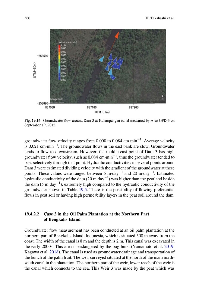
groundwater flow velocity ranges from 0.008 to 0.084 cmÁmin
À1 . Average velocity
is 0.021 cmÁmin
À1 . The groundwater flows in the east bank are slow. Groundwater
tends to flow to downstream. However, the middle east point of Dam 3 has high
groundwater flow velocity, such as 0.084 cmÁmin
À1 , thus the groundwater tended to
pass selectively through that point. Hydraulic conductivities in several points around
Dam 3 were estimated dividing velocity with the gradient of the groundwater at these
points. These values were ranged between 5 mÁday
À1 and 20 mÁday
À1 . Estimated
hydraulic conductivity of the dam (20 mÁday
À1 ) was higher than the peatland beside
the dam (5 mÁday
À1 ), extremely high compared to the hydraulic conductivity of the
groundwater shown in Table 19.5. There is the possibility of flowing preferential
flows in peat soil or having high permeability layers in the peat soil around the dam.
19.4.2.2 Case 2 in the Oil Palm Plantation at the Northern Part
of Bengkalis Island
Groundwater flow measurement has been conducted at an oil palm plantation at the
northern part of Bengkalis Island, Indonesia, which is situated 500 m away from the
coast. The width of the canal is 8 m and the depth is 2 m. This canal was excavated in
the early 2000s. This area is endangered by the bog burst (Yamamoto et al. 2019;
Kagawa et al. 2018). The canal is used as groundwater drainage and transportation of
the bunch of the palm fruit. The weir surveyed situated at the north of the main northsouth canal in the plantation. The northern part of the weir, lower reach of the weir is
the canal which connects to the sea. This Weir 3 was made by the peat which was
Fig. 19.16 Groundwater flow around Dam 3 at Kalampangan canal measured by Alec GFD-3 on
September 19, 2012
560
H. Takahashi et al.
À1 . Average velocity
is 0.021 cmÁmin
À1 . The groundwater flows in the east bank are slow. Groundwater
tends to flow to downstream. However, the middle east point of Dam 3 has high
groundwater flow velocity, such as 0.084 cmÁmin
À1 , thus the groundwater tended to
pass selectively through that point. Hydraulic conductivities in several points around
Dam 3 were estimated dividing velocity with the gradient of the groundwater at these
points. These values were ranged between 5 mÁday
À1 and 20 mÁday
À1 . Estimated
hydraulic conductivity of the dam (20 mÁday
À1 ) was higher than the peatland beside
the dam (5 mÁday
À1 ), extremely high compared to the hydraulic conductivity of the
groundwater shown in Table 19.5. There is the possibility of flowing preferential
flows in peat soil or having high permeability layers in the peat soil around the dam.
19.4.2.2 Case 2 in the Oil Palm Plantation at the Northern Part
of Bengkalis Island
Groundwater flow measurement has been conducted at an oil palm plantation at the
northern part of Bengkalis Island, Indonesia, which is situated 500 m away from the
coast. The width of the canal is 8 m and the depth is 2 m. This canal was excavated in
the early 2000s. This area is endangered by the bog burst (Yamamoto et al. 2019;
Kagawa et al. 2018). The canal is used as groundwater drainage and transportation of
the bunch of the palm fruit. The weir surveyed situated at the north of the main northsouth canal in the plantation. The northern part of the weir, lower reach of the weir is
the canal which connects to the sea. This Weir 3 was made by the peat which was
Fig. 19.16 Groundwater flow around Dam 3 at Kalampangan canal measured by Alec GFD-3 on
September 19, 2012
560
H. Takahashi et al.