

19.4.2.1 Case 1 in Kalampangan Canal in Central Kalimantan
Groundwater flow measurement has been conducted at Kalampangan Canal which is
situated between the Kahayan River and Sebangau River in the suburbs (DB area) of
Palangkaraya, Central Kalimantan Province, Indonesia. The canal, whose length is
10.8 km, connects the Sebangau River and Kahayan River. In 1995, this drainage
channel was excavated, and small drainage channels were added beside the canal
which was developed by the local peoples in the 2010s. The area is located in the
block C area of the ex-Mega Rice Project and covered with a peat layer of 4 m to
2 m. The weir “Dam 3” is made of peat, it is situated 2.5 km away from the Kahayan
River. We conducted the measurement of the groundwater level and groundwater
flow for 14 points around Dam 3. The measurements were conducted on September
19, 2012. At first, we made a borehole by a peat sampler until 2 m and waited around
6 h for stabilization. The vertical distance from the ground surface to the groundwater surface was measured, and the groundwater surface elevation was measured
using Static GPS surveying for each point. Furthermore, the groundwater flow
velocity was measured using GFD-3 at the same point.
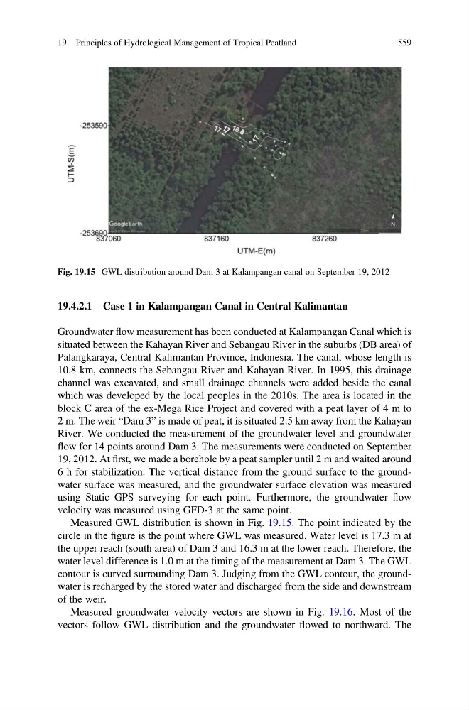
Measured GWL distribution is shown in Fig. 19.15. The point indicated by the
circle in the figure is the point where GWL was measured. Water level is 17.3 m at
the upper reach (south area) of Dam 3 and 16.3 m at the lower reach. Therefore, the
water level difference is 1.0 m at the timing of the measurement at Dam 3. The GWL
contour is curved surrounding Dam 3. Judging from the GWL contour, the groundwater is recharged by the stored water and discharged from the side and downstream
of the weir.
Measured groundwater velocity vectors are shown in Fig. 19.16. Most of the
vectors follow GWL distribution and the groundwater flowed to northward. The
Fig. 19.15 GWL distribution around Dam 3 at Kalampangan canal on September 19, 2012
19 Principles of Hydrological Management of Tropical Peatland
559
Groundwater flow measurement has been conducted at Kalampangan Canal which is
situated between the Kahayan River and Sebangau River in the suburbs (DB area) of
Palangkaraya, Central Kalimantan Province, Indonesia. The canal, whose length is
10.8 km, connects the Sebangau River and Kahayan River. In 1995, this drainage
channel was excavated, and small drainage channels were added beside the canal
which was developed by the local peoples in the 2010s. The area is located in the
block C area of the ex-Mega Rice Project and covered with a peat layer of 4 m to
2 m. The weir “Dam 3” is made of peat, it is situated 2.5 km away from the Kahayan
River. We conducted the measurement of the groundwater level and groundwater
flow for 14 points around Dam 3. The measurements were conducted on September
19, 2012. At first, we made a borehole by a peat sampler until 2 m and waited around
6 h for stabilization. The vertical distance from the ground surface to the groundwater surface was measured, and the groundwater surface elevation was measured
using Static GPS surveying for each point. Furthermore, the groundwater flow
velocity was measured using GFD-3 at the same point.
Measured GWL distribution is shown in Fig. 19.15. The point indicated by the
circle in the figure is the point where GWL was measured. Water level is 17.3 m at
the upper reach (south area) of Dam 3 and 16.3 m at the lower reach. Therefore, the
water level difference is 1.0 m at the timing of the measurement at Dam 3. The GWL
contour is curved surrounding Dam 3. Judging from the GWL contour, the groundwater is recharged by the stored water and discharged from the side and downstream
of the weir.
Measured groundwater velocity vectors are shown in Fig. 19.16. Most of the
vectors follow GWL distribution and the groundwater flowed to northward. The
Fig. 19.15 GWL distribution around Dam 3 at Kalampangan canal on September 19, 2012
19 Principles of Hydrological Management of Tropical Peatland
559