

15.4.2 The Need for Integrated Framework/System
for Monitoring Tropical Peatlands
Measurement, reporting, and verification (MRV) system is important to support
sustainable and climate-responsible management of tropical peatlands. MRV for
GHGs emission is needed to monitor the impacts of land management activities and
assess the effectiveness of the mitigation outcomes. In addition, there is a need to
monitor the environmental and social effects of mitigation activities to ensure that
safeguards are implemented and co-benefits can be maximized (UNFCCC 2010;
Visseren-Hamakers et al. 2012). This will require collections of data, not only
carbon, but also non-carbon, such as biodiversity, livelihood benefits, drivers of
deforestation, forest degradation, peat damage, and fires that could potentially be
integrated into a MRV system. The importance of this integration can be seen from
the consideration of several indicators, including: (i) data and information used,
where some of the same data or information can be used together or support each
other, (ii) data and information collection, where some data can be collected
together, and (iii) synergy of activities, where some activities can be synergized.
Developing and selecting an integration framework for MRV requires consideration of practical and scientific issues including: (i) national and international
reporting requirements, (ii) data availability, (iii) technical means and capacity,
(iv) standards by which the system and its outputs will be assessed, (v) availability
of integration frameworks and the expertise to implement these within the country,
and (vi) cost-effectiveness. IPCC provides guidance for producing unbiased estimations that are reported in a transparent way and are accurate, complete, comparable,
and consistent over time (collectively, these are referred to as the TACCC principles). For the land sector, there are two main methods for integration that can be
applied combining both remote sensing and ground-based observations:
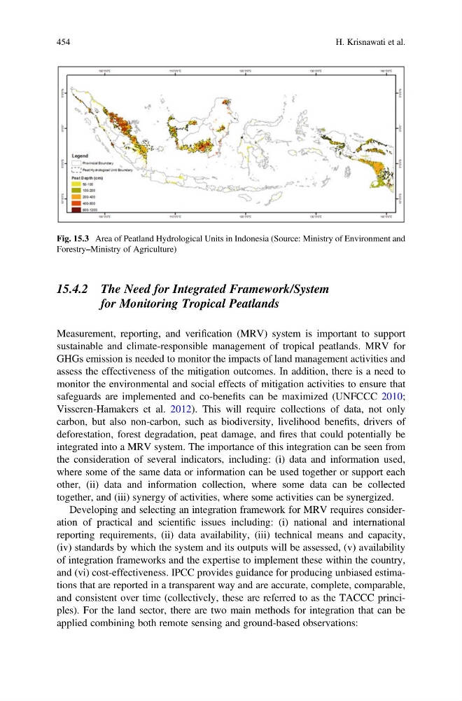
Fig. 15.3 Area of Peatland Hydrological Units in Indonesia (Source: Ministry of Environment and
Forestry–Ministry of Agriculture)
454
H. Krisnawati et al.
for Monitoring Tropical Peatlands
Measurement, reporting, and verification (MRV) system is important to support
sustainable and climate-responsible management of tropical peatlands. MRV for
GHGs emission is needed to monitor the impacts of land management activities and
assess the effectiveness of the mitigation outcomes. In addition, there is a need to
monitor the environmental and social effects of mitigation activities to ensure that
safeguards are implemented and co-benefits can be maximized (UNFCCC 2010;
Visseren-Hamakers et al. 2012). This will require collections of data, not only
carbon, but also non-carbon, such as biodiversity, livelihood benefits, drivers of
deforestation, forest degradation, peat damage, and fires that could potentially be
integrated into a MRV system. The importance of this integration can be seen from
the consideration of several indicators, including: (i) data and information used,
where some of the same data or information can be used together or support each
other, (ii) data and information collection, where some data can be collected
together, and (iii) synergy of activities, where some activities can be synergized.
Developing and selecting an integration framework for MRV requires consideration of practical and scientific issues including: (i) national and international
reporting requirements, (ii) data availability, (iii) technical means and capacity,
(iv) standards by which the system and its outputs will be assessed, (v) availability
of integration frameworks and the expertise to implement these within the country,
and (vi) cost-effectiveness. IPCC provides guidance for producing unbiased estimations that are reported in a transparent way and are accurate, complete, comparable,
and consistent over time (collectively, these are referred to as the TACCC principles). For the land sector, there are two main methods for integration that can be
applied combining both remote sensing and ground-based observations:
Fig. 15.3 Area of Peatland Hydrological Units in Indonesia (Source: Ministry of Environment and
Forestry–Ministry of Agriculture)
454
H. Krisnawati et al.