

0
200
400
600
800
1000
-150
-100
-50
0
50
Jan Feb Mar Apr May Jun Jul Aug Sep Oct Nov Dec
Rainfall (mm)
Water table depth (mm)
Month
Sampit
Palangkaraya
Pangkalan Bun
Buntok
Muara Teweh
Shrub 1
Shrub 2
Forest 1
Forest 2
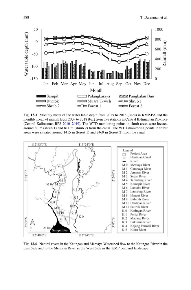
Fig. 13.3 Monthly mean of the water table depth from 2015 to 2018 (lines) in KMP-PA and the
monthly mean of rainfall from 2009 to 2018 (bar) from five stations in Central Kalimantan Province
(Central Kalimantan BPS 2010–2019). The WTD monitoring points in shrub areas were located
around 80 m (shrub 1) and 811 m (shrub 2) from the canal. The WTD monitoring points in forest
areas were situated around 1415 m (forest 1) and 2469 m (forest 2) from the canal
Fig. 13.4 Natural rivers in the Katingan and Mentaya Watershed flow to the Katingan River in the
East Side and to the Mentaya River in the West Side in the KMP peatland landscape
388
T. Darusman et al.
200
400
600
800
1000
-150
-100
-50
0
50
Jan Feb Mar Apr May Jun Jul Aug Sep Oct Nov Dec
Rainfall (mm)
Water table depth (mm)
Month
Sampit
Palangkaraya
Pangkalan Bun
Buntok
Muara Teweh
Shrub 1
Shrub 2
Forest 1
Forest 2
Fig. 13.3 Monthly mean of the water table depth from 2015 to 2018 (lines) in KMP-PA and the
monthly mean of rainfall from 2009 to 2018 (bar) from five stations in Central Kalimantan Province
(Central Kalimantan BPS 2010–2019). The WTD monitoring points in shrub areas were located
around 80 m (shrub 1) and 811 m (shrub 2) from the canal. The WTD monitoring points in forest
areas were situated around 1415 m (forest 1) and 2469 m (forest 2) from the canal
Fig. 13.4 Natural rivers in the Katingan and Mentaya Watershed flow to the Katingan River in the
East Side and to the Mentaya River in the West Side in the KMP peatland landscape
388
T. Darusman et al.