

In fact, the peat swamp forest degradation significantly contributed to the occurrence of several hydrological and meteorological disasters. The serious forest devastation was initiated in 1996 as a result of the construction of massive canals in one
million hectares of peat soil for rice fields through the Mega Rice Project in Central
Kalimantan. Approximately, 4000 km of primary, secondary, and tertiary canals
were developed in the region to dry out the peat soil as can be seen in Fig. 12.3a. Peat
water level sharply decreased, rendering it to be very susceptible to wildfire in the
long dry season and then released a lot of haze (Fig. 12.3b). Efforts to extinguish the
fire should be carried out soon as shown in Fig. 12.3c. During the 1997 ENSO
phenomenon, 1.45 million hectares of peatland burnt out and emitted 156.3 million
tons of C and five million tons of dust particles (BAPPENAS-ADB 1999; Parish
2002). In 2015, there was also a big wildfire that burnt out two million hectares of
forest in Indonesia, incurring a financial loss of around Rp230 trillion (Purnomo
et al. 2016). He added that the peat fire in Central Kalimantan in September 2015 had
devastated 10.015 ha of forest, causing Rp9.3 billion financial loss.
Fire disaster contributes to climate change through CO 2 emissions and other
greenhouse gasses. Haze produced from imperfect burning contains a lot of toxic
compounds and fine particulate matters that cause several diseases (Tacconi 2003;
Saharjo 2011). Evidently, the drainage damages peatland resources. The drainage in
tropical peatland is responsible for nearly 70% of greenhouse gas emissions (~200
Mt. C) from drainage and global fire (Biancalani and Avagyan 2014). The drainage
is usually conducted in relation to planting of dryland plant species, peatland
conversion for transmigration settlements, and development of new districts/cities.
Excessive drainage of peatlands with canal construction also causes significant
soil subsidence and decreased groundwater level (GWL). The subsidence rate is
around 5.2 cm/year (Hooijer et al. 2012). The GWL decrease is closely related to the
2010
2011
2012
2013
2014
2015
2016
2017
2018
2019
Hydrometereology 1941
1633
1811
1674
1967
1732
2342
2372
2572
3814
0
500
1000
1500
2000
2500
3000
3500
4000
4500
No. of incidences
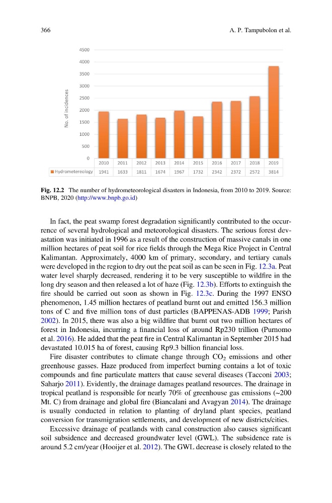
Fig. 12.2 The number of hydrometeorological disasters in Indonesia, from 2010 to 2019. Source:
BNPB, 2020 (http://www.bnpb.go.id)
366
A. P. Tampubolon et al.
million hectares of peat soil for rice fields through the Mega Rice Project in Central
Kalimantan. Approximately, 4000 km of primary, secondary, and tertiary canals
were developed in the region to dry out the peat soil as can be seen in Fig. 12.3a. Peat
water level sharply decreased, rendering it to be very susceptible to wildfire in the
long dry season and then released a lot of haze (Fig. 12.3b). Efforts to extinguish the
fire should be carried out soon as shown in Fig. 12.3c. During the 1997 ENSO
phenomenon, 1.45 million hectares of peatland burnt out and emitted 156.3 million
tons of C and five million tons of dust particles (BAPPENAS-ADB 1999; Parish
2002). In 2015, there was also a big wildfire that burnt out two million hectares of
forest in Indonesia, incurring a financial loss of around Rp230 trillion (Purnomo
et al. 2016). He added that the peat fire in Central Kalimantan in September 2015 had
devastated 10.015 ha of forest, causing Rp9.3 billion financial loss.
Fire disaster contributes to climate change through CO 2 emissions and other
greenhouse gasses. Haze produced from imperfect burning contains a lot of toxic
compounds and fine particulate matters that cause several diseases (Tacconi 2003;
Saharjo 2011). Evidently, the drainage damages peatland resources. The drainage in
tropical peatland is responsible for nearly 70% of greenhouse gas emissions (~200
Mt. C) from drainage and global fire (Biancalani and Avagyan 2014). The drainage
is usually conducted in relation to planting of dryland plant species, peatland
conversion for transmigration settlements, and development of new districts/cities.
Excessive drainage of peatlands with canal construction also causes significant
soil subsidence and decreased groundwater level (GWL). The subsidence rate is
around 5.2 cm/year (Hooijer et al. 2012). The GWL decrease is closely related to the
2010
2011
2012
2013
2014
2015
2016
2017
2018
2019
Hydrometereology 1941
1633
1811
1674
1967
1732
2342
2372
2572
3814
0
500
1000
1500
2000
2500
3000
3500
4000
4500
No. of incidences
Fig. 12.2 The number of hydrometeorological disasters in Indonesia, from 2010 to 2019. Source:
BNPB, 2020 (http://www.bnpb.go.id)
366
A. P. Tampubolon et al.