

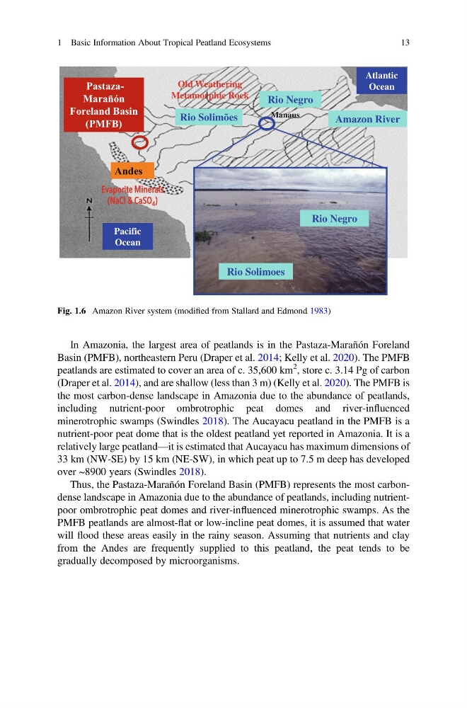
In Amazonia, the largest area of peatlands is in the Pastaza-Marañón Foreland
Basin (PMFB), northeastern Peru (Draper et al. 2014; Kelly et al. 2020). The PMFB
peatlands are estimated to cover an area of c. 35,600 km
2 , store c. 3.14 Pg of carbon
(Draper et al. 2014), and are shallow (less than 3 m) (Kelly et al. 2020). The PMFB is
the most carbon-dense landscape in Amazonia due to the abundance of peatlands,
including nutrient-poor ombrotrophic peat domes and river-influenced
minerotrophic swamps (Swindles 2018). The Aucayacu peatland in the PMFB is a
nutrient-poor peat dome that is the oldest peatland yet reported in Amazonia. It is a
relatively large peatland—it is estimated that Aucayacu has maximum dimensions of
33 km (NW-SE) by 15 km (NE-SW), in which peat up to 7.5 m deep has developed
over ~8900 years (Swindles 2018).
Thus, the Pastaza-Marañón Foreland Basin (PMFB) represents the most carbondense landscape in Amazonia due to the abundance of peatlands, including nutrientpoor ombrotrophic peat domes and river-influenced minerotrophic swamps. As the
PMFB peatlands are almost-flat or low-incline peat domes, it is assumed that water
will flood these areas easily in the rainy season. Assuming that nutrients and clay
from the Andes are frequently supplied to this peatland, the peat tends to be
gradually decomposed by microorganisms.
Old Weathering
Metamorphic Rock
E
Evaporite Minerals
(NaCl & CaSO 4 )
Rio Negro
Manaus
Rio Negro
Rio Solimões
Amazon River
Pacific
Ocean
Atlantic
Ocean
Rio Solimoes
Andes
PastazaMarañón
Foreland Basin
(PMFB)
Fig. 1.6 Amazon River system (modified from Stallard and Edmond 1983)
1 Basic Information About Tropical Peatland Ecosystems
13
Basin (PMFB), northeastern Peru (Draper et al. 2014; Kelly et al. 2020). The PMFB
peatlands are estimated to cover an area of c. 35,600 km
2 , store c. 3.14 Pg of carbon
(Draper et al. 2014), and are shallow (less than 3 m) (Kelly et al. 2020). The PMFB is
the most carbon-dense landscape in Amazonia due to the abundance of peatlands,
including nutrient-poor ombrotrophic peat domes and river-influenced
minerotrophic swamps (Swindles 2018). The Aucayacu peatland in the PMFB is a
nutrient-poor peat dome that is the oldest peatland yet reported in Amazonia. It is a
relatively large peatland—it is estimated that Aucayacu has maximum dimensions of
33 km (NW-SE) by 15 km (NE-SW), in which peat up to 7.5 m deep has developed
over ~8900 years (Swindles 2018).
Thus, the Pastaza-Marañón Foreland Basin (PMFB) represents the most carbondense landscape in Amazonia due to the abundance of peatlands, including nutrientpoor ombrotrophic peat domes and river-influenced minerotrophic swamps. As the
PMFB peatlands are almost-flat or low-incline peat domes, it is assumed that water
will flood these areas easily in the rainy season. Assuming that nutrients and clay
from the Andes are frequently supplied to this peatland, the peat tends to be
gradually decomposed by microorganisms.
Old Weathering
Metamorphic Rock
E
Evaporite Minerals
(NaCl & CaSO 4 )
Rio Negro
Manaus
Rio Negro
Rio Solimões
Amazon River
Pacific
Ocean
Atlantic
Ocean
Rio Solimoes
Andes
PastazaMarañón
Foreland Basin
(PMFB)
Fig. 1.6 Amazon River system (modified from Stallard and Edmond 1983)
1 Basic Information About Tropical Peatland Ecosystems
13