

1.3.3 Peatland Formation in the Congo Basin
In the central Congo Basin, peatlands occupy large interfluvial basins and seem to be
largely rain-fed and ombrotrophic (low-nutrient) systems (Dargie et al. 2017). The
area of peatlands in this region is estimated to be approximately 145,500 km
2 .
Peatlands within the Cuvette Centrale depression are assumed to be flat on the
surface. The average peat depth is 2.4 m. Inundation was observed in the peatlands
while the rivers were still well below their banks. Although supra-annual river
flooding is possible, the peatlands of the Cuvette Centrale region can be considered
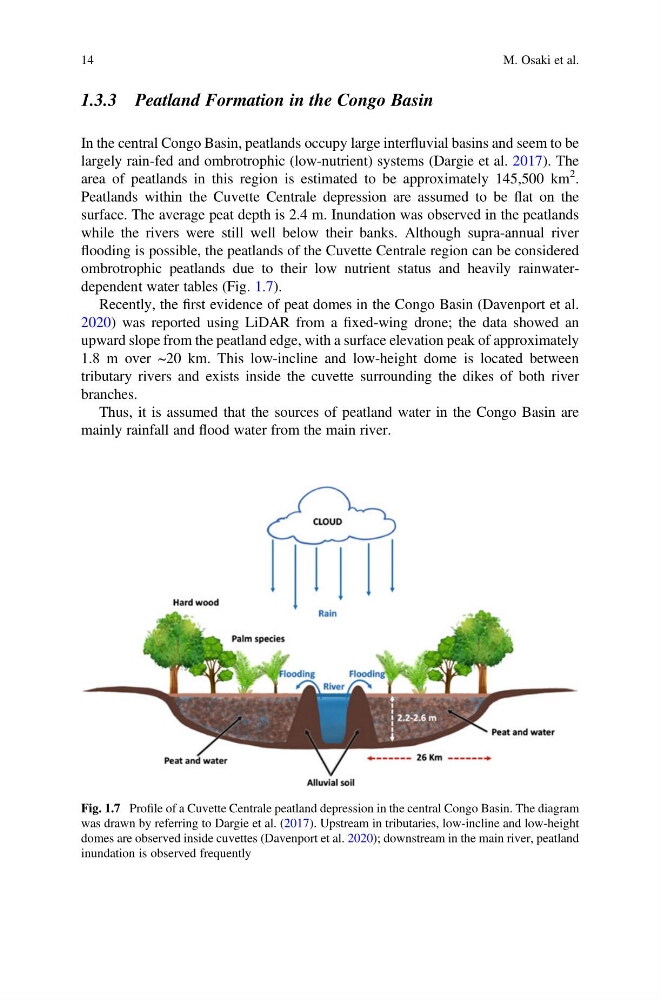
ombrotrophic peatlands due to their low nutrient status and heavily rainwaterdependent water tables (Fig. 1.7).
Recently, the first evidence of peat domes in the Congo Basin (Davenport et al.
2020) was reported using LiDAR from a fixed-wing drone; the data showed an
upward slope from the peatland edge, with a surface elevation peak of approximately
1.8 m over ~20 km. This low-incline and low-height dome is located between
tributary rivers and exists inside the cuvette surrounding the dikes of both river
branches.
Thus, it is assumed that the sources of peatland water in the Congo Basin are
mainly rainfall and flood water from the main river.
Fig. 1.7 Profile of a Cuvette Centrale peatland depression in the central Congo Basin. The diagram
was drawn by referring to Dargie et al. (2017). Upstream in tributaries, low-incline and low-height
domes are observed inside cuvettes (Davenport et al. 2020); downstream in the main river, peatland
inundation is observed frequently
14
M. Osaki et al.
In the central Congo Basin, peatlands occupy large interfluvial basins and seem to be
largely rain-fed and ombrotrophic (low-nutrient) systems (Dargie et al. 2017). The
area of peatlands in this region is estimated to be approximately 145,500 km
2 .
Peatlands within the Cuvette Centrale depression are assumed to be flat on the
surface. The average peat depth is 2.4 m. Inundation was observed in the peatlands
while the rivers were still well below their banks. Although supra-annual river
flooding is possible, the peatlands of the Cuvette Centrale region can be considered
ombrotrophic peatlands due to their low nutrient status and heavily rainwaterdependent water tables (Fig. 1.7).
Recently, the first evidence of peat domes in the Congo Basin (Davenport et al.
2020) was reported using LiDAR from a fixed-wing drone; the data showed an
upward slope from the peatland edge, with a surface elevation peak of approximately
1.8 m over ~20 km. This low-incline and low-height dome is located between
tributary rivers and exists inside the cuvette surrounding the dikes of both river
branches.
Thus, it is assumed that the sources of peatland water in the Congo Basin are
mainly rainfall and flood water from the main river.
Fig. 1.7 Profile of a Cuvette Centrale peatland depression in the central Congo Basin. The diagram
was drawn by referring to Dargie et al. (2017). Upstream in tributaries, low-incline and low-height
domes are observed inside cuvettes (Davenport et al. 2020); downstream in the main river, peatland
inundation is observed frequently
14
M. Osaki et al.