

In the tropical peatland ecosystem, the effectiveness of airborne hyperspectral
applications was demonstrated for estimation of biomass, dissolved organic carbon
(DOC) content, and leaf water potential. The DOC content has a strong correlation
with colored dissolved organic matter (CDOM) absorption, which was derived from
the HyMap band ratios (Hirose et al. 2016). The DOC concentration in peatland river
water depends on the soil carbon content and the degree of peat degradation or
erosion. If the hyperspectral sensor detects a high content of DOC in the peatland
river water, it suggests that the peatland has been severely degraded in the upper
stream. Monitoring of DOC is an important approach to evaluating the dynamic
carbon flux in the peatland ecosystem.
5.6.2 3D Photogrammetry by Unmanned Aerial Vehicle
(UAV)
Several methods can be used to map the topography of peatland surfaces. One of
these methods is a manual survey, which is technically simple and favored by certain
0.5
1.0
1.5
2.0
2.5
9.0 11.0 13.0
HISUI
1
185 bands
VISIBLE
INFRARED
WAVELENGTH
䠄 䠄μm䠅
VISIBLE-NEAR INFRA RED
(VNIR)
SHORT WAVE INFRARED
(SWIR)
THIRMAL INFRARED
(TIR)
GeoEye-1
QuickBird
WorldView-3
Pleiades
IKONOS
RapidEye
Sentinel-2
SPOT-6
Landsat-7
Landsat-8
ASTER
7.0
1
2
3
4
6
8
5 7
9
10 11 12 13 14
1 2
3
4
1 2
3
4
1 2 3 4 5 6 7
1 2
3
4
1 2
3
4
8
1 2
3 4 5
1 2 3
8/8a
1 2
3
4
1 2 3
4
7
5
6
1 2 3 4
6
5
7
10 11
9
10 11 12
13 1415 16
Multispectral Sensor
Hyperspectral Sensor
4 567
11
12
9
10
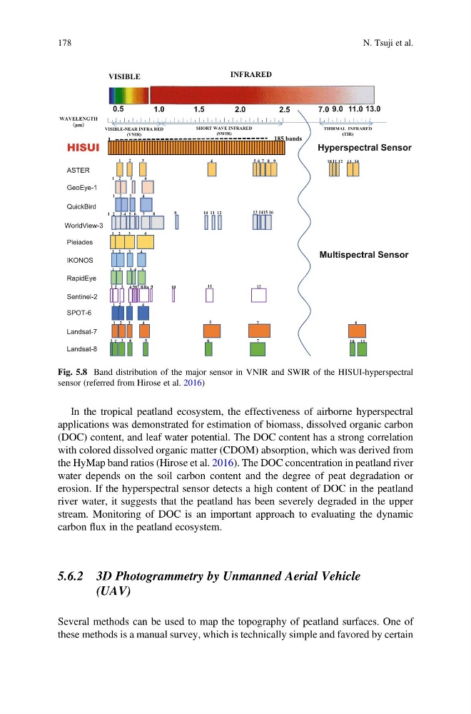
Fig. 5.8 Band distribution of the major sensor in VNIR and SWIR of the HISUI-hyperspectral
sensor (referred from Hirose et al. 2016)
178
N. Tsuji et al.
applications was demonstrated for estimation of biomass, dissolved organic carbon
(DOC) content, and leaf water potential. The DOC content has a strong correlation
with colored dissolved organic matter (CDOM) absorption, which was derived from
the HyMap band ratios (Hirose et al. 2016). The DOC concentration in peatland river
water depends on the soil carbon content and the degree of peat degradation or
erosion. If the hyperspectral sensor detects a high content of DOC in the peatland
river water, it suggests that the peatland has been severely degraded in the upper
stream. Monitoring of DOC is an important approach to evaluating the dynamic
carbon flux in the peatland ecosystem.
5.6.2 3D Photogrammetry by Unmanned Aerial Vehicle
(UAV)
Several methods can be used to map the topography of peatland surfaces. One of
these methods is a manual survey, which is technically simple and favored by certain
0.5
1.0
1.5
2.0
2.5
9.0 11.0 13.0
HISUI
1
185 bands
VISIBLE
INFRARED
WAVELENGTH
䠄 䠄μm䠅
VISIBLE-NEAR INFRA RED
(VNIR)
SHORT WAVE INFRARED
(SWIR)
THIRMAL INFRARED
(TIR)
GeoEye-1
QuickBird
WorldView-3
Pleiades
IKONOS
RapidEye
Sentinel-2
SPOT-6
Landsat-7
Landsat-8
ASTER
7.0
1
2
3
4
6
8
5 7
9
10 11 12 13 14
1 2
3
4
1 2
3
4
1 2 3 4 5 6 7
1 2
3
4
1 2
3
4
8
1 2
3 4 5
1 2 3
8/8a
1 2
3
4
1 2 3
4
7
5
6
1 2 3 4
6
5
7
10 11
9
10 11 12
13 1415 16
Multispectral Sensor
Hyperspectral Sensor
4 567
11
12
9
10
Fig. 5.8 Band distribution of the major sensor in VNIR and SWIR of the HISUI-hyperspectral
sensor (referred from Hirose et al. 2016)
178
N. Tsuji et al.