

5.6 Sensing System
5.6.1 Hypersensor
Multispectral sensors usually have less than 20 bands (e.g., Landsat-8: 11 bands,
WorldView-3: 16 bands) that cover the visible near-infrared (VNIR) and shortwaveinfrared (SWIR) regions (400–2500 nm) with a spectral resolution of more than
30 nm. The hyperspectral sensors that cover more than 200 contiguous bands with
high spectral resolution of less than 15 nm enable measurement of sensitive reflectance energies from objects. Therefore, hyperspectral sensors can be applied for
monitoring in various fields such as vegetation, agriculture, soil, geology, urban,
land use, water resources, and disaster (Transon et al. 2018). Figure 5.8 shows the
band distribution of major spaceborne multispectral sensors and the HISUI
(Hyperspectral Imager SUIte) sensor, which was developed by the Ministry of
Economy, Trade and Industry (METI) of Japan. HISUI has 185 bands (57 bands
in VNIR and 128 bands in SWIR) with 10–12.5 nm spectral resolutions. HISUI was
launched in December 2019, and an initial assessment has been performed.
Airborne hyperspectral sensors have proven their capabilities in various fields
such as discrimination of vegetation types, evaluation of crop growth stage and crop
yield, and disease mapping (Fig. 5.9).
Simulator: SimCycle-Visit
for East Asia
Column averaged dry air mole fraction distribution of carbon dioxide for the
month of September, 2009, obtained from IBUKI observation data
(unvalidated)
By
JAXA
Satellite GOSAT “IBUKI”
Senescing: Atmosphere CO 2
Top-down
• satellite
• airplane
• inverse model
Bottom-up
• field survey
• flux obs.
• process model
Carbon
Budget Map
Carbon Emission by Fire
Carbon Loss through Water
Carbon Emission by Microorganisms
Degradation
Tree Growth/Mortality
Pest subsidence
Carbon-Water Simulation
Subsidence Model
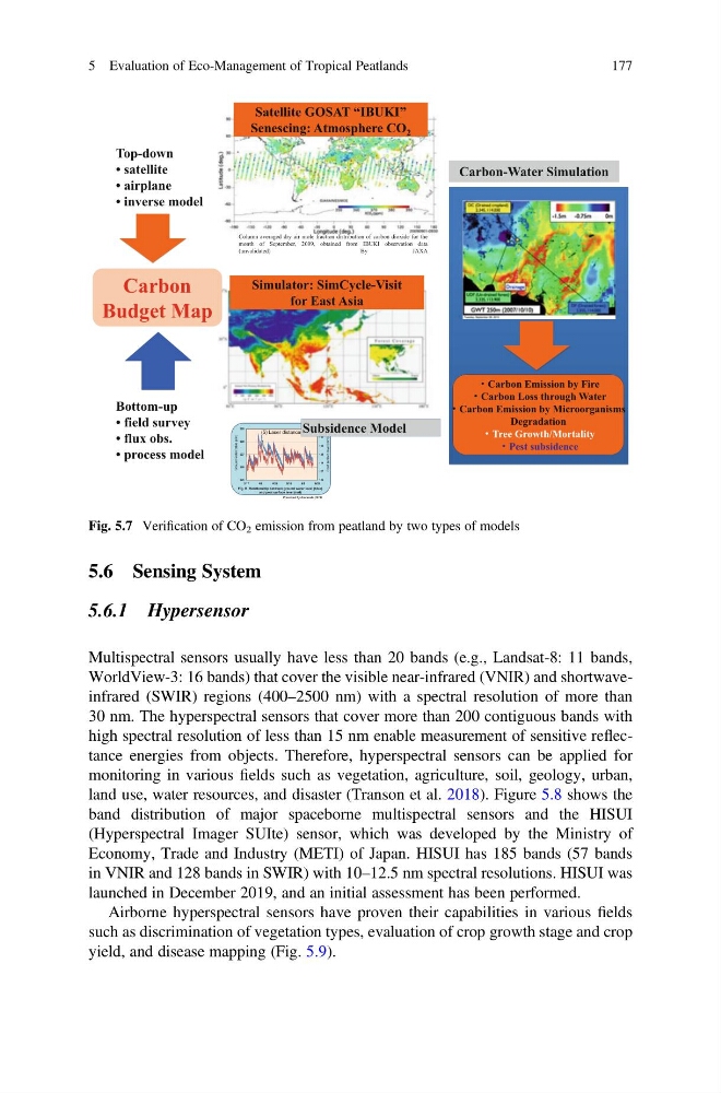
Fig. 5.7 Verification of CO 2 emission from peatland by two types of models
5 Evaluation of Eco-Management of Tropical Peatlands
177
5.6.1 Hypersensor
Multispectral sensors usually have less than 20 bands (e.g., Landsat-8: 11 bands,
WorldView-3: 16 bands) that cover the visible near-infrared (VNIR) and shortwaveinfrared (SWIR) regions (400–2500 nm) with a spectral resolution of more than
30 nm. The hyperspectral sensors that cover more than 200 contiguous bands with
high spectral resolution of less than 15 nm enable measurement of sensitive reflectance energies from objects. Therefore, hyperspectral sensors can be applied for
monitoring in various fields such as vegetation, agriculture, soil, geology, urban,
land use, water resources, and disaster (Transon et al. 2018). Figure 5.8 shows the
band distribution of major spaceborne multispectral sensors and the HISUI
(Hyperspectral Imager SUIte) sensor, which was developed by the Ministry of
Economy, Trade and Industry (METI) of Japan. HISUI has 185 bands (57 bands
in VNIR and 128 bands in SWIR) with 10–12.5 nm spectral resolutions. HISUI was
launched in December 2019, and an initial assessment has been performed.
Airborne hyperspectral sensors have proven their capabilities in various fields
such as discrimination of vegetation types, evaluation of crop growth stage and crop
yield, and disease mapping (Fig. 5.9).
Simulator: SimCycle-Visit
for East Asia
Column averaged dry air mole fraction distribution of carbon dioxide for the
month of September, 2009, obtained from IBUKI observation data
(unvalidated)
By
JAXA
Satellite GOSAT “IBUKI”
Senescing: Atmosphere CO 2
Top-down
• satellite
• airplane
• inverse model
Bottom-up
• field survey
• flux obs.
• process model
Carbon
Budget Map
Carbon Emission by Fire
Carbon Loss through Water
Carbon Emission by Microorganisms
Degradation
Tree Growth/Mortality
Pest subsidence
Carbon-Water Simulation
Subsidence Model
Fig. 5.7 Verification of CO 2 emission from peatland by two types of models
5 Evaluation of Eco-Management of Tropical Peatlands
177