

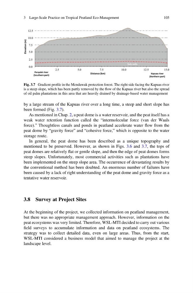
by a large stream of the Kapuas river over a long time, a steep and short slope has
been formed (Fig. 3.7).
As mentioned in Chap. 2, a peat dome is a water reservoir, and the peat itself has a
weak water retention function called the “intermolecular force (van der Waals
force).” Thoughtless canals and ponds in peatland accelerate water flow from the
peat dome by “gravity force” and “cohesive force,” which is opposite to the water
storage route.
In general, the peat dome has been described as a unique topography and
mentioned to be preserved. However, as shown in Figs. 3.6 and 3.7, the tops of
peat domes are relatively flat or gentle slope, and then the edge of peat domes forms
steep slopes. Unfortunately, most commercial activities such as plantations have
been implemented on the steep slope area. The occurrence of devastating results by
the conventional method has been doubted. An enormous number of failures have
been caused by a lack of right understanding of the peat dome and gravity force as a
tentative water reservoir.
3.8 Survey at Project Sites
At the beginning of the project, we collected information on peatland management,
but there was no appropriate management approach. However, information on the
peat ecosystems was very limited. Therefore, WSL-MTI decided to carry out various
field surveys to accumulate information and data on peatland ecosystems. The
strategy was to collect detailed data, even on large areas. Thus, from the start,
WSL-MTI considered a business model that aimed to manage the project at the
landscape level.
Fig. 3.7 Gradient profile in the Mendawak protection forest. The right side facing the Kapuas river
is a steep slope, which has been partly removed by the flow of the Kapuas river but also the spread
of oil palm plantations in this area that are heavily drained by drainage-based water management
3 Large-Scale Practice on Tropical Peatland Eco-Management
105
been formed (Fig. 3.7).
As mentioned in Chap. 2, a peat dome is a water reservoir, and the peat itself has a
weak water retention function called the “intermolecular force (van der Waals
force).” Thoughtless canals and ponds in peatland accelerate water flow from the
peat dome by “gravity force” and “cohesive force,” which is opposite to the water
storage route.
In general, the peat dome has been described as a unique topography and
mentioned to be preserved. However, as shown in Figs. 3.6 and 3.7, the tops of
peat domes are relatively flat or gentle slope, and then the edge of peat domes forms
steep slopes. Unfortunately, most commercial activities such as plantations have
been implemented on the steep slope area. The occurrence of devastating results by
the conventional method has been doubted. An enormous number of failures have
been caused by a lack of right understanding of the peat dome and gravity force as a
tentative water reservoir.
3.8 Survey at Project Sites
At the beginning of the project, we collected information on peatland management,
but there was no appropriate management approach. However, information on the
peat ecosystems was very limited. Therefore, WSL-MTI decided to carry out various
field surveys to accumulate information and data on peatland ecosystems. The
strategy was to collect detailed data, even on large areas. Thus, from the start,
WSL-MTI considered a business model that aimed to manage the project at the
landscape level.
Fig. 3.7 Gradient profile in the Mendawak protection forest. The right side facing the Kapuas river
is a steep slope, which has been partly removed by the flow of the Kapuas river but also the spread
of oil palm plantations in this area that are heavily drained by drainage-based water management
3 Large-Scale Practice on Tropical Peatland Eco-Management
105